You are using an out of date browser. It may not display this or other websites correctly.
You should upgrade or use an alternative browser.
You should upgrade or use an alternative browser.
ARG1
Senior Member
I'm not denying that fact, but at the same time that's not an excuse to strawman every critique of LRT as "angry car drivers". Doing so you ignore all of the real issues with the system and you're ultimately pushing for subpar product given the price.There will always be automobile drivers who will consider light rail to make a ruin of their city centres. Just look how this tram/light rail vehicle made a ruin of this city's sport coliseum. Especially, in a mixed traffic situation in Rome.

From link.
afransen
Senior Member
This is almost right.Preferred surface option:

Just, for section C, eliminate the cycle tracks, make Main one way south only, speed limited to 30 kph (slap in some speed tables/midblock pedestrian crossings for good measure to ensure low speed), shared use with cyclists (with a contraflow cycle lane). Leave the LRT in a dedicated right of way. Northbound car traffic detours.
And section B: get your heads out of your butts and put a MUP on one side for bi-directional cycling + pedestrians. The west side in particular has essentially nothing within 4m of the road that would stop you from putting in a MUP, other than some nice old trees. Sorry, people deserve safe cycling infrastructure more than rich people deserve some old trees. Plant some new ones.
Last edited:
Divas S.
Active Member
why don't they expropriate land to add cycle tracks on segment B? its literally just grass
DKsan
Active Member
They have mixed-traffic LRT operations in Greater Manchester, in sections where the road width is the same as Main Street. The Hurontario LRT will be fine with this, especially as the mixed-section is now shorter than before (previous EA had mixed-operations from Nanwood, not Wellington).
The cycle tracks are a key part of the Downtown Reimagined streetscape project, but as I've repeated throughout this TPAP project, they should just close Main Street off to general traffic and create a transit mall. This was the *preferred* option during the first consultation of the streetscape consultation, an option that the city scrapped for whatever reason.
The cycle tracks are a key part of the Downtown Reimagined streetscape project, but as I've repeated throughout this TPAP project, they should just close Main Street off to general traffic and create a transit mall. This was the *preferred* option during the first consultation of the streetscape consultation, an option that the city scrapped for whatever reason.
ShonTron
Moderator
Main Street between Brampton Mall (Etobicoke Creek) and Wellington Street was recently reconfigured to have one through lane in each direction, one bike lane on each side, and a centre turn lane. It works quite well in that configuration because of the common left-turn movements from Main northbound to Harold, Frederick, and Wellington Streets, southbound to Clarence Street, and the occasional left turn into a residential driveway, the Ward funeral home, and St. Mary's Church/School.
As long as LRT vehicles don't stop between Etobicoke Creek and Wellington, I could even see this work with mixed traffic and bike lanes.
As long as LRT vehicles don't stop between Etobicoke Creek and Wellington, I could even see this work with mixed traffic and bike lanes.
aquateam
Active Member
Latest deck on the Main LRT (aka City of Brampton's LRT Extension Study).
Video of the presentation and discussion during a Council workshop. Virtual public Open House 2: March 25th to April 15th.
Preferred surface option:
View attachment 304306
Preferred tunnel option:
View attachment 304307
The surface loop option has been dropped. The preferred tunnel option does not include an at-grade stop at Elgin, but does include an underground stop at Nanwood.
I'm a bit confused by the preferred options, since the two options that would make the most sense to me weren't even present in the long list of options. These would be either:
- Dedicated centre lanes through downtown (either as a transit mall or without the bike lanes)
- A tunnel for the ~600 metres from south of Wellington to the GO station
Why isn't dedicated centre lanes an option for the downtown portion? The only options with dedicated LRT lanes shift them from the centre to the curb.
For the underground options, they compare different surface cross sections and they compare a George street alignment (not sure why they bother considering it performs worse in absolutely every metric) but they don't compare portal locations.
There might be a valid reason for this (gradient, portal location, avoiding building a new bridge over Etobicoke creek, water table, etc.) but I find it strange that the only underground options all start from south of Nanwood:
- It tunnels for an extra 1.25 km through an area with plenty of RoW and generous setbacks
- The portal and Nanwood stop are both located in a flood plain
Attachments

Monarch Butterfly
Superstar
I'm a bit confused by the preferred options, since the two options that would make the most sense to me weren't even present in the long list of options. These would be either:
- Dedicated centre lanes through downtown (either as a transit mall or without the bike lanes)
- A tunnel for the ~600 metres from south of Wellington to the GO station
Why isn't dedicated centre lanes an option for the downtown portion? The only options with dedicated LRT lanes shift them from the centre to the curb.
View attachment 304676
For the underground options, they compare different surface cross sections and they compare a George street alignment (not sure why they bother considering it performs worse in absolutely every metric) but they don't compare portal locations.
View attachment 304678
There might be a valid reason for this (gradient, portal location, avoiding building a new bridge over Etobicoke creek, water table, etc.) but I find it strange that the only underground options all start from south of Nanwood:
- It tunnels for an extra 1.25 km through an area with plenty of RoW and generous setbacks
- The portal and Nanwood stop are both located in a flood plain
Talking about "flood plain"...
From link.
aquateam
Active Member
Thanks for sharing.
Interesting how all of downtown Brampton is a "flood plain" but not the park space directly bordering Etobicoke creek (Meadowland Park, Centennial Park). From this map it looks like instead of Main street the Hurontario LRT might as well be extended along Etobicoke creek for the same "floodplain" impact.
afransen
Senior Member
Could make it 'low auto', but otherwise a transit mall. This is why I suggest one lane, southbound only. I imagine there is still need for access and loading. Make it slow and clear that it is shared space with bicyclists and pedestrians (for instance, use pavers and have obstacles that create pinch points like trees or planters). I don't think you need cycle tracks in that kind of environment.They have mixed-traffic LRT operations in Greater Manchester, in sections where the road width is the same as Main Street. The Hurontario LRT will be fine with this, especially as the mixed-section is now shorter than before (previous EA had mixed-operations from Nanwood, not Wellington).
The cycle tracks are a key part of the Downtown Reimagined streetscape project, but as I've repeated throughout this TPAP project, they should just close Main Street off to general traffic and create a transit mall. This was the *preferred* option during the first consultation of the streetscape consultation, an option that the city scrapped for whatever reason.
H4F33Z
Active Member
You have a picture of the Main Street with the bike lanes, I can't find it.Main Street between Brampton Mall (Etobicoke Creek) and Wellington Street was recently reconfigured to have one through lane in each direction, one bike lane on each side, and a centre turn lane. It works quite well in that configuration because of the common left-turn movements from Main northbound to Harold, Frederick, and Wellington Streets, southbound to Clarence Street, and the occasional left turn into a residential driveway, the Ward funeral home, and St. Mary's Church/School.
As long as LRT vehicles don't stop between Etobicoke Creek and Wellington, I could even see this work with mixed traffic and bike lanes.
DKsan
Active Member
Why isn't dedicated centre lanes an option for the downtown portion? The only options with dedicated LRT lanes shift them from the centre to the curb.
There's a (split) stop at Wellington/Queen Street in the Downtown portion. There's no room in the road right-of-way to accommodate four lanes + a centre/side platform. Putting the LRT on the sides allows you to use the sidewalk for that purpose without turning into a TTC streetcar stop (which does stop traffic).
Thanks for sharing.
Interesting how all of downtown Brampton is a "flood plain" but not the park space directly bordering Etobicoke creek (Meadowland Park, Centennial Park). From this map it looks like instead of Main street the Hurontario LRT might as well be extended along Etobicoke creek for the same "floodplain" impact.
When the previous Brampton council debated the Main Street portion, a certain anti-Main group proposed putting it in an elevated guideway along the creek. The TRCA shut that option down pretty hard.
There are laneways that businesses use behind the northwest, northeast and southeast blocks of the Main/Queen intersection. There's also laneway access off Queen for the southwest block though it might need to be widened for the bank (there's alternative entrance to that laneway off Main next to City Hall). Harmsworth might complain, as they did last time, but they literally have a dedicated loading slot on John Street. I don't think they need the car lane down Main at all.Could make it 'low auto', but otherwise a transit mall. This is why I suggest one lane, southbound only. I imagine there is still need for access and loading. Make it slow and clear that it is shared space with bicyclists and pedestrians (for instance, use pavers and have obstacles that create pinch points like trees or planters). I don't think you need cycle tracks in that kind of environment.
afransen
Senior Member
In that case, you need an alternate route for southbound traffic... maybe the detour I suggested previously. I would not be a opposed to a car-free solution, but I think that might be more politically difficult than necessary.There's a (split) stop at Wellington/Queen Street in the Downtown portion. There's no room in the road right-of-way to accommodate four lanes + a centre/side platform. Putting the LRT on the sides allows you to use the sidewalk for that purpose without turning into a TTC streetcar stop (which does stop traffic).
When the previous Brampton council debated the Main Street portion, a certain anti-Main group proposed putting it in an elevated guideway along the creek. The TRCA shut that option down pretty hard.
There are laneways that businesses use behind the northwest, northeast and southeast blocks of the Main/Queen intersection. There's also laneway access off Queen for the southwest block though it might need to be widened for the bank (there's alternative entrance to that laneway off Main next to City Hall). Harmsworth might complain, as they did last time, but they literally have a dedicated loading slot on John Street. I don't think they need the car lane down Main at all.
Monarch Butterfly
Superstar
Let's hope that the "Riverwalk Project" does its job at protecting downtown Brampton from flooding.
From link.
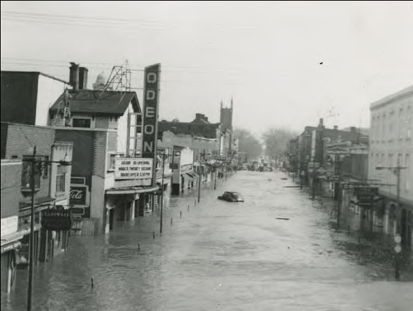
Downtown Brampton used to flood regularly before the storm channel was built. // Courtesy of Brampton
From link.
Downtown Brampton used to flood regularly before the storm channel was built. // Courtesy of Brampton
The Etobicoke Creek through Downtown Brampton reflects 1950s stormwater management: concrete, artificial, and ugly. But by 2025, the river could be completely transformed into a magnificent, yet functional, urban park: the Brampton Riverwalk.
The current course of the Etobicoke Creek isn’t the natural one. In 1952, due to frequent flooding, city council approved a project to divert the flow of the creek around downtown (instead of through it) using a giant concrete channel. This would prove prudent, as downtown avoided the major flooding seen in Mississauga and Toronto during Hurricane Hazel in 1954.
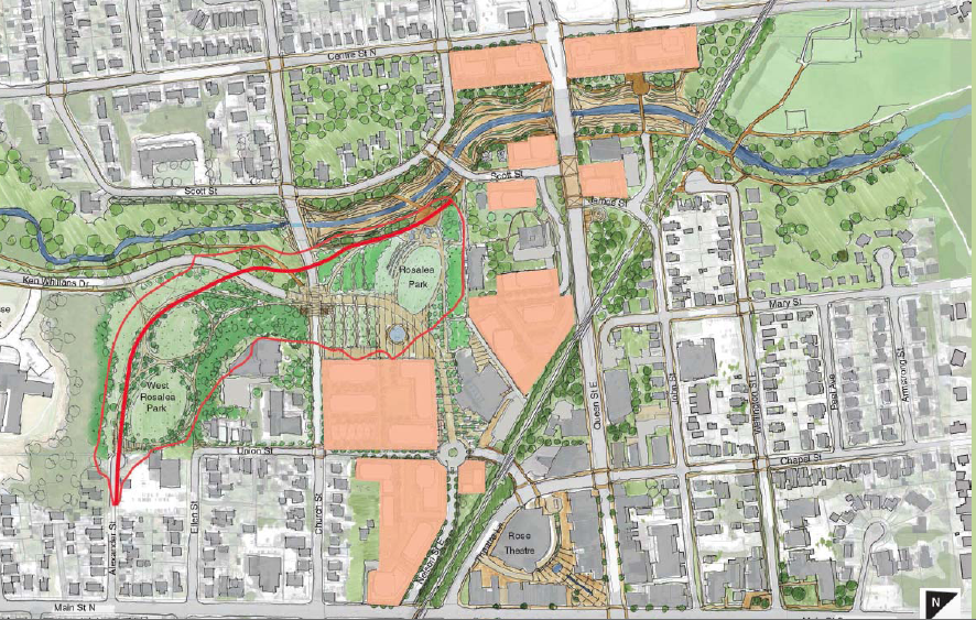
However, the flood mitigation efforts in the concrete channel aren’t enough. As a result, most of downtown Brampton lies in a flood plain, or a Special Policy Area (SPA). It doesn’t prevent new development, but because of potential flood risks, it forces building design to accommodate any flood spillover that could occur with things like storm pumps in parking garage basements, etc, which are expensive.
In a major storm where the channel could fail, it is estimated that most of the SPA would be submerged in 1-2 metres of water. The current channel is only able to handle floods seen in a once-in-a-100-years rains, but with the increasing effects of climate change, it’s possible that these storms could come more often, and bigger rainfalls could overwhelm the current system.
The city and the Toronto Region Conservation Authority (TRCA) have been studying the issue and how to properly handle it since 2011, especially once the provincial Places to Grow Act indicated a greater need for intensification of city centres. They have come up with a project called the Riverwalk, which would completely overhaul the channel.
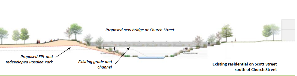
There are several options available to solve the issue, though it seems as if widening, deepening, and naturalizing the channel, rebuilding bridges at Church Street and Clarence Street, and building a flood protection landform (FPL) would be enough to solve flooding risks completely. There’s also an option to build a berm elsewhere.
Naturalization of storm water systems is considered the norm in stormwater management and engineering, and the city embarked on a journey to naturalize most of the valleylands in the 90s. A similar FPL project can be seen with the Corktown Commons project in the West Don Lands in Toronto; that berm is capable of protecting downtown Toronto from floods in the Don Valley.
The total cost of the project was estimated to be at least $100 million in 2014, though this may go up. The federal government has already contributed money toward the studies, and may contribute more through the $2 billion Clean Water and Wastewater Fund.
We hope that IF they go with an underground (AKA subway) LRT, that the entrances, exits, portals, ventilation, electrical shafts, etc. will be (well) above the high water mark.That would also allow for new parcels of land to open up, the city to extend Ken Whillans Drive from Church Street to Union Street, and allow for the space beside the river to open up for new recreational and urban plaza uses, including the missing link of the Etobicoke Creek Recreational Trail through downtown.
The final environmental assessment for the Riverwalk project is expected to start this year, with detailed technical designs starting in 2019. If all goes well, shovels could be in the ground in 2021 with a project completion year of 2025.
Last edited:
Wm Perkins Bull
Active Member
I still have yet to see how these LRT proposals are better than Bus Rapid Transit like that being proposed on Queen, along the whole Highway 10 Rapid Transit corridor. The Main Street portion could be implemented quickly, easily, and cheaply with curb side bus lanes from Nanwood to Vodden, like Metrolinx proposes for the downtown portion of the Queen Street BRT.
Once it is time for Downtown Reimagined, create a Transit Mall on Main from Wellington to Theatre Lane, with deliveries permitted between 2 and 4 am. Carve out a flexible space with rolled curbs by St. Paul's and First Baptist Church where a single vehicle can be permitted to be parked for wedding and funeral services.
Once it is time for Downtown Reimagined, create a Transit Mall on Main from Wellington to Theatre Lane, with deliveries permitted between 2 and 4 am. Carve out a flexible space with rolled curbs by St. Paul's and First Baptist Church where a single vehicle can be permitted to be parked for wedding and funeral services.