News   GLOBAL  |  Apr 02, 2020
 8.5K     0 
News   GLOBAL  |  Apr 01, 2020
 39K     0 
News   GLOBAL  |  Apr 01, 2020
 4.7K     0 


Schaefer said King also supports a move by Environmental Defence calling on the federal government to conduct a full Environmental Assessment on the route.
At least the third municipality to call for this recently, because apparently nobody trusts the Government of Ontario not to tell lies.
 
There are different ways to approach it. One is that used in Houten, a suburb of Utrecht in the Netherlands.


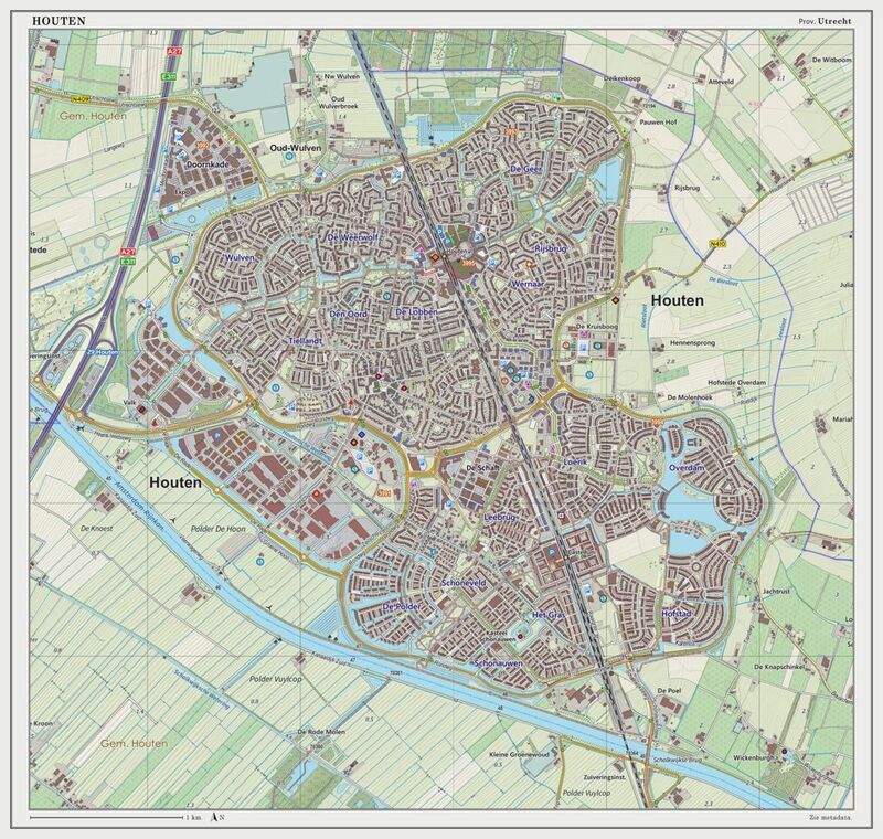
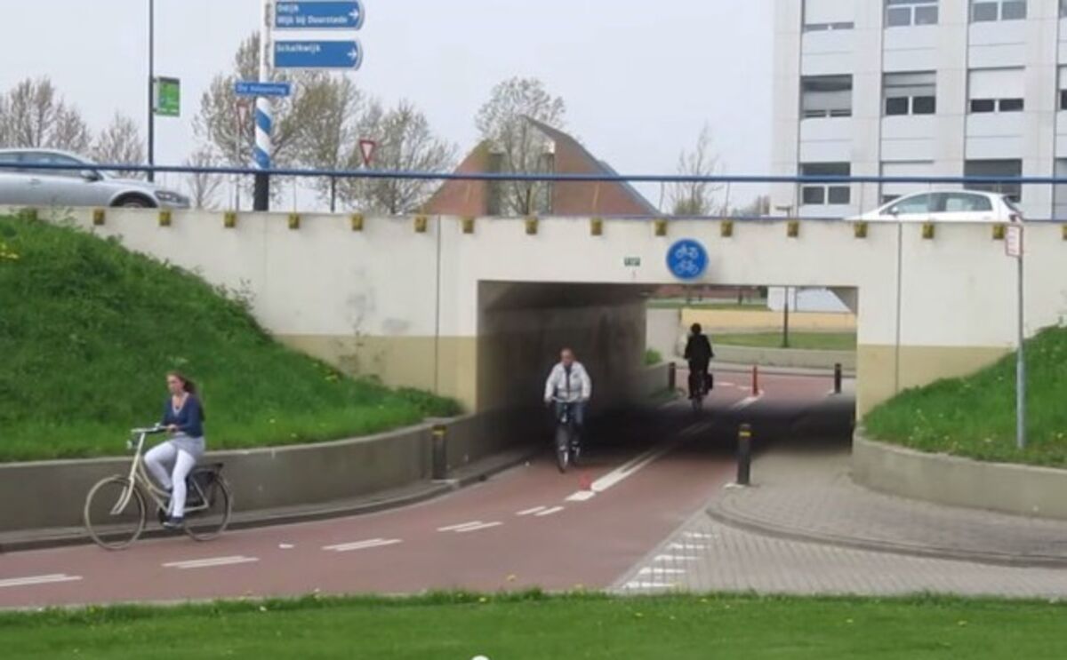
It basically consists of two TOD cells, with an arterial ring road surrounding each cell, a transit station (regional rail) at the centre of each cell, with public space, major commercial/retail and higher density surrounding the station, then lower density toward the outside nearer the ring road. There's no through traffic for cars across the cell, you need to use the ring road. The streets inside are just distributor/access streets. And there are very few uses that are accessed directly off the arterial/ring road. The community is largely SFH, there is lots of car ownership, but there is high transit and active modeshare owing to the design and the pleasant environment for active uses and making cars slightly less convenient. The lower convenience of cars helps to reduce traffic and congestion.

800x-1.jpg


In contrast, when we try to do something similar here in Canada, even in very supposedly progressive places like Innisfil and their 'Orbit' TOD community around their GO station, the plan is to put the station right at a roaring arterial which is a main through-fare for people coming from the existing community headed for the 400. So we'll likely end up with 6 lanes of 60 kph (actually driving 70) traffic going right through the middle of a TOD community. Forget about letting kids ride their bike to school. Then, of course comes the obligatory gigantic parking lot and high speed access road to the station. I would shift the station off the concession and move it mid-block, myself.

Thanks for this, very interesting.

A few thoughts as I am not very familiar with this:

1) I measured the width of the 'node' at about 3 km, so anyone living here is at most about 1.5 km away from the station. Contrast that with MX/GO and think about how far most residents are from most stations making the area quite walkable. Also the next station is about 2 Km think about how many stations would need to be added to the GO network to have 2KM station spacing in the suburbs nevermind the city core. I get your point about putting the transit station at the centre of the node rather than on a major (concession) roadway, but even this is a function of; a) most of Toronto's rail lines are along former industrial lands and so any new station will, by design, be quite far away from a population centre (with some exceptions). It would be interesting to see a new subdivision plan that actually includes new rail trackage for a station that the community is built around. b) the predominant design ideas is that riders will drive (or take transit) to the rail station and thus necessitate both being at a major crossroads and having significant transport options to get in/out of the station area. Few stations in the GTA are built with walk in riders in mind. This all depends on municipal planning as developers do not want spend anymore than they can manage.

2) I think this also proves my main point in my previous point. Despite being an organic road network, there is still a hierarchy of road types, the ring road proto highway, feeding into arterials, then intermediate collectors, which feed into local roads, and finally small streets. As I mentioned above the typical development model here is to go from a concession road right down to local streets with no in between arterials/collectors, and this is a problem. Take for example the, relatively recent, developments around Canada's Wonderland in Maple (only because I most familiar with the area). We have a 4km by 4km area bounded by Jane, Rutherford, Dufferin, and Teston/Major Mackenzie, there are like 3 roads that may be considered intermediate type roads (Mcnaughton/Peter Rupert, Melville, and Barhill) and note how there is practically no East West roadways through the development. This type of development forces people on to the concession road just to move around the area.

That being said sure I see the value of putting a transit station in a centre rather than at a crossroads.
 
1) I measured the width of the 'node' at about 3 km, so anyone living here is at most about 1.5 km away from the station. Contrast that with MX/GO and think about how far most residents are from most stations making the area quite walkable. Also the next station is about 2 Km think about how many stations would need to be added to the GO network to have 2KM station spacing in the suburbs nevermind the city core. I get your point about putting the transit station at the centre of the node rather than on a major (concession) roadway, but even this is a function of; a) most of Toronto's rail lines are along former industrial lands and so any new station will, by design, be quite far away from a population centre (with some exceptions). It would be interesting to see a new subdivision plan that actually includes new rail trackage for a station that the community is built around. b) the predominant design ideas is that riders will drive (or take transit) to the rail station and thus necessitate both being at a major crossroads and having significant transport options to get in/out of the station area. Few stations in the GTA are built with walk in riders in mind. This all depends on municipal planning as developers do not want spend anymore than they can manage.
This is partly why I think our fixation on only using legacy rail ROWs is a bit short sighted. It is darn cheap to build new at-grade rail ROW in greenfield areas on the urban growth boundary. It's even cheaper to park it by reserving the ROW for the rail and station to be added later. We build $250m GO stations but are absolutely terrified of the idea of laying some track in new ROWs--we can't even conceive of the idea. Of course, we have no qualms about building massive new highways ROWs. 2km station spacing is about right for regional rail. Metrolinx will be moving in this direction as they electrify by adding infill stations. Worst-case 1.5km distance to the station makes for a 5-7 minute bike ride at a leisurely speed for the worst case. They have a big bicycle parking facility at the station. And because there is only minimal, low speed interior circulation for cars, it is very cycling friendly. The one change I would make to the model is to integrate GTA-style bus depot near the station, which a bus-only access road from the ring road (perhaps parallel to the rail ROW). Agreed that developers won't want to pay unless required to. It's worth pointing out that there is substantially less roadway required. Might just be a matter of reallocating infrastructure dollars.
 
Last edited:
Article in Today's Toronto Star outlining the species-at-risk that would be impacted by the 413.

Also discussing how the province has exempted itself from having to address that issue in the E.A.

 
an even better idea would be to spend the GTA west highway money to get the Milton line dedicated tracks, all day RER service and operate the Orangeville-Brampton line as a branch of the Milton line, might even have money left over too, considering GTA west is going to cost 6-10 billion.

or we can get that company to get us ULRT... whatever that is...

🖤
 
Last edited:
an even better idea would be to spend the GTA west highway money to get the Milton line dedicated tracks, all day RER service and operate the Orangeville-Brampton line as a branch of the Milton line, might even have money left over to considering GTA west is going to cost 6-10 billion.

or we can get that company to get us ULRT... whatever that is...

🖤
No thanks, I'd rather have my money go into a brand new rail corridor through southern Caledon.

Nice article but its all about Brampton, what about the thousands of people driving from Caledon East to get to work?
 
Last edited:
No thanks, I'd rather have my money go into a brand new rail corridor through southern Caledon.


Nice article but its all about Brampton, what about the thousands of people driving from Caledon East to get to work?
unless you mean an east/west line, extending a couple stops on the line I just made up and the article references the Bolton go line which would both serve southern Caledon.

as for an east/west line, a transitway might be a good idea to connect the new developments to Brampton and the town of Bolton considering how low density everything is and would probably continue to be even when significant development is completed. Also there aren't any major destinations on such a line so having buses be able to branch off would be a good idea.

🖤
 
an even better idea would be to spend the GTA west highway money to get the Milton line dedicated tracks, all day RER service and operate the Orangeville-Brampton line as a branch of the Milton line, might even have money left over to considering GTA west is going to cost 6-10 billion.

or we can get that company to get us ULRT... whatever that is...

🖤
I'm still interested in where that 6-10 billion dollar figure comes from. It seems parroted everywhere yet I can't seem to find an original source other than speculation. 407 East cost 2 billion while being arguably at a similar complexity. Sure it was shorter, it had a similar amount of major interchanges, and at the very least I wouldn't expect prices to triple in 5 years.
 
I'm still interested in where that 6-10 billion dollar figure comes from. It seems parroted everywhere yet I can't seem to find an original source other than speculation. 407 East cost 2 billion while being arguably at a similar complexity. Sure it was shorter, it had a similar amount of major interchanges, and at the very least I wouldn't expect prices to triple in 5 years.
Final costs for the 407 East were recently revealed to be $4.1 billion all in, actually ($2.3 billion for phase 1 and $1.8 billion for phase 2). I believe the $2 billion number is the original, ~2007 cost estimate for it.

$6-10 billion is still far too high though, given the more simplex construction requirements for GTA West than the 407 East (less freeway to freeway interchanges, no realignment of the 401, etc.), and smaller overall size (407 East is about 63km of new highway, GTA West is about 52km with the connections to the 427 and 410)

I suspect final project costs would land in the $3-4 billion range for the highway.

It's the same thing with calling it "413" - as far as I know no government document has ever referred to it as that.
 
Last edited:
Final costs for the 407 East were recently revealed to be $4.1 billion all in, actually ($2.3 billion for phase 1 and $1.8 billion for phase 2). I believe the $2 billion number is the original, ~2007 cost estimate for it.

$6-10 billion is still far too high though, given the more simplex construction requirements for GTA West than the 407 East (less freeway to freeway interchanges, no realignment of the 401, etc.), and smaller overall size (407 East is about 63km of new highway, GTA West is about 48km)

I suspect final project costs would land in the $3-4 billion range for the highway.

It's the same thing with calling it "413" - as far as I know no government document has ever referred to it as that.
I can't remember where the 413 came from, but I made a map of the highway on Google and I called it Highway 413 and I'm constantly getting access requests from people for it lol. My map has had over 700,000 views :p
 
I'm still interested in where that 6-10 billion dollar figure comes from. It seems parroted everywhere yet I can't seem to find an original source other than speculation. 407 East cost 2 billion while being arguably at a similar complexity. Sure it was shorter, it had a similar amount of major interchanges, and at the very least I wouldn't expect prices to triple in 5 years.

Final costs for the 407 East were recently revealed to be $4.1 billion all in, actually ($2.3 billion for phase 1 and $1.8 billion for phase 2). I believe the $2 billion number is the original, ~2007 cost estimate for it.

$6-10 billion is still far too high though, given the more simplex construction requirements for GTA West than the 407 East (less freeway to freeway interchanges, no realignment of the 401, etc.), and smaller overall size (407 East is about 63km of new highway, GTA West is about 52km with the connections to the 427 and 410)

I suspect final project costs would land in the $3-4 billion range for the highway.

It's the same thing with calling it "413" - as far as I know no government document has ever referred to it as that.
The same can be said about this "only saving 10 seconds" like where are the sources for this?
 
^^ did someone cut off y'all access to google or something??
I've seen the claims for the numbers, I haven't seen proper sourcing, which is what I'm asking for. Any dumb news website can throw numbers like 6-10 bill, I'm asking for the evidence.
 

Back
Top