


innsertnamehere
Superstar
That article makes it pretty clear that public opening will be late 2022 or early 2023.
|
|
|
Is there a good reason why there’s so many types? Whether they use the international standard or their own made up one, at least pick a lane and stick to it. Also in that Google Street View, why do they need a light there? it’s a right of way with no intersection and no crossover tracks and no visibility issues.Waterloo's ION only uses the white bar signals at mixed traffic intersections, on the off-street rights of way they still use red and green circles, and on the in-median rights of way they use red, green, and yellow bars. This crossover protection signal would have been bars in Waterloo, and placed as a double head in the center of the median rather than hung off to the right so close to the car traffic:

Does anyone want to guess when traffic around Bayview/Eglinton and Allen Rd/Eglinton will be back to normal? I'm hoping and wishing for sometime in the Spring, but that's nothing more than a wild guess.
Does anyone want to guess when traffic around Bayview/Eglinton and Allen Rd/Eglinton will be back to normal? I'm hoping and wishing for sometime in the Spring, but that's nothing more than a wild guess.
They've started to remove the wooden roadway decking and backfilling the structure at Bayview. There are going to have to be a number of traffic shifts in order to finish all of it, but it looks like the end is finally in sight - at least in terms of traffic headaches.Does anyone want to guess when traffic around Bayview/Eglinton and Allen Rd/Eglinton will be back to normal? I'm hoping and wishing for sometime in the Spring, but that's nothing more than a wild guess.
That plaza on the NE corner is slated for redevelopment. It's been closed and fenced off for a couple of years. I'm sure the construction for that will cause traffic issues. I'm just glad they made the developers wait until the Crosstown is done!Bad news. It will never look like Bayview and Eglinton in the 1950's again...
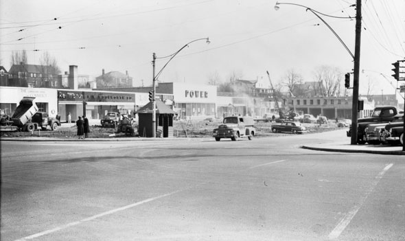
Construction at the northeast corner of Eglinton and Bayview in 1952. The Power supermarket building is still standing--it's the Rexall pharmacy mentioned above in Sunnybrook Plaza. The Reitman's is long gone.
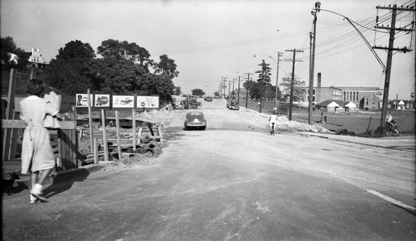
Looking east on Eglinton from just east of Bayview in 1951. That's Howard Talbot Park and Leaside High School on the right. Today, the land on the left is home to strip plaza anchored by a Rexall pharmacy.
See link.
Is there a good reason why there’s so many types? Whether they use the international standard or their own made up one, at least pick a lane and stick to it. Also in that Google Street View, why do they need a light there? it’s a right of way with no intersection and no crossover tracks and no visibility issues.
Well... let's see how long they'll last against the snow plows...
My guess is finished and at least in-testing. Tough to make a call on whether it goes into passenger service this year though.We are officially into 2022, does Eglinton get finished this year
Nah I don't think so. The reason the Confederation line doesn't work as well is that those Alstom trains (they'll also be used on the upcoming Finch west LRT) were not meant to be used on that line. But the order had already been in so they had no choice but to use those trains. Because of this, the trains aren't equipped to deal with the high volume of ppl boarding the trains on the daily. This is why the doors would malfunction with derailments. Eglinton are using the Bombardier trains (which I'm not a fan of) and our line should be more tolerable to those trains.Open in 2023.
2024 it will close again for a few months when they find defects à la Confederation Line.
