dunkalunk
Senior Member
I don't really see the point of a subway underneath King with the rail corridor so closeby. If SmartTrack is happening, the next logical place for a east-west downtown subway is Queen Street.
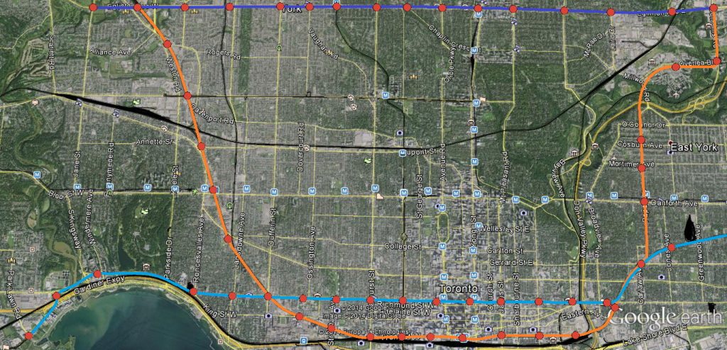
In a perfect world, we would be building something like this:
As I said before, if we're building SmartTrack (cyan) as complimentary to a true DRL (orange); have the second subway line travel across the central core west to the developments along the Humber Bay area. Think of all the nodes/trip generators within easy walking distance of Queen (Chinatown, Queen West, CAMH lands, Parkdale, SoHo, Eaton Centre, City Hall, Regent Park) that'd be so much harder to access if the alignment were King.
Meanwhile a DRL following the rail corridors, the Esplanade and Front St W would allow for easy walking distance access to: Unilever, West Don Lands, the Distillery District, St Lawrence, Union Station, CN Tower/Ripley's/Skydome, CityPlace, Liberty Village. A King alignment only has a more direct connection to the Financial District going for it, so in my opinion dual subway lines through the core are of more benefit than trying to force everyone onto King.
I like the general concept, however, I'm not sure how feasible the station frequency you have illustrated on the rail corridor is, in particular the track bottleneck between the Don River and Pape.
Space in rail corridors need to be reserved to run regional rail services. When multiple GO lines merge, in addition to whatever other VIA or HSR servicis running on the same rail corridor that corridor is going to become very constrained and won't have enough room for infill stations. The 800m Metro-type spacing you've illustrated won't really be all that feasible south of Bloor. Subways need more frequent spacing, thereby making subway alignments under arterial roads where the people are more appropriate. (It's kind of difficult to intensify on top of an active rail corridor.)
To help illustrate this, below is a cutaway from a fantasy map I've been working on.

(Aside: the teal line is this map is re-purposing the UPX ROW for local service. Actual express service between Union and Pearson would continue to operate on regular GO track)
Last edited:


