People in some downtown condos could be jumping onto the Gardiner now, or from the Dufferin Street bridge, and it doesn't happen.

42

Absolutely. I was being facetious with my comment lol. Let's see how the finished product turns out 10+ years from now.
 
Between the Exhibition Station and Ontario Place, is the asphalt desert most would have to safari across...

1648405506910-png.388136
From link.
camel-ride-fail-fell-down.gif
From link.
 
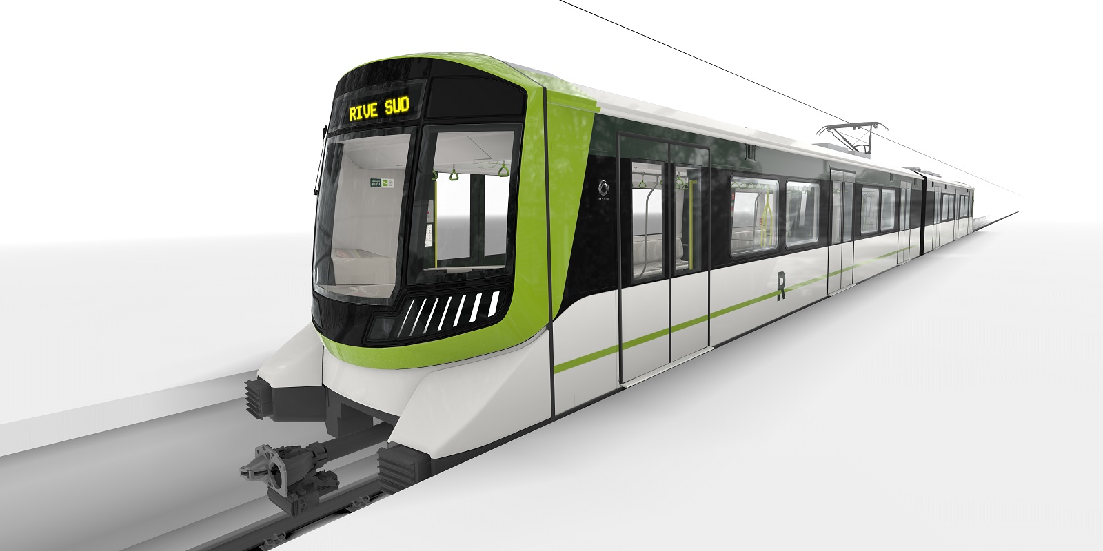
just to add, the LRT like design you see in the 1st image is most definitely placeholder, expect something more alike the to vancouver skytrain cars. high floor automated light-metro trains
The specifications Metrolinx have released have been almost a dead-ringer for Montreal's REM trains, which are essentially off the shelf standard subway trains with overhead catenary. They are larger than Skytrain vehicles, but smaller than TTC subway vehicles:

REM-exterieur1.jpg
 
The specifications Metrolinx have released have been almost a dead-ringer for Montreal's REM trains, which are essentially off the shelf standard subway trains with overhead catenary. They are larger than Skytrain vehicles, but smaller than TTC subway vehicles:

REM-exterieur1.jpg
i mean ya Alstom is one of the bidders.
siemens and hitachi are also bidding.
if youre referring to the PDBC then ya all bidders have trains that qualify
we wont know until October at the earliest who wins though
 
That will likely change once the streetcar tracks are extended to the Dufferin Loop. The city has been waiting for the design of Exhibition station to be finalized before advancing that plan, but from my understanding they have funding for it.
The Dufferin Loop is on the north side of the track and the Exhibition Loop is on the south side, so i'm not sure how they can get these to join without an overpass (which doesn't seem to be a part of the exhibition GO-OL station)? ~850metres separating them right now. Please let me know. It would be great to Loop-da-Loops!
 
The Dufferin Loop is on the north side of the track and the Exhibition Loop is on the south side, so i'm not sure how they can get these to join without an overpass (which doesn't seem to be a part of the exhibition GO-OL station)? ~850metres separating them right now. Please let me know. It would be great to Loop-da-Loops!
You should have seen the other threads, including the https://urbantoronto.ca/forum/threads/will-liberty-village-get-its-much-needed-new-street.18232/post-1791394 thread.

From Exhibition Station at https://engageio.ca/en/engagement-initiatives/exhibition as part of the Ontario Line project.

1645115055428-png.380693

A new street along the southern boundary of Liberty Street is proposed, named “Liberty New Street”. The new street will have a two-lane cross-section and will extend between Dufferin Street and Strachan Avenue, immediately north of the railway corridor, intersecting with Mowat Avenue, Fraser Avenue, Jefferson Avenue, Atlantic Avenue, Hanna Avenue, and Pirandello Street. Sidewalks will be provided along the north side of Liberty New Street, and a multi-use path will be provided along the south side to accommodate pedestrians and cyclists. Since the control type at each intersection was not specified in the EA, the intersection control measures recommended in the Ontario Line Exhibition Station Site Plan Review Transportation Impact Assessment (Ontario Line Technical Advisor, May 2021) were carried forward, with the intersection of Jefferson Avenue and Liberty New Street being all-way stop-controlled, Atlantic Avenue and Liberty New Street being signalized, Dufferin Street and Liberty New Street being signalized, and Strachan Avenue and Liberty New Street being a right-in/right-out configuration.
Ontario Line:

Exhibition Station will be a terminal station for the proposed Ontario Line subway, which will operate at 90-second headways, connecting Liberty Village and Exhibition Place with the neighbourhoods along the Ontario Line alignment to the east. Exhibition Station will also provide convenient access to the Lakeshore West GO rail and TTC streetcar services nearby.
Lakeshore West GO Train:

GO train frequencies are expected to increase over time following electrification of the corridor, resulting in 15-minute peak service, and 30-minute off peak services in both directions. New eastbound and westbound express GO platforms will be added to Exhibition Station, to be located in the middle of the station just north of the eastbound local GO platform at the southern end.
Streetcar Extension:

The TTC has plans to extend the existing streetcar services from the Exhibition Loop to the Dufferin Gates Loop as part of the Waterfront LRT, providing enhanced streetcar connections within the network west of Exhibition Place.

Changes resulting from the extension project will include:
  • New westbound streetcar platform at Manitoba Drive / Nova Scotia Avenue;
  • Possible grade-separated north-south crossings for pedestrians at Manitoba Drive / Nova Scotia Avenue to be used during special event peak hours;
  • New streetcar stop at Centennial Park (Dufferin Gates) for both directions, located north of Centennial Park east of Dufferin Street. The west side of the intersection to be protected for a future westerly extension; and
  • Signalization of Dufferin Street at the Dufferin Loop.
Bus Transit Services:

Bus bays will be located on Liberty New Street
to accommodate redirection of bus routes through Liberty Village. The westbound bus bay will be located between Jefferson Avenue and Atlantic Avenue, and the eastbound bus bay will be located just east of Atlantic Avenue (based on current assumptions and subject to change based on City of Toronto and TTC future plans). The new bus bays will accommodate Route 29A (Dufferin) with a 3.3-minute headway, 63 (Ossington) with a 3.5-minute headway, and 929 (Dufferin Express).

As usual, the City of Toronto takes forever to rebuilt the Dufferin overpass that goes over the Gardiner and railway. It is supposed to be able to support heavier traffic, including the streetcars and heavy trucks. The anti-transit councillors and powers-that-be keep looking at any excuse NOT to finish the bridge.
 
Last edited:
Hi all. I hope, and can only assume that these photos are relevant to this thread. Was at Exhibition today, and there is significant demolition of the buildings immediately north of the tracks underway. Perhaps it’s been going on for some time. Lots of workers onsite.
0BC5A965-9BA7-415C-9C27-4E23D5E660A1.jpeg
A78A58FD-E924-4C54-A167-76AB478FCADE.jpeg
289C1A93-13E0-4293-B3DE-E8F5A253B416.jpeg
 
The specifications Metrolinx have released have been almost a dead-ringer for Montreal's REM trains, which are essentially off the shelf standard subway trains with overhead catenary. They are larger than Skytrain vehicles, but smaller than TTC subway vehicles:

REM-exterieur1.jpg
The Sydney Metro also uses the same trains, but in a 6-car format (Source).
0402_Chatswood,_2019_(01).jpg
 
Looking down from above, this is way nicer than the crappy bush trainshed at Union Station.

Honestly though, this is more like the new atrium by Zeidler attached to some barely there platform roofing. In any case, we shall see whether they will build it as presented or not (I have some doubts).

AoD
 
Looking at the plot plan in the previous page of this rail hub. It shows the subway line rails being elevated. Is that rail section west of the station going to be the part where tain can change lanes to go back up to Eglinton station? And could this line in the future travel west ward maybe through Hyde Park etc being elevated? I WAS JUST WONDERING!
 
Last edited:
Looking at the plot plan in the photo up above of this rail hub. It shows the subway line rails being elevated. Is that rail section west of the station going to be the part where tain can change lanes to go back up to Eglinton station? And could this line in the future travel west ward maybe through Hyde Park etc being elevated? I WAS JUST WONDERING!
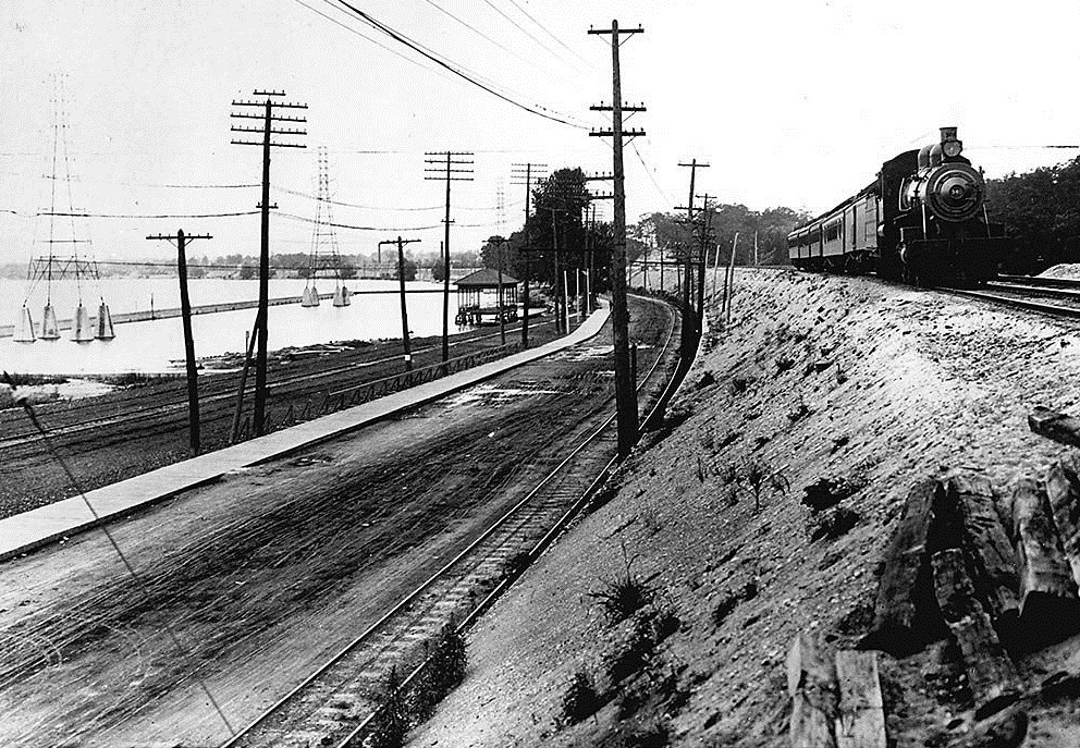
The foot of High Park or Sunnyside is a sandbar. Originally, the sandbar only supported two sets of railway tracks, a single-track radial streetcar line, and a narrow road. They added landfill (dirt, old bricks, etc.) to make room for more railway tracks (total four), the current roads and "beach" (former an amusement park).

sunnside-in-1908.jpg
From link.
 

Back
Top