Where have you been. All I keep reading is theat employers are moving back to downtown Toronto to young urban workers who want to live in downtown Toronto

I have been looking at the data, that's where I have been. Toronto consist of more than downtown. My point still stands. Vaughan (and Mississauga) are both net importers of labour from Toronto. WRT downtown, perhaps you have mistaken the dead cat bounce for a real recovery. If you really consider a city that, since 1989, has 548k more residents but 55k less jobs, a success then there is really no point engaging with you.
 
The Yonge line actually makes a small profit. The tiny Sheppard line costs 10 million a year in subsidies.

Looking to win an argument - do you know where I can see that written/quoted in the mainstream press or an official document?
 
Looking to win an argument - do you know where I can see that written/quoted in the mainstream press or an official document?

Regarding the Yonge line, I remember seeing that point brought up a couple of times in Steve Munro's blog a while ago, but for some reason I can't find it. As for the Sheppard line: http://www.postcity.com/Post-City-Magazines/October-2012/Subway-subsidized-to-tune-of-10-mil-a-year/

Anyways, this was debated a while ago, but I hope this helps.
 
Looking to win an argument - do you know where I can see that written/quoted in the mainstream press or an official document?

I know this isn't what you're looking for, but this TTC document may be useful for you. It was buried by the Ford administration back in 2011, but leaked by the Toronto Star. It's an overview of why the Sheppard Subway has failed to meet 1984 expectations of the line.
 
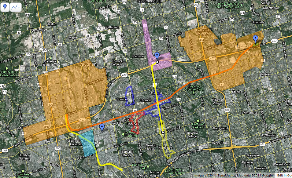
Here is a map of Southern York Region south to North York Centre that I created a few years ago in discussion s on an east west rail link for York Region. On the map I highlighted the large commercial/industrial zones of each Markham and Vaughan, the areas of planned intensification along the Yonge corridor and the large existing residential nodes. Yonge neatly divides the region and effectively connects North York City Centre with the regions to the north where arguably there is a greater concentration of employment lands than anything in Toronto outside of the core.
It's long past time when we can assume that everyone who will get on the extended Yonge line has to get downtown. If we offer options to those living and working in the North, maybe we can effectively connect these significant nodes more effectively.

6685194673_c208585f32_b.jpg
 
So the office node in Vaghuan doesn't really employ many people in comparison to the 404-407 ... which is huge ... even bigger then the map shows !
I say this because Vaghaun is still by far and large industrial.

I honestly think a subway to somewhere in Markham makes sense ! But if it'd be used is a completely different story !

By far and large, all the existing office stock in that area is extremely suburban ... buildings in a see of parking ... and people like it that way ! Or better put are used to it. Putting a subway there won't change much.

I'm also willing to bet a lot of poeple who work in this area live somewhere in the 905 or upper 416, so a subway isn't quite as useful in this sense. I'm not sreally sure what will help.

When the transit way finishes, I think we should access how it does (I have my doubts) if it does really well it means people are willing to make changes if transit is more convenient
 
Those orange areas on the map are huge but density wise still quite low. How many downtown Toronto financial districts could you fit into those areas with room still left over? Quite a few. The low density makes transit hard here.
 
@TJ, I think most people (and maybe even yourself) often forget or simply don't even know that GO operates buses all day both ways.

Just because a train isn't running, doesn't mean you don't have an awesome, fast, and effective way downtown from the usual stations.

Granted, not every station gets that service but pretty much all the ones outside Toronto proper do. Check it out sometime. You can get from Unionville GO to downtown and vice versa in 30 minutes whenever you want until 2am. So I'm sure Langstaff has a similar schedule.
 
Here is a map of Southern York Region south to North York Centre that I created a few years ago in discussion s on an east west rail link for York Region. On the map I highlighted the large commercial/industrial zones of each Markham and Vaughan, the areas of planned intensification along the Yonge corridor and the large existing residential nodes. Yonge neatly divides the region and effectively connects North York City Centre with the regions to the north where arguably there is a greater concentration of employment lands than anything in Toronto outside of the core.
It's long past time when we can assume that everyone who will get on the extended Yonge line has to get downtown. If we offer options to those living and working in the North, maybe we can effectively connect these significant nodes more effectively.

Interesting map. But doesn't the 407 Transitway accomplish virtually the same goal? And with significantly more flexibility and a lower cost for that matter.

A rail-based solution would be nice, but I think being able to seamlessly switch from the 407 Transitway to the VIVA Highway 7 Rapidway and vice versa at either end of it is a nice bonus. What I mean by that is a VIVA bus runs 'local' from Cornell to downtown Markham, and then express (or only stopping at the limited number of stops on the Transitway) to Yonge or the Spadina Subway.

The Transitway can also be one piece of a larger dedicated road BRT network across the GTA.
 
So the office node in Vaghuan doesn't really employ many people in comparison to the 404-407 ... which is huge ... even bigger then the map shows !
I say this because Vaghaun is still by far and large industrial.

I honestly think a subway to somewhere in Markham makes sense ! But if it'd be used is a completely different story !

By far and large, all the existing office stock in that area is extremely suburban ... buildings in a see of parking ... and people like it that way ! Or better put are used to it. Putting a subway there won't change much.

I'm also willing to bet a lot of poeple who work in this area live somewhere in the 905 or upper 416, so a subway isn't quite as useful in this sense. I'm not sreally sure what will help.

When the transit way finishes, I think we should access how it does (I have my doubts) if it does really well it means people are willing to make changes if transit is more convenient

Just because it's like that today doesn't mean we can't take action to change it for tomorrow. I've personally worked on the VIVA next project and I can tell you I have a very strong feeling that the Hwy 7 we know and see today will be quite different within the next 5-10 years. If people can have the benefits and access to downtown while living in North York or Downtown and could get to these business parks by subway/VIVA BRT I could see a lot of people choosing to live in NYCC or even Downtown and working in the suburbs. Heck, even though the commute is a long one, people still make it going the other way towards downtown.

What many people don't realize is that the majority of Southern YRT routes use RHC as a terminal. So even though the density is low in a lot of these business parks, if the subway extended to Yonge and Hwy 7 they could easily catch one of the many buses that provide basically door to door service within these business parks. Doesn't it seem like a more reasonable option if you can take the subway and only have to make one transfer? As opposed to taking a subway to Finch or Steeles, transferring to VIVA then waiting AGAIN to transfer to another route. It is simply the most logical option for ending the line because of the multiple connections to other transit facilities.

Want to go further north? Hop on GO Train to take you as far up as Bloomington Road. Want to go to Vaughan? One transfer on VIVA or GO BUS takes you there, likewise for Markham. Want to go to the Airport but don't want to make 3 transfers or pay a premium by going to Union and taking the UPE? Transfer to the GO Airport Express at RHC. It also has a wide range of benefits for passengers from Newmarket or northern parts, by giving them a fast and convenient transfer point at RHC to switch to the subway so they can get to work in North York, etc. It's truly a key to unlocking, not only York Region's potential, but also the 416's inner suburb's potential. This line really doesn't only benefit York Region it greatly benefits northern Toronto and the suburbs that are so often criticized for their lack of transit use. It needs to happen.
 
@TJ, I think most people (and maybe even yourself) often forget or simply don't even know that GO operates buses all day both ways.

Just because a train isn't running, doesn't mean you don't have an awesome, fast, and effective way downtown from the usual stations.

Granted, not every station gets that service but pretty much all the ones outside Toronto proper do. Check it out sometime. You can get from Unionville GO to downtown and vice versa in 30 minutes whenever you want until 2am. So I'm sure Langstaff has a similar schedule.

I didn't know it was quite as fast as 30 minutes but fair point.
Still, I think the debate here was focused on what rapid transit is needed for this corridor and every few pages someone suggests the subway isn't needed and GO should be good enough.

So, the fast point to reiterate is that the subway and GO Train serve different functions, particularly because the subway would be on Yonge and this particular GO line runs down into the Don Valley and only effectively serves as a Union express. If the whole idea is to germinate employment centres outside downtown and provide multiple transportation options, there is no subway expansion (aside from the DRL, fine) that makes more sense.

Obviously one thing the Rob Fords of the world miss is that sometimes a bus works and sometimes it's BRT and sometimes LRT etc. In this particular case, a subway is needed (and, in the long term, 2-way, all-day GO trains as well).
 
Interesting map. But doesn't the 407 Transitway accomplish virtually the same goal? And with significantly more flexibility and a lower cost for that matter.

A rail-based solution would be nice, but I think being able to seamlessly switch from the 407 Transitway to the VIVA Highway 7 Rapidway and vice versa at either end of it is a nice bonus. What I mean by that is a VIVA bus runs 'local' from Cornell to downtown Markham, and then express (or only stopping at the limited number of stops on the Transitway) to Yonge or the Spadina Subway.

The Transitway can also be one piece of a larger dedicated road BRT network across the GTA.

It does, and I see that as a more viable option since I think the Province owns the ROW in the 407 or there's some form a deal between ETR and the province to allow for a GO Transit ROW which is envisioned as eventually connecting tot he mississauga rapidway and upgraded to rail in the future. The route that Jaycola posted is interesting but I would like to see it as more of a local stop rail service offering access within the clusters of low-density housing and improved pedestrian and biking facilities within them(this form of transit is commonplace in the UK where you often see this form of transit). It passes by a bunch of pretty big trip generators including various high schools, community centres and business parks.

All that said. This is likely a non-starter since I think it's a primary route for freight traffic. When we become billionaires we'll build it ourselves ;)

Yes, I read somewhere that that was part of the 407 ETR deal. It makes perfect sense too: an express Transitway with only limited stops that connects 3 high density nodes together (VCC, RHC, and Downtown Markham), all the while having an unobstructed ROW to minimize costs. In fact, I can see it being extended to Bramalea or even Hurontario St.

The local RT E-W function through York Region is already pretty nicely served by the Highway 7 Rapidway, and the local N-S function will be served by a combination of VIVA routes and TTC subway. The N-S express function is served by 3 GO lines, so it's really just the E-W express function that needs to be covered, which the 407 proposal does.

Much of the function of that rail proposal could also be accomplished by putting in enhanced bus service on Steeles, much like what VIVA had/has prior to the Rapidway. That would cover off the local demand, with the Transitway covering the express demand.

I think there is a separate Transitway thread but I'll just agree :) My understanding is that the province set aside the ROW when they built the highway, and kept it when they sold it. The EA/routing for the York Region section is already done (though I know Markham has some issues with it). There's a report on the alignment here...
http://archives.york.ca/councilcommitteearchives/pdf/rpt 3 cls 11 am.pdf

I feel like when it's fully built it's supposed to go from the airport to....I forget how far east, but pretty far. AND it's designed to be converted to LRT so, really, it seems like a no-brainer project in every way.

The Steeles thing is interesting but I wonder how the service will change there once the subway (and Transitway) are there. Steeles might not need enhanced service...or maybe it still will, since it still feeds into the subway.
 
I think there is a separate Transitway thread but I'll just agree :) My understanding is that the province set aside the ROW when they built the highway, and kept it when they sold it. The EA/routing for the York Region section is already done (though I know Markham has some issues with it). There's a report on the alignment here...
http://archives.york.ca/councilcommitteearchives/pdf/rpt 3 cls 11 am.pdf

Thanks! And yeah that thread is way down the list though and I didn't want to bring it back up for a brief discussion on it, especially considering it is related to the Yonge Subway, because the subway will affect every E-W transit line in YR and how everything flows.

I feel like when it's fully built it's supposed to go from the airport to....I forget how far east, but pretty far. AND it's designed to be converted to LRT so, really, it seems like a no-brainer project in every way.

A branch to the airport and then connecting to the Mississauga Transitway, no? And yes it is definitely a no-brainer. Choosing alignments is much easier when the ROW has actually been set aside. Just imagine how different the debate would be in Scarborough if, during the 50s and 60s when they were developing like crazy, the borough had actually planned ahead and left ROWs for future transit use. That's one thing I'm really glad Ottawa did really well (another sidebar, sorry). Aside from a few small sections, the Transitway went almost entirely through pre-planned ROWs. There are still some that are sitting unused, but are slated to be used for LRT service in the future.

The Steeles thing is interesting but I wonder how the service will change there once the subway (and Transitway) are there. Steeles might not need enhanced service...or maybe it still will, since it still feeds into the subway.

I think, at least for Steeles West, it will depend on whether or not the Finch West LRT is ever built east of Finch West Station. If it is, then that will have a greater pull and enhanced service may not be needed. But if it isn't, I think more people will choose Steeles and some sort of improvement will probably be needed. For Steeles East it will definitely be needed, because nothing is planned for Finch East (which is a shame in itself, because Finch East should have at least enhanced bus service).
 

Back
Top