News   GLOBAL  |  Apr 02, 2020
 9.7K     0 
News   GLOBAL  |  Apr 01, 2020
 41K     0 
News   GLOBAL  |  Apr 01, 2020
 5.5K     0 

LowPolygon

Senior Member
Member Bio
Joined
Mar 11, 2008
Messages
2,527
Reaction score
9
kidsinstreetelisabethst.jpg


seeing as it is May 15th today, here is a shot from another sunny May 15th--96 years ago.

this is such an evocative shot i think. i love the reflections in the plate glass windows of the store, and the street urchins standing by the Coke sign...
 
I'm reading the caption on the photo. The Registry building was at Elizabeth and ALBERT street. The site is now the west side of Nathan Phillips Square.

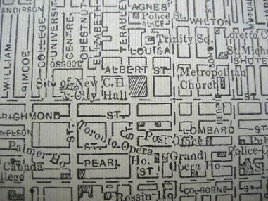
So, the photographer has made an error, or, perhaps the Registry was considered for the corner of Louisa, which was ONE block to the north.

There is no longer any trace of Louisa. It used to run from Yonge to Elizabeth. The access through the Eaton Centre from Yonge, across the south end of the Sears store and then past the south end of Trinity Church and the south end of the Marriott hotel traces the path of Louisa. As a kid I remember it as a very industrial and dark area. The Eaton factories loomed high on a couple of sides.

The one block from westward from Bay was renamed Hagerman at some point in history.

torontomapsegment.jpg
 
I'm reading the caption on the photo. The Registry building was at Elizabeth and ALBERT street. The site is now the west side of Nathan Phillips Square.

So, the photographer has made an error, or, perhaps the Registry was considered for the corner of Louisa, which was ONE block to the north.

Didn't the Registry building take up the entire block between Albert and Louisa?
 
I really enjoy that photo. If nothing else, one feels as though you are looking into a slice of everyday life that is lost to us. One can almost smell the dung in the road, coal smoke in the air, and so forth. Would that it was in Kodakrome colour.

Slight aside, am I alone in suspecting the cameraman asked the girl in the foreground to move several times, but then gave up in the face of 5 year old truculence or curiousity?
 
There is no longer any trace of Louisa. It used to run from Yonge to Elizabeth. The access through the Eaton Centre from Yonge, across the south end of the Sears store and then past the south end of Trinity Church and the south end of the Marriott hotel traces the path of Louisa. As a kid I remember it as a very industrial and dark area. The Eaton factories loomed high on a couple of sides.

The one block from westward from Bay was renamed Hagerman at some point in history.

Louisa actually ran south of that path through the Eaton Centre and Trinity Square. Probably about halfway between that path and Shuter Street.

Looking at old zoning maps from the 1960s, it looks like the stretch of Louisa west of Bay St. was realigned to the north with the construction of the new city hall, and probably renamed Hagerman at that time.
 

Back
Top