


M II A II R II K
Senior Member
The Colourful Buses of Seoul
February 24, 2011
By John Calimente

Read More: http://regardingplace.com/?p=11085#more-11085
Transit systems always want to paint their buses in matching colours so that riders can spot them easily. But what if different bus colours could tell you roughly where they are going? Seoul, Korea has done just that. It takes time to become familiar with a transit system, especially its bus routes. While rail has the advantage of being very legible - one can always see the directions that the rails are headed - buses are another matter. Transit systems try to help by providing route maps at stops, naming routes after their destinations or neighbourhoods they pass through, or through their route numbering system.
- In Vancouver, for example, buses with triple-digit route numbers leaving downtown and beginning with 24 are headed for North Vancouver, 25 to West Vancouver, and 13 to Burnaby. Surrey routes start with the number 3 and Richmond routes start with 4. But that’s rather obscure, rather like learning the codes on Coca Cola cans that tell you where and when they were produced. What bus systems really need is way to make their routing easily understandable even to those who have never ridden them before. I recently found out that Seoul, Korea has implemented a system that goes a long way towards solving the bus legibility problem.
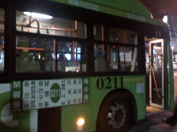
- The colouring scheme goes a long way towards helping riders know exactly where their bus is going. It’s very simple. Blue buses travel long distances on major arterial roads, serving more than 2 districts, and run in median bus lanes when they get close to the centre of the city. Green buses operate as feeder buses to the 8 lines on the subway system and are run by private companies. Red buses are express routes with limited stops connecting major suburban towns to the central city. And yellow buses are circular routes that travel between the major destinations in the central city. Blue and red buses are the same price, while the red (suburban) buses cost more and the local yellow buses less.
- No more worrying about which direction the bus is headed either (the fact that one can get on both a #17 UBC or Oak bus headed the same direction at the same stop must confuse a lot of first-time riders in Vancouver).
Instead of replacing the buses themselves, though, they went with a different approach that consisted of 5 key changes:
1) Bus routes were simplified
2) Four bus categories were created, each with a different colour scheme (red, blue, yellow, and green);
3) Route numbers were changed so that they explained both the origin and destination of the route, based on a district numbering system;
4) A flat-fare system was implemented and integrated with the subway system;
5) Real-time communication systems were installed so that transit riders could check arrival times by cell phone.
http://www.youtube.com/watch?v=chONjx_7ML0#t=5m05s
First they divided Seoul into 8 numbered zones, starting at 0 in the downtown core and giving the surrounding zones numbers 1 through 7. Then they used these zones as part of the route numbers.

Another smart thing that Seoul has done is to put the major destinations on the side of each bus
February 24, 2011
By John Calimente
Read More: http://regardingplace.com/?p=11085#more-11085
Transit systems always want to paint their buses in matching colours so that riders can spot them easily. But what if different bus colours could tell you roughly where they are going? Seoul, Korea has done just that. It takes time to become familiar with a transit system, especially its bus routes. While rail has the advantage of being very legible - one can always see the directions that the rails are headed - buses are another matter. Transit systems try to help by providing route maps at stops, naming routes after their destinations or neighbourhoods they pass through, or through their route numbering system.
- In Vancouver, for example, buses with triple-digit route numbers leaving downtown and beginning with 24 are headed for North Vancouver, 25 to West Vancouver, and 13 to Burnaby. Surrey routes start with the number 3 and Richmond routes start with 4. But that’s rather obscure, rather like learning the codes on Coca Cola cans that tell you where and when they were produced. What bus systems really need is way to make their routing easily understandable even to those who have never ridden them before. I recently found out that Seoul, Korea has implemented a system that goes a long way towards solving the bus legibility problem.
- The colouring scheme goes a long way towards helping riders know exactly where their bus is going. It’s very simple. Blue buses travel long distances on major arterial roads, serving more than 2 districts, and run in median bus lanes when they get close to the centre of the city. Green buses operate as feeder buses to the 8 lines on the subway system and are run by private companies. Red buses are express routes with limited stops connecting major suburban towns to the central city. And yellow buses are circular routes that travel between the major destinations in the central city. Blue and red buses are the same price, while the red (suburban) buses cost more and the local yellow buses less.
- No more worrying about which direction the bus is headed either (the fact that one can get on both a #17 UBC or Oak bus headed the same direction at the same stop must confuse a lot of first-time riders in Vancouver).
Instead of replacing the buses themselves, though, they went with a different approach that consisted of 5 key changes:
1) Bus routes were simplified
2) Four bus categories were created, each with a different colour scheme (red, blue, yellow, and green);
3) Route numbers were changed so that they explained both the origin and destination of the route, based on a district numbering system;
4) A flat-fare system was implemented and integrated with the subway system;
5) Real-time communication systems were installed so that transit riders could check arrival times by cell phone.
http://www.youtube.com/watch?v=chONjx_7ML0#t=5m05s
First they divided Seoul into 8 numbered zones, starting at 0 in the downtown core and giving the surrounding zones numbers 1 through 7. Then they used these zones as part of the route numbers.
Another smart thing that Seoul has done is to put the major destinations on the side of each bus
