News   GLOBAL  |  Apr 02, 2020
 8.9K     0 
News   GLOBAL  |  Apr 01, 2020
 40K     0 
News   GLOBAL  |  Apr 01, 2020
 5.1K     0 

kkgg7

Banned
Member Bio
Joined
Sep 9, 2011
Messages
920
Reaction score
0
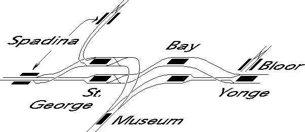
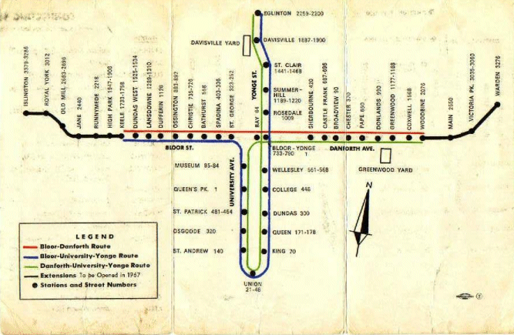
Current design of Toronto's subway line works pretty well in terms of integrating with the buses and streetcars. However, I have a question about the the west part of the YUS line. Essentially, why does the subway have to be on University Ave in downtown area? Considering University Ave 550 meters from Yonge St, a mere 5-6 minutes work, doesn't it make more sense to have the subway run on something a bit further way, such as Spadina Ave.

Spadina is 800 meters from University, still a less than 10 minutes walk, but only 650 meters from Bathurst (the west boundary "downtown"). I would think if the western branch runs on Spadina, more people will have direct access to it within 10 minutes of walking (from Palmerston/Tecomseth to Sherbourne, which most people can accept without transferring). People working on University Ave can easily take the Yonge line and walk for 5 minutes to work (many have PATH access), and on the other hand, Spadina and Bathurst will both have subway access, and the "downtown" core can be easily expanded.

I know it was meant to provide easy commute for financial district, but I just don't see the point of two parallel lines being 550 meters apart. I know many working on east side of University (MARS for example) simply get off the Yonge line (College St) and walk to office, instead of wasting 10 more minutes to make a U-turn.
 
Last edited:
Because University of Toronto is a large destination?

UofT will still get St George Stn, Queen's Park stn will be College/Spadina. Musem stn gives way to Harbord/Spadina. UofT gets a station on each corner of its campus. I don't see that to be a problem.
Right now, King and St Andrew is 550 m apart, kind of silly.

Or maybe because Queen's Park thinks it deserves a station? Of course it will be nicer if each main street gets a line, but given limited resources, wouldn't it make sense to make the best use of it by provide subway access to more people? I don't think folks working on University/King or University/College will suffer that much by walking 4 or 5 minutes every day.
 
If the University line was built today you'd probably be right. But the route was decided more than 50 years ago... when I'm guessing the densities near Spadina and Bathurst weren't quite what they are today. Nevermind that getting funding for the subway would've been much easier for a route running directly under Queen's Park.
 
If the University line was built today you'd probably be right. But the route was decided more than 50 years ago... when I'm guessing the densities near Spadina and Bathurst weren't quite what they are today. Nevermind that getting funding for the subway would've been much easier for a route running directly under Queen's Park.

You are probably right.
I did some research. The University Line was completed in 1963, from Union to St George. Most likely at that time, this is how big downtown is expected to be. The extension of this line was done in 1978, and I guess the city realized it would be stupid to extend it along Avenue Road, 500-600 meters west of Yonge, like what they did to the first segment. It went westward to Spadina/Dupont, Bathurst/St Clair etc.

However, even looking back, it is still short-sighted for the city of Toronto to expect the 600 meter stretch between Yonge st and University Ave will be how big Toronto's downtown is supposed to be. The planners should have had a bigger vision.

Addtionally, the line has only 1 station on Spadina (Dupont stn) and 6 on Allen Road. I seriously have no idea where the YUS name comes from.
 
The name of the Spadina portion of the line comes from the Spadina Expressway which was to be built at the same time as the subway but never materialized. You know it best by it's nom de voyage, Allen Rd. - After the Spadina Expressway was cancelled, the highway was called Allen Rd. (instead of the Spadina Expressway)
 
However, even looking back, it is still short-sighted for the city of Toronto to expect the 600 meter stretch between Yonge st and University Ave will be how big Toronto's downtown is supposed to be. The planners should have had a bigger vision.

They kind of did.
Another reason for the University line was to provide a downtown link from the western part upcoming Bloor-Danforth line (Keele) which was going to open 3 years later in 1966 and also (ironically) to relieve the Yonge line which was rapidly becoming crowded. I believe the University line and the Bloor-Danforth line were being constructed at the same time.

It seems the city was never short of great planning, just seldom could get over the political bickering to implement them. The Eglington crosstown, the DRL, the Queen line, if they all got constructed decades ago when it was much cheaper, we wouldn't have to talk about transit and congestion as much as we do now :p
 
Cities were differently sized 50+ years ago.

Also, if you think Yonge and University are too close, you better not visit Manhattan any time soon.
 
I did some research. The University Line was completed in 1963, from Union to St George. Most likely at that time, this is how big downtown is expected to be. The extension of this line was done in 1978, and I guess the city realized it would be stupid to extend it along Avenue Road, 500-600 meters west of Yonge, like what they did to the first segment.
Remember however, that the original plan, and original operation, of the line was that trains from Union heading up the University line, didn't stop at St. George. Half went to Keele,and half went to Warden (using Lower Bay station). It was never the original plan to extend the line up Spadina. The plan was to get a one-seat ride from the Bloor line and the Danforth line to downtown.

I'm quite sure that if they were to have done it again, they would have instead of extending from Union up University, they would have run to Spadina, (down Front, or King, or something), and then up Spadina all the way to the existing Spadina line. And also built Bloor-Yonge as a more appropriate interchange station.

Didn't the guy who designed the whole 1963-1966 expansion say that he would have designed Bloor-Yonge station completely different had he known how it would have been operated? Didn't he also lose his job over the the whole fiasco? Remember how underused the University line used to be before it got extended north of Bloor?
 
Remember that the Bloor Line and the Danforth Line were originally interlined with the University Line when they opened (trains from Danforth turned south down University; and trains from the Bloor west also turned south down University) - so they were intended to go to the same destination as the Yonge Line (downtown). The University Line was the connection to downtown (without relying on passengers transferring to the overcrowded Yonge Line) via the wye between St George and Bay Stations:

subway-5104-04.gif

http://transit.toronto.on.ca/subway/5104.shtml

When interlining was discontinued, the usefulness of the University Line dropped significantly (later passenger volumes were propped up by extending north along the Spadina Expressway RoW) and passengers primarily transferred at Yonge Bloor.

See James Bow's explanation here:

http://transit.toronto.on.ca/subway/5103.shtml

Excerpt:
The Bloor-Danforth line itself was to be built in two phases. The first section of the subway would be built from St. George Street east along Bloor Street and Danforth Avenue to Greenwood. The second phase would extend the line west to Keele Street, and move the eastern terminus east two stops to Woodbine Avenue. The second phase would open in 1969. Before all this was to be built, however, a connection was to be forged between the Bloor-Danforth Subway and the Yonge line. The first segment of this new construction would extend the Yonge line from Union Station north on University Avenue to join the future Bloor-Danforth line at St. George. In the TTC’s words, “The $45 million University line will give quick and convenient access to the commercial, financial, governmental and institutional organizations in the immediate area. Also, it will relieve rush-hour congestion at Bloor Station on the Yonge Subway by doubling the rapid transit capacity to and from the downtown area”.

At the time, ridership on the Yonge subway was starting to exceed expectations. Eight-car Gloucester trains which had been the exception became the norm. The TTC realized that suburban commuters using the Bloor line would have to transfer trains in order to continue trips downtown, and they realized that the Yonge subway south of Bloor would bear the brunt of that traffic if measures weren’t taken to alleviate it.

Here's the route map of the Bloor-Danforth and University Line when it was interlined (3 routes, one each colour). You could see that a passenger coming from the Bloor Line or Danforth Line would ride down University to the proper cross street and walk into downtown (i.e. Bay Steet) from the west instead of from the east (Yonge).

subway-5117-01.gif

http://transit.toronto.on.ca/subway/5117.shtml

from the article: The Truth About The Interlining Trial:
http://transit.toronto.on.ca/subway/5117.shtml
 
Last edited:
Cities were differently sized 50+ years ago.

Also, if you think Yonge and University are too close, you better not visit Manhattan any time soon.

No I don't think the two lines are too close. I think they are too close when there are so few lines in total. You need to make better use of what you have.
Manhattan has 20 something lines. Never too close if we get half of that. I would prefer a line on Keele, Dufferin, Bathurst, University, Yonge, Jarvis, Parliament, as well as Queen's Quay, Queen, College, Bloor, St Clair and Eglinton and still don't think they are too close. That will be half of the number NYC has.
 
Here's the route map of the Bloor-Danforth and University Line when it was interlined (3 routes, one each colour). You could see that a passenger coming from the Bloor Line or Danforth Line would ride down University to the proper cross street and walk into downtown (i.e. Bay Steet) from the west instead of from the east (Yonge).

That's really a very interesting design. I don't remember any other city has subways running like that.
However, that planning was still based on the wrong assumption that everyone eventually goes and only goes to downtown Yonge. other subway lines only serve the purpose of bringing people to lower Yonge st. Maybe at that time it was a valid assumption, but apparent, it lacks vision about how a city might expand and evolve., which leaves us an awkward situation: even the vibrant King West, Queen West as well as Chinatown are not within a short walking distance to a subway station.

that being said, it is still a good idea to extend the Spadina line southward below Bloor, and make 4 stops at College, Dundas, Queen, King, and merge with the DRL at Lower Spadina Station.
 
Last edited:
]Maybe at that time it was a valid assumption, but apparent, it lacks vision about how a city might expand and evolve., which leaves us an awkward situation: even the vibrant King West, Queen West as well as Chinatown are not within a short walking distance to a subway station.

Ummm no. The "vibrant neighbourhoods" you are talking about were empty industrial wastelands for decades after the University line was built. When the University subway was built Chinatown wasn't even on Spadina. It was clustered around St. Patrick station.

Here's a pic of the "vibrant" King West a decade after the subway opened. How it became a vibrant neighbourhood 30 years later has nothing to do with subways or transportation planning at all. It was due to marco economic trends and a rare instance of insight in our elected leaders.

john.jpg


Claiming things would have turned out better today if something was done different 50 years ago is stupid. Leave playing master of temporal causality to the experts.

endgame1.jpg
 
Last edited:

Back
Top