I would say it with a bit less hyperbole: Assuming Eglinton is extended to Pearson at one end, and east of Kennedy at the other, and assuming the ridership reaches a point where frequent 3-car LRV trains are used, the Mount Dennis MSF will not have enough car storage or maintenance capacity left to support a Jane LRT line. Jane will have to be serviced from Finch, or from a new facility.

- Paul
1642027754745.png
From link.

As mentioned earlier (see link), HALF of the capacity will be used at initial opening. Once the LRT is extended, they will not need the 15 bus bays anymore and the bus bays will be reduced in number, which will result in more real estate made available, should they need it. As seen in the above image, there is also room available for more track expansion at the Mt. Dennis facility, which is currently grass or dirt.
 
I would say it with a bit less hyperbole: Assuming Eglinton is extended to Pearson at one end, and east of Kennedy at the other, and assuming the ridership reaches a point where frequent 3-car LRV trains are used, the Mount Dennis MSF will not have enough car storage or maintenance capacity left to support a Jane LRT line. Jane will have to be serviced from Finch, or from a new facility.

- Paul

If Eglinton East gets built, there will be another facility somewhere in Scarborough. That facility can hold some of the ECLRT trains, in addition to the Eg East trains.

In that case, Mount Dennis might still have room for the Jane LRT trains.
 
View attachment 374488From link.

As mentioned earlier (see link), HALF of the capacity will be used at initial opening. Once the LRT is extended, they will not need the 15 bus bays anymore and the bus bays will be reduced in number, which will result in more real estate made available, should they need it. As seen in the above image, there is also room available for more track expansion at the Mt. Dennis facility, which is currently grass or dirt.
What routes are going to disappear?

The routes/route directions going to Mt Dennis are:
27 Jane South
32 Eglinton West
34 Eglinton
35 Jane
71 Runnymede (northbound)
71 Runnymede (southbound)
89 Weston Rd (northbound)
89 Weston Rd (southbound)
161 Rogers Rd
168 Symington
170 Emmett
171 Mt Dennis (northbound)
171 Mt Dennis (southbound)
935 Jane Express (southbound)
935 Jane Express (northbound)
989 Weston Rd Express (northbound)
989 Weston Rd Express (southbound)

Now rearrange this into 13 bus bays, 2 reserved (This is a possible bus bay assignment, don't consider this official)
Westwards
(1) 32 Eglinton West
(2) 170 Emmett
(3) 35 Jane
(4) 935 Jane Express NB
(5) 27 Jane South
(6) 935 Jane Express SB
Northwards
(7) 89 Weston Rd NB/989 Weston Rd Express NB
(8) 71 Runnymede NB/171 Mt Dennis NB
Southwards
(9) 89 Weston Rd SB/989 Weston Rd Express SB
(10) 71 Runnymede SB/171 Mt Dennis SB
(11) 161 Rogers Rd
(12) 168 Symington
Eastwards
(13) 34 Eglinton
Reserved
(14) Unloading
(15) Unloading/Wheel-Trans


Only Jane routes would disappear. The 32 and 170 would stay since Eg West is now a "subway". I suppose the 989 Weston Rd Express would become an all-day service by 2030 and move to their own bus bays. The 171 Mt Dennis southbound towards Jane/Alliance can get it's own bay. A new route could be introduced to take up another bay. So the bus terminal isn't going to be empty once the Crosstown is extended.
 
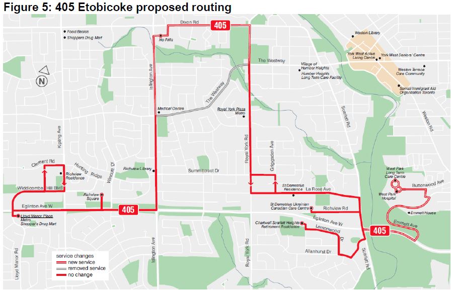
You forgot the 405 ETOBICOKE community bus. Could be re-routed at first to serve the Mt. Dennis Station, then re-routed again to have a possible on-street transfer at the Jane/Eglinton Station. Could keep the Mt. Dennis Station transfer so that the 405 will be able to connect with the GO/UP station there.

405etobicoke_map.jpg
From link.

See link.
 
Last edited:
View attachment 374618

How is this so far along that I missed all the steps leading to a TBM being assembled in an already dug trench!?

The LRT extension is being tunnelled under the 427/401/Eglinton interchange because there is a graveyard located there. Shh. Be very, very quiet. The light rail vehicles must not disturb the residents there. See the problems with the North Yonge Extension into Richmond Hill with the Holy Cross Cemetery.

A cemetery nestled in a highway interchange provides a noisy final resting spot.


From link.

20121029freewayshot.jpg


It seems like a strange location for a graveyard. Tucked within the massive interchange of Highways 401 and 427, Richview Memorial Cemetery stands calmly amid the traffic chaos surrounding it. The heritage site provides the final resting place for members of western Etobicoke’s pioneer farming families.

History​


Though burials were made onsite as early as 1846, Richview wasn’t officially a graveyard until the Union Chapel was completed, around 1853. According to a historical plaque, farmer William Knaggs (who is buried at Richview) sold the land that became the cemetery for use as “a chapel and lot without belonging to any particular church or denomination, to be respectively devoted exclusively to religious purposes in the discretion of certain trustees.” The church, which evolved into Richview United Church, moved south of the cemetery in 1888 and remained there until the nearby stretch of Highway 27 was converted into an expressway during the 1950s.

While the church relocated west of the future Highway 427, cemetery trustees resisted calls to move the graveyard, which led to its odd present-day positioning. The site was filled out with even more remains during the 1970s, as graves were moved from two other former Etobicoke cemeteries: Willow Grove Burying Ground (which was located at Kipling Avenue and Rexdale Boulevard) and McFarlane Family Burying Ground.

Around 300 people are estimated to be buried in Richview, of which only 90 have markers. Only descendants of those resting there can buy plots. The most recent burial was Victor Kimber, who maintained the grounds for over 40 years before he died in 2005.
20121029entrance.jpg

Grounds​


Finding the entrance is tricky if you aren’t paying attention. A hidden driveway runs south from Eglinton Avenue, just west of the exits from the surrounding highways. The road leads to a high, gated fence, which may or may not be locked when you arrive.

Don’t expect a tree-shaded vista: grass and shrubs provide the only hints of greenery. What you will see are plenty of century-old tombstones mixed in with historical plaques telling the cemetery’s story.

As a 2010 instalment of Ask Torontoist noted, exhaust fumes from neighbouring traffic are damaging the tombstones. Restoration efforts have included mounting markers onto new slabs. The graveyard no longer appears to serve as a dumping ground for construction refuse, though.
20121029dixon.jpg

Notable Names​


At least one family name is recognizable, if only because of the Etobicoke road named after them: Dixon.
 
Well if you ignore the Conservatives filling in the start of the first phase of the Eglinton West subway last century ... :)
True but that will never get passed Black Creek in a long time. What knows what would have happened if that was built. The Crosstown MSF land might be a huge development site if it didn't become a subway yard.

I mean a tunneled "subway" was never recommended recently till 2019. We knew Scarborough is going to be a tunnel since the Rob Ford era.

Timeline:
80s - Busway
90s - Eglinton West Subway Technology, conceptional - unknown if tunneled, trenched or elevated
2008 - Crosstown LRT, surface LRVs in medium
2014 - SmartTrack, EMU trains in trench option to be explored
2016 - Reverted to surface LRT extension
2017 - Council voted to explore grade separation at main intersections
2018 - City staff recommends no grade separation, surface only
2019 - Ontario takes over and declares a subway to be built
2020 - TBM tunnel option is recommended
 
I mean a tunneled "subway" was never recommended recently till 2019. We knew Scarborough is going to be a tunnel since the Rob Ford era.
I don't think they'd even done the studies to finalize the mode in 2016 - let alone announced anything. Where in the 2016 announcement does it say it's going to be on the surface?

As for Scarborough - I thought it was in the Rob Ford era, that they were looking at going surface and elevated up the SRT alignment, and not doing a tunnel at all. Though all the various options - many of them approved and funded - are tough to keep track of! :)
 

Back
Top