If you were Bussin it would be none of your business.

Why? Did she leave Toronto after she lost the election? That might not have been her ward, and she may not be a councilor anymore, but so long as she still lives in Toronto it's her business as much as it is anyone else's.
 
Lets get some sort of Frank Gehry project down there - doesn't matter whether its residential, commercial or institutional. It would create a focal point.


franksimpsons5.jpg


:D
 
From the NP, and their merry article, "Doug Ford The Idea Man".

In a sit-down interview with the National Post this week, he prefaced an unheard-of scheme with “now, this is way out there.â€

“If we have the privilege of getting a football team, we need a stadium,†the Etobicoke city councillor began, while sitting in City Hall’s cafeteria. Forget about putting it in the Port Lands. Why not take the infill from tunneling a transit line under Eglinton Avenue and “pull a Dubai,†he says, building a lollipop-shape land mass from the mainland into Lake Ontario, precise location undetermined, on which a new football stadium could sit.

He sketches it out on a reporter’s notepad, marking lines around the circular island stadium to illustrate lakeside bars. “So you have tailgating on the boats, and a massive dock all the way around. And a big parking lot here,†he says, drawing a rectangle on the mainland.

“Anyone who scanned Toronto and saw this magnificent stadium in the middle of the lake — well, not really in the middle but a quarter-mile out — they would look out and say, that’s Toronto,†he says. “It would be a big dream€¦ but what a sight.â€
 
These are the first genuine Ford plans released and they do seem to retain a lot of park land and flood plain, while maintaining the highly desired mix of housing, retail and public space. That a mall might be in the center of it doesn't have to be a bad thing if executed properly. It doesn't look like it's anywhere close to the lake itself and there doesn't appear to be an expanse of parking lots around the mall either.

How can you tell if there is parking lots surrounding the mall? If they retain a similar amount of park and flood plain why not keep the existing plan and modify the zoning on the non-park lands to allow greater retail? Why does a mall need to be in the waterfront at all considering shopping for most people requires a vehicle to load crap into and the portlands aren't that accessible by car compared to suburban mall locations and even for transit users will not be as accessible as Eaton Centre?

We need to see what sort of street grid they have in mind, rather than just colored area descriptions.

No we don't. We can see that it throws out all the work done to date and that is all we need to know.

It would be nice if the Events Quay somehow emulated Pritzker in Chicago, in terms of some redeeming architecture and public event/gathering space.

Pritzker has free concerts in a public park. Why would a private developer want to build that? Waterfront Toronto might want to build that but there is no reason for a private developer to.

I don't think the Ford's care about the actual architecture itself and seem content to let those who know better influence that (ie: Sterling and Kuhne), they just want to get it moving more than anything else, and are willing to include feature elements that help finance it.

I think you are right about them not caring about the actual architecture itself but why would you suggest there is going to be any oversight from those who know better?

Still not a fan of the ferris wheel, but the islanders will be happy that it basically eliminates the noise from the Docks.

What events do you think are going to happen at Events Quay?
 
No we don't. We can see that it throws out all the work done to date and that is all we need to know.
That's just it - it doesn't throw everything out. They have specifically said that it builds on the work that has been done. That's why we have to see what resemblance it may or may not have. If it's very similar to what was previously envisioned then its not the complete and total departure that it's being painted out to be.

Pritzker has free concerts in a public park. Why would a private developer want to build that? Waterfront Toronto might want to build that but there is no reason for a private developer to.
I said emulated, not copied exactly. Are you saying Pritzker offers nothing to the city and visitors other than free concerts?

I think you are right about them not caring about the actual architecture itself but why would you suggest there is going to be any oversight from those who know better?
Um - because they've actually consulted and/or hired people who know better? Sterling was instrumental in the PanAm and West Donlands work - widely praised around here - so it's not like the guy is going to recommend plunking Atlantic City down there.

What events do you think are going to happen at Events Quay?
Food festivals, cultural/ethnic gatherings, public markets, concerts, even Cirque. Whatever they are, they won't be going until 3am for 3 days every weekend like the nightlcub does.


Can somebody please tell me why Doug Ford is in PRIVATE talks with a developer, in a ward which is not his own? He was elected to represent Etobicoke, so what right does he have to go behind the back of the democratically elected council member of that ward? I just think that's so wrong. If I was Bussin, I'd be fuming. Why is she not going ballistic that this guy is not only taking over her ward but doing it behind closed doors?
This has been explained before, but he's Vice Chair for Build TO. It would be his job to deal with potential developers for city owned property in every ward. He's not signing contracts here, he's creating interest and bringing potential partners to the table. It's his job.
 
Last edited:
It is not his job at all. Let alone to do in the overall context of getting control of this piece of land from Waterfront Toronto, and selling it off under the aegis of himself and his brother.

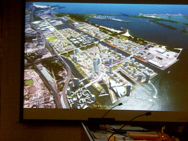
Regarding Councillor Ford: The Portlands properties he's after are not listed as being any of BuildTO's properties. BuildTO is not in charge of the properties currently under the aegis of Waterfront Toronto.
http://www.buildtoronto.ca/

Mayor Ford has a seat on the board of Waterfront Toronto. It's hard to find a former map of what's was what regarding federal, provincial and city-owned properties, but since all that property has been ceded to Waterfront Toronto to be developed under all three levels of government, that's no surprise.

Since the properties ceded to WaterfrontToronto are not only out of Councillor Ford's ward but out of his company, his reach and his expected interest, his visionary backroom meetings with developers are not business as usual.
Power regarding those lands are in his brother's jurisdiction, though. Obviously, they talk.

The Fords are confusing people, because they amplify and mirror each other - and make natural checks on co-influence seem superfluous - or impossible to enforce. They've admitted to using their familial closeness as part of their means to get around obstacles, and I'd say they're using it to great effect. Certainly the press is helping. When Doug speaks, he's treated perceptually, publically like the Mayor. Which confirms him as part of the Mayoralty. Which he isn't, but familiarly is. This is all peculiar and a strikingly weird.
 
Last edited:
That's just it - it doesn't throw everything out. They have specifically said that it builds on the work that has been done. That's why we have to see what resemblance it may or may not have. If it's very similar to what was previously envisioned then its not the complete and total departure that it's being painted out to be.

It is a total departure. Sure, they are leaving West Don Lands and Bayfront in tact... there are already signed contracts for that. On the Port Lands / Lower Don Lands they are throwing out the plan. None of that plan can be usable if the river is not naturalized and the river makes a 90 degree turn at Keating Channel. What aspect of the current plan can they use if the layout of the land is entirely different? They are saying it builds on the work done because it would sounds like the waste of money it truly is otherwise.

I said emulated, not copied exactly. Are you saying Pritzker offers nothing to the city and visitors other than free concerts?

Millennium Park is a public park and central to that concept is being free. Pritzker pavillion is the outdoor concert venue in the park. The value of the park and the concert venue are the design of the space and their free events. Key to the success of the park are the 500+ free events per year. Pritzker doesn't add much to the city beyond its architecture and free concerts.

Um - because they've actually consulted and/or hired people who know better? Sterling was instrumental in the PanAm and West Donlands work - widely praised around here - so it's not like the guy is going to recommend plunking Atlantic City down there.

Let's hope that is true. Unlike Waterfront Toronto where there is evidence of the design review process there is nothing to ensure Toronto Port Lands does anything that is recommended by the architects. Many projects around the world have had well meaning architects overruled by developers that cut corners and build whatever they want anyways. Considering Sterling is saying that the plan builds on the existing plan despite the whole design competition about the Don watercourse being the focus of the design competition means I don't really trust him. I mean if he plays his cards right with the Ford brothers the work of other architects gets thrown out and his plans rule the waterfront. How unbiased is that? With the Toronto Waterfront design review it isn't a biased one man show, it is a group of people.

Food festivals, cultural/ethnic gatherings, public markets, concerts, even Cirque. Whatever they are, they won't be going until 3am for 3 days every weekend like the nightlcub does.

I'm going to guess that concerts and noisy events are just as likely as noise from the Docks. If you want to convince yourself the events quay will have identical programming to Harbourfront Centre then be my guest. I'm going to guess that with Cousins Basin lined with Cafes and Restuarants and and Events Quay below a ferris wheel will be no more quiet than the Docks. Not that it matters to me really, but pitching this plan as something the cottagers should get on board with is rich. The original plan would have park along the waterfront.
 
On the weekend I sent an email to the Toronto Portlands Company to ask why the rail line was being repaired and they just phoned me to say it was 'regular maintenance". They agreed the line was seldom used but said it served the Toronto Port Authority's docks to the west of Cherry Street. Still seems like odd timing to be rehabilitating this line as it clearly hasn't seen a train for many years.
 
This just all seems so absurd and such a joke. I kind of want to see other councillors start recommending grand projects for Etobicoke.


From: http://www.theglobeandmail.com/news...rt-lands-faces-big-challenges/article2154245/

"Councillor Doug Ford’s new development scheme for the Port Lands risks a significantly revised environmental assessment, throwing into doubt the promised six-year timeline for his project while potentially adding millions of dollars in additional costs, according to several lawyers familiar with the regulations.

Mr. Ford also faces the possibility of an investigation by the city’s lobbyist registrar over private meetings with representatives for the Westfield Group, an Australian shopping-mall developer. The Globe and Mail has learned that Paul Magder, a resident of the former city of York, is filing a complaint today, alleging that the company didn’t disclose its lobbying activities.

Mr. Ford’s tourist-friendly vision for the Port Lands, to be formally unveiled Tuesday at city hall, involves a mega-mall, hotels, a giant Ferris wheel and a monorail. It diverges sharply from Waterfront Toronto’s current plan, which calls for the naturalization of the mouth of the Don around a newly created delta surrounded by medium-density neighbourhoods, instead of forcing the river to turn west into the Keating Channel."
 
None of that plan can be usable if the river is not naturalized and the river makes a 90 degree turn at Keating Channel.
I'm just curious, but can someone in the know explain if it's geologically necessary for the river to make the 90 degree turn, or was it simply the overall feel of the land usage that determined the turn? If they allow for the same amount of flood plane but arrange it in a different manner, could it still accomplish the same thing in terms of flood protection and providing the greenspace and parkland desired?

This is why I say we need to see the street grid. Until they show their thoughts in more detail, it leaves people to fill in the blanks with their best/worst scenarios. It leaves it open for people to assume the dark blue area is the mall and the light blue area is a big parking lot, even though the description implies otherwise. If the contents of the land are largely the same but rearranged, it's certainly a change in course but not a 'total departure'.

Did the public feedback specifically say "we want the flood plain to run east-west" or something?
 
I haven't agreed with much that StCatharinesCitizen has posted, and have my doubts about the whole Harvard thing - but the sneering that you guys are engaging in more or less negates any positive arguments you're trying to make. It's embarrassing, really, the way the group think manifests itself among the spoiled, self righteous blowhards on here.

Sorry, man -- this is what happens when people claim qualifications. This is an anonymous message board -- you just can't do it without sounding like an ass.
 
None of that plan can be usable if the river is not naturalized and the river makes a 90 degree turn at Keating Channel.
I'm just curious, but can someone in the know explain if it's geologically necessary for the river to make the 90 degree turn, or was it simply the overall feel of the land usage that determined the turn? If they allow for the same amount of flood plane but arrange it in a different manner, could it still accomplish the same thing in terms of flood protection and providing the greenspace and parkland desired?

This is why I say we need to see the street grid. Until they show their thoughts in more detail, it leaves people to fill in the blanks with their best/worst scenarios. It leaves it open for people to assume the dark blue area is the mall and the light blue area is a big parking lot, even though the description implies otherwise. If the contents of the land are largely the same but rearranged, it's certainly a change in course but not a 'total departure'.

Did the public feedback specifically say "we want the flood plain to run east-west" or something?


Sorry, man -- this is what happens when people claim qualifications. This is an anonymous message board -- you just can't do it without sounding like an ass.
Oh I have no problem with someone being called out on claims that seem to run counter to what they're saying - it should be done, actually - but it can be done without sounding like an even bigger ass, otherwise both people lose their claim to any sort of moral superiority. I think you know that my post was about far more than just the way SCC was questioned, though - it was about this forum and group-think in general that results in people being bullied by the very same posters who claim to be voices of fairness and logic. Their credibility is lost when they turn into the kind of goons they claim to oppose.
 
Last edited:
I'm just curious, but can someone in the know explain if it's geologically necessary for the river to make the 90 degree turn.

The river used to run out into a marsh so did not end at a concrete wall and a 90 degree right turn. Wikipedia says:

In the late 19th century, a public works program was started to straighten the lower part of the Don River south of the Winchester Street bridge. The project was called the Don Improvement Project. The goal of the project was to alleviate floods on the lower Don that were periodically washing out bridges. It was also done to create additional wharf space for the Toronto harbour. When it was completed, the river was directed south into Ashbridge's Bay.

At the time Ashbridge's Bay was still a lacustrine marsh. It was heavily polluted by local industry. The water from the river was diverted into the bay with the hope that it would flush the bay of the poor water. However the flow of water introduced raw sewage in the river into the bay. The bay water remained stagnant and was increasingly becoming a serious health risk. The Keating Channel was proposed as a method of directing the dirty river water into the harbour thus dispersing it more rapidly.

Initially the channel was planned to go from the northeast corner of the inner harbour east towards Leslie Street and join up with the Coatsworth Cut. However, the portion east of the Don River was never completed and it was closed in 1916. The channel was completed in 1922 after 8 years of construction. The completed channel now runs from the harbour east to the mouth of the river, a distance of about 800 metres.


At present, if there were a major "rain event" the river would overflow south of the rail line and the Gardiner and flood the Portlands area (and probably further east too.) Until the West Don Lands berm was finished, recently, the river would also have flooded westwards north of the rail tracks.
 

Back
Top