Register123
Active Member
Please, please, I beg no BSN2.
^ Guys, I am able to catch most of your acronyms, but what is BSN2? Thanks.
the central city will continue to rise over the coming decades. The wealthy protected neighbourhoods to the north (Rosedale, South Hill, The Annex, Cabbagetown), Lake Ontario, and the Don Valley will all act as barriers to expansion of the core which may actually lead to your desired effect, Steveve. Yonge & Eg and North York will also probably continue to go skyward
Casa2 is gonna really dominate the area. Apparently there's gonna be a BSN2 as well? And the Scientologist building--on watch for a giant proposal....
Bloor Street Neighbourhood 2
Yeah, the Don Valley, the Lake, and the Rosedale Ravine kind of form defined boundaries of downtown. The only area that's vague is to the west. Is it Spadina? Is it Bathurst? There's no really defining geopgraphical feature that defines the edge. In a lot of cases, streets are kind of arbitrary borders. It would definitely be cool to see the high rise development extend further east all the way to the Don Valley though.
High Park perhaps? Up to Bloor Street at least?
The difficulty with defining the boundaries of "downtown Toronto" would not be dissimilar to the difficulty of defining that of downtown/lower Manhattan. At the end, it's all arbitrary.I think that's a bit too far west. If you're going to go that far west, might as well do the Humber River. A lot of people are starting to see downtown Toronto as kind of a mini-Manhattan, and one of the things that makes Manhattan Manhattan is that it has very defined edges (from geography, obviously). There's no debate as where Manhattan begins and ends. Downtown Toronto is geographically closed off on 2.5 sides (half the north side is by the Rosedale ravine, half isn't), but the 1.5 sides that it isn't closed on kind of ruins the "dense island" effect. Not that that's a bad thing, I'm just saying it makes it harder to pin down exactly what is "downtown", and how far west these high rises should be stretching.
I think that's a bit too far west. If you're going to go that far west, might as well do the Humber River. A lot of people are starting to see downtown Toronto as kind of a mini-Manhattan, and one of the things that makes Manhattan Manhattan is that it has very defined edges (from geography, obviously). There's no debate as where Manhattan begins and ends. Downtown Toronto is geographically closed off on 2.5 sides (half the north side is by the Rosedale ravine, half isn't), but the 1.5 sides that it isn't closed on kind of ruins the "dense island" effect. Not that that's a bad thing, I'm just saying it makes it harder to pin down exactly what is "downtown", and how far west these high rises should be stretching.
our different geography, scale, history, climate & culture are all good reasons to not look at toronto as a "mini manhattan" but rather as a changing 21st century toronto. Why do these people you speak of only envision a second rate version of someone else's city when they could direct their energies, ideas and talents towards creating a first-rate version of their own city? This has always bothered me.
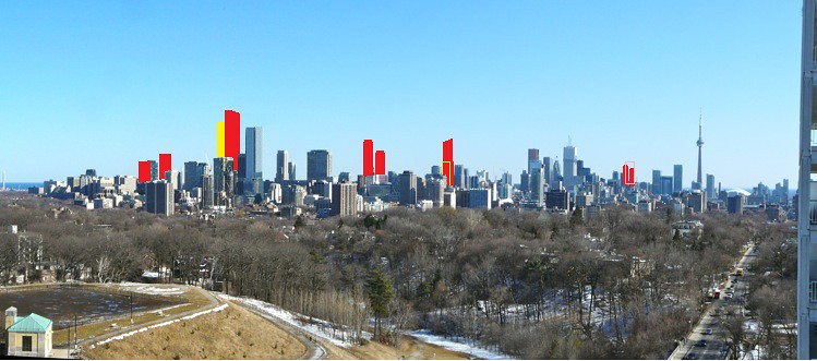
Is there a higher-res image of this skyline shot anywhere?
Imagine this view with Ice Aura and Bloor....And Shangri La....it will aslo have a large impact
Traynor, could ya do a Quick render with those projects??? even a line drawing, so I can see where they'll be. Ice would be behind SL..correct?? 1 Bloor behind 4S?? Burano too?? That will be a great skyline view in 5 years /!!

Thanks for that Traynor...Five (46s) and 9-Grenville (52s) might also add some height to that.