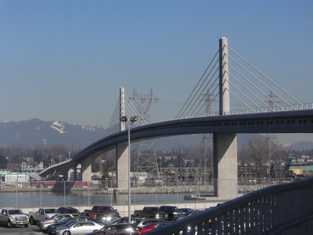
Why do the tracks come above ground and stop right before Dufferin? That would effectively make any kind of westwards expansion impossible. There will be a need for another north-south line to connect here, guaranteed.
Not true. There is definitely more than enough space there to either elevate the tracks above the rail line, to have the tracks follow the rail line, or worst case scenario, go back underground again. Metrolinx specifically mentioned that they are designing the line to be easily extendable west and/or north after opening.
 

This study is entitled an "Environmental Conditions Report",
so it is not a "Environmental Project Report (EPR)" which is the report that assesses impacts of the project.
This looks like a preliminary report providing a background review of existing site conditions
and is likely to assist prospective proponents in preparing their bids for the project so they all have the same information.


The Study Area in that report tells us that the new bridge will be west of the Leaside/Millwood Bridge, and
there is a lot of flexibility in the area north of Overlea Blvd for the allignment and connection to the yard.
 
Last edited:
Still thinking that this sort of allignment is possible in the Thorncliffe Park area,
maybe with the valley crossing to Don Mills a bit farther north to shorten the bridge.

WRT the Thorncliffe Park alignment, is it possible to divert the line from Overlea across the Costco parking lot to the hydro RoW then across the valley? SkyTrain in Burnaby cuts across a Home Depot parking lot the same way.

Stations would be located on the mall parking lots allowing for cheaper "side-of-road" configurations instead of median stations which require mezzanines and have to be taller.

This is what I could see based on the way SkyTrain has been fit into the urban fabric in Metro Vancouver.
It would also explain why Metrolinx would be in discussions with stakeholders - for station sites and rights-of-way.

That would also put the line next to the proposed Maintenance and Storage Facility site with a short spur.

This is the alignment that makes sense to me:

wFDj7Bt.png


SWI64EK.png


0KOb3nz.png

 
I'm confused. Do you call the TTC cheapening out for targeting 2-minute headways with ATC? What matters here is capacity. If they built it with 90-second headways and 100m trains, the Ontario Line will have a higher future 'no construction needed' capacity than Line 2. Old style trains simply cant stop and accelerate/clear stations fast enough to reach 90-second headways without passenger discomfort. Only shorter trains can do that. I wouldn't call that cheapening out. It's simply a different way of achieving the same thing.

About burying lines, that is simply the political will of the day — a completely separate topic. The guideways that would handle TR trains are much bulkier than what new systems use, and the legacy subway rolling stock cant handle steeper grades.

Arbitrary design capacity is different from ultimate capacity, which is limited by the sizing of built infrastructure. TTC has the potential of further increasing the throughput of the current system by the way of increasing frequency, new trainsets (more efficient seating arrangements; possible 7th car) and modifications to in/egress at chokepoint stations; OL as proposed with the limited platform length simply have limited room for further improvements - you will simply have more difficulty pushing a system further before hitting that brick wall that is sizing of physical builds. We have seen that at Canada Line .

As to elevating lines - as you have identified it is political will, not technology that is the issue here. The so called plus of OL styled trains is a relative non-issue.

Could be supplemented with additional relief lines instead of longer trains on one line.

That strategy can be limited in effectiveness due to intensification and impact of future extension of the existing line. Yonge line is facing that problem - it isn't merely sufficient to relieve it by building a new line - it is necessary to improve on the current capacity due to the projected demands on the line even when the RL is in place.

AoD
 
Last edited:
WRT the Thorncliffe Park alignment, is it possible to divert the line from Overlea across the Costco parking lot to the hydro RoW then across the valley? SkyTrain in Burnaby cuts across a Home Depot parking lot the same way.

Stations would be located on the mall parking lots allowing for cheaper "side-of-road" configurations instead of median stations which require mezzanines and have to be taller.

This is what I could see based on the way SkyTrain has been fit into the urban fabric in Metro Vancouver.
It would also explain why Metrolinx would be in discussions with stakeholders - for station sites and rights-of-way.

That would also put the line next to the proposed Maintenance and Storage Facility site with a short spur.

This is the alignment that makes sense to me:

wFDj7Bt.png


SWI64EK.png


0KOb3nz.png


So this site is available? Looks like it was recently cleared?

20200917_195333.jpg
 
Still thinking that this sort of allignment is possible in the Thorncliffe Park area,
maybe with the valley crossing to Don Mills a bit farther north to shorten the bridge.

That alignment has some consequential challenges.

That valley is the Gatineau Hydro corridor.

I don't see Hydro one allowing anyone to run under or over their towers, and I expect there's a minimum clearance to the side as well.

Assuming one could get around those challenges, portions of that landscape are environmentally sensitive and constructing supports in them would be very damaging.

The alignment would also likely pass directly over a community garden (one of the largest in the City); and also a cricket-pitch/school yard that the community fundraised to build.

Also, dropping people in the Costco parking lot would be highly inconvenient for area residents whose homes are all south of Overlea, and either east or west of this location (on Thorncliffe Drive).

****

I should add, Toronto is pushing hard against the Leaside MSF, the challenges of which I explained earlier in the thread.

I find it stretches credibility that this will be the location of said facility, though it does remain possible.
 
The Sydney Metro is actually a commuter rail line that is using metro/subway rolling stock. It replaced a line that had bi-level trains, and the stations are spaced in such a way that would make the old 1-stop Scarborough subway plan blush.

I'm confused. Do you call the TTC cheapening out for targeting 2-minute headways with ATC? What matters here is capacity. If they built it with 90-second headways and 100m trains, the Ontario Line will have a higher future 'no construction needed' capacity than Line 2. Old style trains simply cant stop and accelerate/clear stations fast enough to reach 90-second headways without passenger discomfort. Only shorter trains can do that. I wouldn't call that cheapening out. It's simply a different way of achieving the same thing.

About burying lines, that is simply the political will of the day — a completely separate topic. The guideways that would handle TR trains are much bulkier than what new systems use, and the legacy subway rolling stock cant handle steeper grades.

Agreed. What matters is capacity.

The highest capacity option is what was already planned for the DRL South. Now they're cheaping out on the one project that can't afford it.
 
I think the idea of the Ontario Line is great, and I'm wholly excited for it. But one part of me questions the value of it if GO Expansion goes ahead, given it generally offers the same service area, at least until Pape/Gerrard. Why not just expand the Richmond Hill line and include it in GO Expansion? You could have some cool stations in the Don Valley with some crazy elevators or something, all for probably 1/10th of what this will cost.
 
I think the idea of the Ontario Line is great, and I'm wholly excited for it. But one part of me questions the value of it if GO Expansion goes ahead, given it generally offers the same service area, at least until Pape/Gerrard. Why not just expand the Richmond Hill line and include it in GO Expansion? You could have some cool stations in the Don Valley with some crazy elevators or something, all for probably 1/10th of what this will cost.
I believe the issue is the Richmond Hill line would require something like a Billion dollars in flood mitigation work to include it in the GO RER plan. That's quite steep for a line that doesn't really have the ridership to justify what RER is offering. As well beyond the union corridor you could only maybe squeeze a station in around Dundas (Regent Park). North of that the line becomes inaccessible in any sensible manner until Leslie and Sheppard. (As an aside I do believe investing in Batter/Electric Trains or even just DMU's for the Richmond Hill Line would be worth while for the GO RER project).
 
That alignment has some consequential challenges.

That valley is the Gatineau Hydro corridor.

I don't see Hydro one allowing anyone to run under or over their towers, and I expect there's a minimum clearance to the side as well.

Assuming one could get around those challenges, portions of that landscape are environmentally sensitive and constructing supports in them would be very damaging.

The alignment would also likely pass directly over a community garden (one of the largest in the City); and also a cricket-pitch/school yard that the community fundraised to build.

Also, dropping people in the Costco parking lot would be highly inconvenient for area residents whose homes are all south of Overlea, and either east or west of this location (on Thorncliffe Drive).

The hydro corridor might be an issue, but lines could be raised if necessary.
The SkyTrain shown in the Home Deport parking lot segment actually goes under a BC Hydro transmission line as well, so that's probably an access issue, not a proximity issue.
PzkU3HY.png


The Canada Line North Arm Bridge is also near some transmission towers:
KICX9912.jpg


The columns and bridge towers could be placed to minimize impact on environmentally sensitive areas.

There are community gardens under Vancouver's SkyTrain guideway, so the uses are not incompatible.
ccg.jpg


I was thinking that the station would be on the Food Basics mall parking lot south of Overlea - that site would be ripe for transit oriented redevelopment - like Burquitlam Station in my post.
 
Last edited:
The hydro corridor might be an issue, but lines could be raised if necessary.
The SkyTrain shown in the Home Deport parking lot segment actually goes under a BC Hydro transmission line as well, so that's probably an access issue, not a proximity issue.

PzkU3HY.png


The columns and bridge towers could be placed to minimize impact.

There are community gardens under Vancouver's SkyTrain guideway, so the uses are not incompatible.

ccg.jpg


I was thinking that the station would be on the Food Basics mall parking lot south of Overlea - that site would be ripe for transit oriented redevelopment - like Burquitlam Station in my post.

A thoughtful counterpoint.

The impact on the community garden would be (mostly) about light; the level of impact would depend on orientation relative to the sun and adjacent buildings.

Passing under a corridor directionally vs running under one would likely have a different risk profile but also a different impact in term of maintenance access.

That said, I accept that a short-run underneath, subject to clearance might get a pass.

Though, anyone who lived through negotiations btw Hydro and the City over parks uses...........might wonder.

Looking the current line level............I can't see going under working.

But yes, they could be moved; though that would likely mean new pylons.............that's not cheap:

1600397178164.png


As to redeveloping East York Town Centre (the landlord of Food Basics)

I certainly agree that's overdue for redevelopment and ripe for intensification.

However, the landowner knows that too.

I expect the price would be steep for crossing the land at grade.

Would have made a world of sense of the City or Province to buy this site before announcing the Ontario Line.........It has now surely doubled if not tripled (or more) in value.
 
I looked at the Google image of the lines too and they'd have to be raised.
The guideway coming down to grade would probably take up too much space, but Vancouver's SkyTrain ducks under the Georgia viaduct that way.
Conceivably, Metrolinx is a provincial agency and Hydro One is at least partly owned by the Province of Ontario.
Maybe they might play nice with each other !

I wouldn't expect to cross the Food Basics lot at grade. I'd think they'd elevate and just take a portion close to the road.
The landlift from having a station on site would also benefit the landowner.
In the Burquitlam Station / Burquitlam Plaza example in my post, the landlord is Morguard and the plaza is slated for redevelopment.

Hey - just googled and East York Town Centre is also owned by Morguard!
 
Last edited:

Back
Top