Elevated transit is a chance to show people how beautiful Toronto can be! The best parts of the TTC Subway are when it leaves the tunnel and you see the Don Valley or the Humber River along with the cool graffiti around High Park and Keele.
(Plus you don't have to worry about phone signal haha)
 
Elevated transit is a chance to show people how beautiful Toronto can be! The best parts of the TTC Subway are when it leaves the tunnel and you see the Don Valley or the Humber River along with the cool graffiti around High Park and Keele.
(Plus you don't have to worry about phone signal haha)

The views of the Don Valley will be spectacular from an elevated line. It would be really uplifting at the start of the day.
 
Imagine the situation our city would be in if every neighborhood near a surface transit route and their councillor went up in arms, protesting that they “deserve” underground transit just like other parts of the city that already have it.

Following that logic, we wouldn’t have ANY streetcar routes, ANY bus routes, LINE 1 OR LINE 2 in areas like Davisville Station, Islington Station, Wilson Station, Warden Station, among others.

In other words, we wouldn’t have much of a transit system at all.

Politicians that push this ridiculousness need to be voted OUT and replaced with those that live in the real world.
This drives me crazy. Much of Thorncliffe (Overlea) and Flemington (Don Mills Road) is a good location for the Ontario line to be above ground because one side of the road has no residential. The Canada Line runs above ground through similar communities on it's way to the airport. It can work well here.

FWIW, DMW is very much disliked by the influential Don Mills Residents Inc. I've been at community meetings with hundreds of attendees where he has been in attendance and pilloried. The DMRI has already started to organize to find a candidate to replace Denzil. Considering the temperature of residents in those meetings, DMW will have a well organized and vocal opposition at the next election.
 
Last edited:
Ontario Line Open House sessions coming:

Ontario Line Public Open Houses

Dear Stakeholders,

On June 4, 2019, the Ontario Government passed the "Getting Ontario Moving Act," which assigns responsibility for planning some rapid transit in Toronto to the Province of Ontario. As a result, the Relief Line project has now been replaced by the Ontario Line project. With this change, Metrolinx will lead a renewed consultation and exploration process, which will also include additional Environmental Assessment work. As this new process gets underway, we hope that you will continue to participate in engagement opportunities.

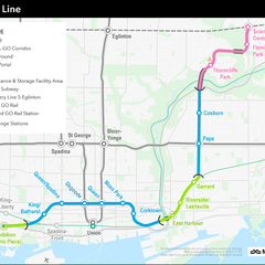
Metrolinx is hosting four public open houses to introduce the Ontario Line later this month. Fifteen potential stations are proposed between Ontario Place and Ontario Science Centre, with links to GO Transit, the Eglinton Crosstown LRT, and TTC Lines 1 and 2. The objective of the information sessions will be to provide the public with an overview of the project, the process, and information on future engagement opportunities.

The information sessions will be hosted in the last two weeks of January. The same information will be available at each event. Details of the sessions are below, and included in the flyer.
hYEEIlu2q7sIXoszELLOf0kKUYhY829UfIxQTRIt3YyFATI8styP_uITdb0M1uBwS1RqKdBdmLFWhVsGTkGP38vUMLlw6Xbn2XE_O4meMK2ogVA3kMKf-NQ=s0-d-e1-ft

Public Open Houses
Date: Thursday, January 23rd
Time: 6:30 p.m. – 8:30 p.m.
Location: Ontario Science Centre
770 Don Mills Rd, North York, ON M3C 1T3


Date: Monday, January 27th
Time: 6:30 p.m. – 8:30 p.m.
Location: Ryerson University, Tecumseh Auditorium
55 Gould St, Toronto, ON M5B 1E9


Date: Tuesday, January 28th
Time: 6:30 p.m. – 8:30 p.m.
Location: Metropolitan Community Church (Leslieville)
115 Simpson Ave, Toronto, ON M4K 1A1

Date: Wednesday, January 29th
Time: 6:30 p.m. – 8:30 p.m.
Location: Exhibition Place, Beanfield Centre, Room 201 ABC
105 Princes' Blvd, Toronto, ON M6K 3C3
 
Actually, an underground station at Eglinton is preferable for better connection to the Crosstown.

For Thorncliffe, I am thinking whether it would be a good idea to run the elevated line through the park between the community and the Don River?

From Pape, continue north-east, bridge over DVP, Don, and the Bala sub track. Then continue parallel to the rail track but north of it, to the elevated station south-east of Thorncliffe Park Drive. Continue elevated, next station being at Overlea Blvd just west of West Don. Then cross over West Don and the trail, and switch from elevated to underground before reaching Don Mills. And then, continue underground to the Eglinton intersection.

Thus, Flemmington would have an underground line. Throncliffe would have an elevated line in the south-east, and two stations serving the community (although none in the centre).
 
So stupid.

That said, i want Metrolinx to use this as an opportunity to show how elevated can enhance the public realm. Integrate artwork and lighting onto the elevated structures. Don’t make it boring and grey

Or make it boring and grey, but go ultra heavy on the vegetation and landscaping. Overlea has a very attractive treed median, may even be heritage. So if any future elevated line along there could be lined on both sides with pines that'd be very nice. Green in both summer and winter. Not sure if enough room though.
 
So stupid.

That said, i want Metrolinx to use this as an opportunity to show how elevated can enhance the public realm. Integrate artwork and lighting onto the elevated structures. Don’t make it boring and grey
Getting it done right takes a lot of time and careful planning, which runs contrary to the push to have this project rushed through the planning and design phases with minimal consultation.
 
I do think the station at Eglinton should be underground to avoid the disaster of a transfer that would result from an elevated station, but otherwise, elevated is the way to go through this area. If the province won't pay for landscaping to make it not hideous, maybe the city could at least do that since they aren't paying for the capital costs of the line itself (so far anyway)
 
I don't mind new surface transit going down existing rights-of-way.
The thing I'm worried about (as a self interested Riverside dweller) is how they will fit these new tracks into the existing rail corridor.
If they go up, it'll have to be way up to make room for Go electrification. But that wouldn't be so bad. I assume it would look something like the UPX spur at Pearson Airport. Or the Canada line in Vancouver.
The other option would be widening the corridor. Is that on the table?
If so, then they will be taking up a lot of park land, many houses and historic buildings. (eg. Is my beloved Bonjour Brioche toast? )
 
Yeah, the impact on GO expansion seems like a serious issue with the Riverside portion of the project. Not that Metrolinx will ever tell us, but it would be good to know the cost difference between running the Sherbourne-to-Pape portion of the OL up the RL alignment vs the OL alignment is. Because if we're going to cripple GO RER, it might be worth spending the extra money to use the RL alignment instead.
 
Leslieville residents in support of tunneling have started the Lakeshore East Community Advisory Committee.

A quick read of their site has me rolling my eyeballs to the back of my head. It's one thing to raise legitimate concerns and seek reasonable solutions to address them. But to be spreading a bunch of alarmist BS to their followers and in such an unprofessional manner, is not helpful to anyone and is a disservice to the entire community.

KNOW THE ISSUES
• No more subways: Unlike the City’s Relief Line, which was entirely underground, the Ontario Line will cross OVER the Don River and through the GO rail corridor on a widened at-grade embankment or elevated structure. That means two above-ground tracks from East Harbour to Gerrard (that’s ON TOP of the 4 GO tracks resulting from RER). It seems Mr. Ford’s had a change of heart since his brother was Toronto's Mayor and only “Subways! Subways! Subways!” would do.

• Questionably placed “Leslieville” station: The Queen/Degrassi station was widely rejected years ago by planners and residents alike. This is just a small example of the significant amount of time and money already expended on planning, feasibility studies, environmental assessments, design and community consultation on the City's relief line, which is now a colossal waste.

• Mitigation? What Mitigation? Yes, the technology used on the track will be lighter weight, therefore less noisy than diesel trains. BUT the IBC states "elevated guideways expose the trains to the open air, increasing potential for additional noise and vibration impacts for residents... due to frequent train passage.” If history repeats itself, we're in for trouble: some stretches of the GO corridor have no planned noise or vibration mitigation as part of the RER project. Doesn’t that make you wonder how effective mitigation on this project will truly be?

• Look Up, WAAAAYYYYY UP! If the Ontario Line does in fact become an elevated structure, it will need to be some 30+ feet in the sky to allow space for the elevated embankment, overhead catenary required to electrify the GO trains, and clearance of double-decker GO trains. It’s going to be awfully chilly up there in the middle of winter!


They then go on to post a Google Map link to this cherry-picked industrial section of the Skytrain as somehow representative of what Leslieville will look like.
WHAT ELEVATED TRACKS NEAR YOUR HOME COULD LOOK LIKE

2.jpg
 

Back
Top