Nobody denies that there is a market for the western relief line. That market is just much smaller than what exists in the east, with the eastern Relief Line moving nearly twice as many people as the west.

Ok, fair enough, but let's compare the DRL Phase 1 (Pape to Osgoode = 7 kms) to Eglitnon-Crosstown Phase 1 (Mt Dennis to Kennedy = 19 kms). The scope of the latter is far greater than the former; including the massive 11 kms that will be tunneled. If the same tunneled kilometre formula was applied to the DRL Phase 1 (11 kms), we easily could have a subway stretching all the way from Danforth/Pape to Queen/Dufferin, at which point we'd have the option of either going up the rail corridor or continuing westward using Roncesvalles/Parkside as right-of-way in a future phase.

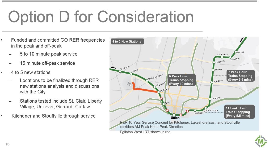
How much more can this possibly add to the costs and given the potential to alleviate chokepoints such as around Spadina, Bathurst and Liberty Village (Roncy/Queensway/King/Queen is also a chokepoint, but I digress)? This needs to be addressed. I don't think it's in Toronto's best interest to spend the next 15 years building something that will be quickly overwhelmed due to it's short length and the calls for expansion will be swift and immediate.
 
Don't forget that SmartTrack/RER or whatever could relieve some "chokepoints" from the west, north, and east. Fingers crossed.

r5aDwD7.png


optionc.jpg

optiond.jpg


These could happen before the Relief Line, but still subject to change.
 
The most shortsighted bit about the DRL is not extending Phase 1 to Spadina/Bathurst to relieve the streetcars, and prepare for future development in the area. I asked a planner why they decided to end Phase 1 in the Financial District, and his answer was "This was the area of study preferred by citizens in consultations".
Why would a bunch of people on the street have more input than city planners for something as basic as an area of study? And that's assuming these "consultations" even took place.

Sounds like another excuse by the city for not studying DRL-long in the first place, like they should be doing.
 
I wonder if the boring can continue under the active lines at Pape, Queen, and St. Patrick. I suppose it depends on geology and distance between tunnels.

If they can tunnel through, the line must be extended at least to the Don Valley (Millwood). Even if not, I imagine you would not want to dig up Greektown twice in a decade so building up to Millwood is mandatory. In the latter case, the Bloor to Millwood stretch would be cut-and-cover with a station at Cosburn. The bridge across the Don could be in the next stage, although it likely would cost $100-$200M and it may be needed if a train yard in Leaside is chosen.

If they can tunnel through at Yonge and University, then the tunnel should be extended West farther to a convenient extraction site - first we need to figure out where it's going. If they can't tunnel through, the tunneling would stop just east of Yonge and the Queen and St. Patrick station (and section in between) would be by cut-and-cover and the line would stop at St. PPatrick (well tail tracks a bit beyond)
 
How much life is left in the Leaside bridge ? I wonder if it's more feasible to build a double deck bridge instead of one just for the subway. It could act as a new 21st century icon for the city.
 
I wonder if the boring can continue under the active lines at Pape, Queen, and St. Patrick. I suppose it depends on geology and distance between tunnels.
I don't see why not; for Crossrail (Elizabeth line in London) they ran the TBM over existing platforms - and not very far over, while the tube was running. They monitored for any movement, and were prepared to shut down - but didn't have to.

However, I'd think that for all 3 stations, they'd be doing cut-and-cover, similar to the new Eglinton and Eglinton West stations on the Eglinton line.

They can also do what they did for some Crossrail stations, and build the station box first, and then just push the TBM through the station shell.

I'd guess though, that they'd simply do a single TBM run, from a launch site in the Pape station box itself, to a retrieval site either between Bond and Church on Queen Street East, or if they are brave, to the new Osgood station box.

If they can't tunnel through, the tunneling would stop just east of Yonge and the Queen and St. Patrick station (and section in between) would be by cut-and-cover and the line would stop at St. PPatrick (well tail tracks a bit beyond)
Not sure they'd go as far as St. Patrick. Will there be tail track? It might depend on how they link into the existing subway (and my guess is some kind of spur north of Gerrard station, along the GO tracks, to Greenwood Yard).

How did they tunnel the Sheppard line from Sheppard-Yonge station to edge of the Senlac station box? It is TBM? Did they run through Yonge, or did they relaunch it? Not sure which sequence they tunnelled it, or how many TBMs they used. Presumably the launched once from Don Mills, and recovered where it goes above ground near Leslie, and launched again from Leslie towards Yonge ...

How much life is left in the Leaside bridge ? I wonder if its more feasible to build a double deck bridge instead of one just for the subway. It could act as a new 21st century icon for the city.
Presumably rather a lot, given they recently finished that huge rehab on it. The first big rehab was when it was 40 years old, when they widened it, and then the rehab was about 35 years later. So at least another 25 years I'd think. Though I'd think it would only need another rehab. Did they do a full rehab in the 1960s, or just widen it?
 
They are the ones putting up money, they best sure be involved. How much money has Toronto put up...
they are putting up the money for the DRL? Is that what you are trying to say? Where did you dream that up,. The give $150M and you equate that with paying for the line!
 
they are putting up the money for the DRL? Is that what you are trying to say? Where did you dream that up,.
It was previously announced in one of the budgets (2015?) and as one of the Metrolinx's Next Wave projects ... all of the others that have received funding to date, have been 100% by the province.

Dream big!

Whether or not the combined federal/provincial funding be 100% like the Eglinton, Sheppard East, and Finch West lines, or less ... it is certainly going to be very significant.
 
It would have been an interesting thought if the Leaside Bridge were to be double-decked, as well as adding cables to it to be cable-stayed in order to add the extra capacity (as well as being a suicide barrier similar to that of the Luminous Veil). A hybrid cable-stayed double-decked truss bridge would be an engineering marvel. It would be the second cable-stayed bridge completely within Ontario's boundaries after the Nipigon River Bridge and we would hope that it would be the first without major flaws within a few months since opening.
 
Last edited:
Wouldn't it be cheaper to simply build a new span - and wouldn't the optimal location be further east, or at least angled further east.

Though I wonder if instead of a high bridge, that it be deep and under the DVP. if it daylighted,, perhaps there's a way of building a station in the valley for recreational access, and interchange with the Richmond Hill GO line.
 
Based on the latests info, construction will not happen until 2025.

The EA/TPAP will not be completed until late 2017.

2 more meeting added

  • Date:Wednesday June 15, 2016
  • Who: City of Toronto and TTC
  • What: Relief Line Public Consultation
  • Where: Matty Eckler Community Centre, 953 Gerrard St East, Toronto, ON
  • When: 18:30 p.m to 20:30 p.m.
  • Notes: presentation begins at 19:00 p.m.
  • Website: Relief Line
  • Date:Monday, June 20, 2016
  • Who: City of Toronto and TTC
  • What: Relief Line Public Consultation
  • Where: Calvary Church, 746 Pape Avenue, Toronto, ON
  • When: 18:30 p.m to 20:30 p.m.
  • Notes: presentation begins at 19:00 p.m.
  • Website: Relief Line

Why has TPAP completion been pushed back a year?
 
Wouldn't it be cheaper to simply build a new span - and wouldn't the optimal location be further east, or at least angled further east.

Though I wonder if instead of a high bridge, that it be deep and under the DVP. if it daylighted,, perhaps there's a way of building a station in the valley for recreational access, and interchange with the Richmond Hill GO line.

I would be much simpler to build a new bridge. I am not sure where the new bridge would be placed though. I imagine it would be immediately east of the bridge at the south abutment, and since it has to go back to the Millwood alignment, it would likely be parallel to the current bridge.

That bridge is 440m long, which back in 1927 required 11 spans with the maximum span of 38m. Now, a girder bridge could easily be built with spans twice as big. As for cost, a 30m bridge by 450m length would cost about $100M. Add maybe 50% for the second transit deck and you get $150M. Turn it into a signature bridge and you could multiply it by maybe 4 (i.e. $500M - $750M). Although it looks quite high, access is quite good, no piers needed in water, and we are in a low seismic zone.

If you want to connect the Richmond Hill line to the DRL, I suggest a gondola. Tunnelling under the Don River likely make a station at Cosburn impossible (or too costly).
 
These are the logical leaps that planning supporters make. At King St there are literally only two buildings separating a Yonge St address and Bay St address.
There's no existing/planned rapid transit near Yonge like there is two blocks from King (RER). Plus Jarvis is a lot farther from the heart of the financial district than Queen St is - almost double the distance from King and Bay (700 m vs 380 m). The whole Jarvis thing is a red herring.

What exactly is a planning supporter? Are we talking about sports teams now? Maybe we should debate the issues on their own merits instead of trying to assign everybody to some sort of faction.

Another huge stretch of logic. Did you know Bloor St is the same distance from College as Queen is? How many people make a 2km detour via Bloor and two extra transfers if they're going from Pape to University (4km)? You'd be adding 50% more distance and two extra transfers. Bloor would still be better because it has more stations that are easier to access (see below). King and Dufferin to Bay is 4km. A detour to Queen adds 20% and 2 transfers. Ain't nobody got time for that.

Queen is a jack of all trades, master of none. That's why it's projected to have lower ridership at ALL times of the day. The needs of the many outweigh the needs of the few. "Wider" service area that costs more and used by far fewer people is favoured only in Toronto.

The ironic thing is Tory and Kesmat's henchmen were out saying this subway would be drilled into rock which means stations on Queen will be much MUCH deeper than on King. It makes the hysteria over having to dig under PATH at King moot. I thought people here hated deep cavernous stations because they cost so much right? Deep stations make access a pain in the ass right? Queen was chosen for one reason only and that's to keep it away from Tory's crown jewels.

Henchmen? You must be confused. Rob Ford isn't mayor anymore.

I don't know why you're talking about detours. You mention College - if someone on College wants to go east or west they will be able to choose between going north to the Bloor subway or south to the Queen subway. It's a long walk, but doable. People will take whatever route makes sense, no detours required.

Look, if there were any possibility of two new east-west subways through the downtown area (and I have no doubt that they'd be successful), I might agree with you. But that's not going to happen in any of our lifetimes. This new line is indeed a jack of all trades, because that's exactly what it has to be.

With RER/Smarttrack stations at Liberty Village and Unilever, a King subway would duplicate much of the market for RER, which will have subway-like service where the lines converge downtown. Queen avoids that duplication along with expanding the rapid transit network to more of downtown and making rapid transit walkable to most of the core, including the financial district. College and the employment cluster in that area will still be a bit of a stretch to either subway line, but less so than if the new line goes along King.
 

Back
Top