..

(3) after crossing the Bala Sub below grade, emerges out of a portal north of Bond Ave for a massive 2 kilometre stretch of skybridge, including a station at York Mills Rd. Remains elevated over the 401 on its own separate bridge before descending into a portal by Parkways Forest Dr for the final stretch to the existing Don Mills Stn.

Thoughts or suggestions would be appreciated.
I think you are trying to avoid tunneling under the 401. But given Don Mills is on an incline from York Mills north to 401, would it be better to use that location for the portal ?
 
  1. I am not sure I like the jog onto Carlaw for a short stretch. It adds an extra curve (lowers speed, adds to cost, adds to ongoing maintenance).
  2. think 2 stations (at Mortimer and Torrens) are excessive. I would put it at Cosburn (actually maybe Gowan to just north of Cosburn, with entrances at each end). Maybe if it encourages them to built this cut-and-cover, I might let it go.
  3. Like your bridge to the south of the current Millwood bridge. That looks like about a 500m long bridge, somewhat high up, so assume a cost of $75M.
  4. I might just put it directly above the wide median on Overlea Blvd - from Millwood to the Overlea Bridge, but your route with cut-and-cover is also good.
  5. I Considered staying south of Overlea, elevated over Don Mills, and then curve north before Sunny Glenway with a station close to where you show yours.
  6. Agree that it has to go under Eglinton - even under the Eglinton LRT line so this will be somewhat deep.
  7. I would like to go elevated through Lawrence and the Donways, but it may be hard to ascend fast enough (from Eglinton) to do it before the CPR rail line, and there is not enough space between CPR and Donway.
  8. Agree with your routing north of the Richmond Hill GO (Bala Sub).
  9. Agree that it should cross Sheppard at 90 degrees, and not tie in to the Sheppard Line. To tie in to Sheppard, it would likely have to go underground with TBM at Graydon Hall and then follow under 401/404 up to Sheppard. Costly, extra curves, and its not what Sheppard needs.
 
When the first Yonge extension between Eglinton and York Mills was being designed, they wanted to out into the open and bridge over the Don River near York Mills. However, NIMBYs raised an uproar that such a bridge would lower their property values (ignoring the 401 bridges nearby, of course, in the process). So they went the tunneling method instead. See link.

Could this "excuse" happen here with the DRL?

ttc-york-mills-subway-model-1969.jpg


Model of an early proposal for York Mills station. As you can see, the subway would emerge from the side of the valley, cross York Mills and the Don River over a bridge, before diving back underground by Highway 401. York Mills station would have resembled Old Mill. Residents at the nearby Armour Heights neighbourhood objected, saying the "noise pollution" would adversely affect property values, even with Highway 401 already in place. This image is courtesy the Toronto Archives.
 
Totally irrelevant, but the Hoggs hollow bridge has 12 spans and more slender piers than shown. I don't know the year of that model, but either it was done before the 1964 highway 401 bridge was built, or they wanted to deliberately make the 401 bridge look more bulky compared to the proposed new subway bridge.

Hogs%20Hallow%20Bridge%20-%20Valley.jpg
 
To put this into an illustration for the forumers, I present this:


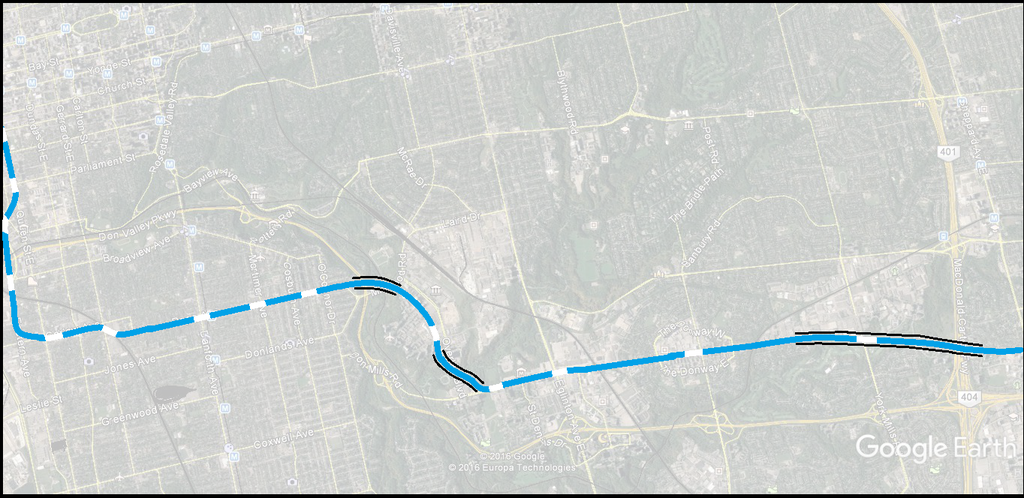
Elevation (skybridge) would exist in the following points:

(1): jetting out of Minton Place north of Pape Ave into the Don Valley but at a lower height than the Millwood Bridge to permit crossing underneath and reentering a tunnel between Milepost and Overlea Blvd (the pathway opposite St Edith Stein Catholic Church). This would allow for the Thorncliffe Park Stn to be located in the back lot of the East York Town Centre with the main entrance affronting Thorncliffe East and Overlea.

(2) jetting out of a second portal from the parking lot of the ITechnica Inc building, the subway crosses on a bridge underneath the Overlea bridge, past Valley Park Middle School then reemerges into a tunnel by the hydro corridor for the next station, Flemingdon Park, at Don Mills and Gateway Blvd (north leg).

(3) after crossing the Bala Sub below grade, emerges out of a portal north of Bond Ave for a massive 2 kilometre stretch of skybridge, including a station at York Mills Rd. Remains elevated over the 401 on its own separate bridge before descending into a portal by Parkways Forest Dr for the final stretch to the existing Don Mills Stn.

Thoughts or suggestions would be appreciated.
I do like this this alot, but I think it should above ground entirely from O' Connor to Sheppard ave, we need to save as much money as possible. Is there a way you could get a map like this done for an elevated Sheppard subway and Scarborough subway?
 
I do like this this alot, but I think it should above ground entirely from O' Connor to Sheppard ave, we need to save as much money as possible. Is there a way you could get a map like this done for an elevated Sheppard subway and Scarborough subway?

Of course I could. When I find some more spare time. I'm assuming you mean using the SRT alignment for Scarborough Subway Extension, correct?
 
Totally irrelevant, but the Hoggs hollow bridge has 12 spans and more slender piers than shown. I don't know the year of that model, but either it was done before the 1964 highway 401 bridge was built, or they wanted to deliberately make the 401 bridge look more bulky compared to the proposed new subway bridge.

Hogs%20Hallow%20Bridge%20-%20Valley.jpg

The bridge on the right is the original Hoggs Hollow bypass bridge, built in 1929. The one on the left was built as part of the widening of the 401 from 6 to 12 lanes in the 1960s. That accounts for the discrepancy in construction methodologies.

Dan
Toronto, Ont.
 
Remember that the province had the money to widen the 401 because it was for the car, but very, very little money for public transit, pedestrians, or bicycles.


This is neither fair, nor true although it is your strongly held opinion.

The highway was widened in an era when the economy was expanding at a rate of 6+%, families had two and three children, the median age was less than forty and the car was the future.

Public transit, bicycles and pedestrians were not foremost in transit planning.

The money was made available because it was seen as the inevitable way of the future. The situation has evolved and grinding our 2017 axe against the conventional wisdom of 1965 may give someone who didn't live through the entire experience the wrong impression.

While yes, highways are for cars - and trucks btw which deliver good stuff like food - the finding choice wasn't explicitly pro-car. It was simply the way that the thinking was. It was not an advocacy statement for cars and internal combustion engines.
 
Last edited:
yup. There are a bunch of failed government schemes from that era (Mirabel, Townsend, Pickering Airport / Seaton) that seemed reasonable at the time, but today look insane. Townsend was a governemtn planned town of 120,000 people to be built on the shores of Lake Erie from scratch with 20 hour work weeks for its residents. Today that seems nuts, but back in the 1970's, 6% growth seemed like it would go on forever and it didn't seem like it would be long until not only would it be possible, but it would be absolutely necessary. Nanticoke was built as its first primary employment centre, and the first couple hundred houses were built, then it died in the 1980's as growth slowed and manufacturing began to debase to international markets.
 
This is neither fair, nor true although it is your strongly held opinion.

The highway was widened in an era when the economy was expanding at a rate of 6+%, families had two and three children, the median age was less than forty and the car was the future.

Public transit, bicycles and pedestrians were not foremost in transit planning.

The money was made available because it was seen as the inevitable way of the future. The situation has evolved and grinding our 2017 axe against the conventional wisdom of 1965 may give someone who didn't live through the entire experience the wrong impression.

While yes, highways are for cars - and trucks btw which deliver good stuff like food - the finding choice wasn't explicitly pro-car. It was simply the way that the thinking was. It was not an advocacy statement for cars and internal combustion engines.

but even in today's economy, when it is clear that we should be moving towards public transit development as opposed to cars, highways and highway upgrades get built with much less debate even though they cost way more to construct that public transit. transit projects take years to get approved and funded but no one even questions highway construction nearly as much
 
yup. There are a bunch of failed government schemes from that era (Mirabel, Townsend, Pickering Airport / Seaton) that seemed reasonable at the time, but today look insane.

Was it a common concern amongst planners in the day that the road systems would eventually reach a capacity cap? Admittedly, I haven't researched this thoroughly, but from the historical planning documentaries I've watched, it seems like the sentiment was that highways would be adequate for the foreseeable future, and if those highways ever got full we'd just build more highways to "fix" congestion. Highways were "the future". Of course, in reality, it was hardly three decades after the introduction of the first superhighways before we were grappling with the very real limitations of our road system.

Of course, hindsight is 20/20. Who knows what 2017 planning policies we'll look back on with bewilderment in 2047.
You'll find this of interest:
The Fundamental Law of Road Congestion: Evidence from US cities
www.nber.org/papers/w15376
 

Back
Top