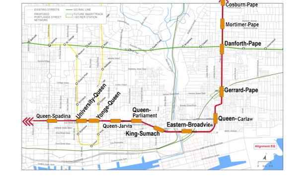
does anyone have the final proposed map?

This is the one from the website, still includes additional alignments, but it's the last thing I saw.

Map%20board_low%20res.jpg
 
Council is yet to approve the final alignment. At the July 2016 Council Meeting, Staff were requested to review the section between the GO corridor and Queen Street East before starting the formal EA/TPAP process.

11. “City Council approve the Pape-Eastern-Queen alignment for the Relief Line, subject to the determination of a specific alignment in Part 11b below, and authorize the Chief Planner and Executive Director, City Planning and the Chief Executive Officer, Toronto Transit Commission to..."

"b. undertake an additional assessment of an alignment west of Pape Avenue, starting immediately north of the GO tracks on Pape Avenue to south of Queen Street, with a station box at Queen Street and Carlaw Avenue"​
 
They could create circular tunnel stations at Queen & Pape and at Gerrard & Pape, similar to the St. Patrick and Queens Park stations.

subway-5103-05.jpg


20140129-Tunnel-QP.jpg
 
I thought the alignment was settled. The only question was whether it:
  • goes down Pape to Eastern, with stations at Pape/Gerrard and Pape/Queen, or
  • goes Pape to Gerrard, then jogs over to Carlaw and then to Eastern, with stations at Pape/Gerrard and Carlaw/Queen.
It seems like a lot of effort, just to move the station 100m west.

downtown-relief-line.jpg
 
Last edited:
They could create circular tunnel stations at Queen & Pape and at Gerrard & Pape, similar to the St. Patrick and Queens Park stations.

It was mentioned those stations would have to be mined like St Patrick and Queens Park, so I would think they would end up circular.
 
With the Unilever/East Harbour announcements, I take it there are no more debate over Queen alignment instead of Eastern?
 
The reverse is also true. Queen is a 5 minute walk from Eastern.

Unlike Eastern though, Queen won't be the site of 11.5 million sqft of office space and 50,000 workers.


Also queen has 501/502/503 and there is nothing on Eastern. Not even a bus.

Lastly there is the GO RER/Smart track station on Broadview/Eastern(Unilever site) The potential hub is very useful given that this area would be a major hub of employment.
 
Also queen has 501/502/503 and there is nothing on Eastern. Not even a bus.
I think that is probably a point against the Eastern alignment.

But the Queen-Pape Station will intercept the Queen streetcars, so there is no need to do that again at Queen and Broadview.

But yes, the potential hub there is another really strong point in favor of Eastern alignment.
 
I thought the alignment was settled. The only question was whether it:
  • goes down Pape to Eastern, with stations at Pape/Gerrard and Pape/Queen, or
  • goes Pape to Gerrard, then jogs over to Carlaw and then to Eastern, with stations at Pape/Gerrard and Carlaw/Queen.
It seems like a lot of effort, just to move the station 100m west.

downtown-relief-line.jpg

That map needs to be fixed:


If we were approaching building the DRL with the same level of care we applied to central Eglinton-Crosstown it would more resemble this.
 
The reverse is also true. Queen is a 5 minute walk from Eastern.

Unlike Eastern though, Queen won't be the site of 11.5 million sqft of office space and 50,000 workers.

There's already a ScamTrack station planned for there so it's unnecessary duplication. Did you know King Street near Ontario and Spadina has several million sqft of office space under construction and more than 50,000 workers and counting?
 
There's already a ScamTrack station planned for there so it's unnecessary duplication. Did you know King Street near Ontario and Spadina has several million sqft of office space under construction and more than 50,000 workers and counting?
We are talking about Queen vs Eastern, not Queen vs King.
 

Back
Top