M II A II R II K
Senior Member
They are yet to make it up since it's not known what would be needed at the time, especially to see how GO RER works out which could render some route picks redundant.
Was mentioned during one of the townhalls. I'll look for it.Mind linking to where Metrolinx confirming that a future extension is aimed to get to Roncesvalles? First time I hear of it.
@Rainforest great points. And to add, Metrolinx already said the line is going to Roncesvalles for OL West so how exactly do you think it will be easy to make a sharp turn up Dufferin to Queen? and the stop that will have to be at dufferin/queen on the way to Dundas West and (eventually) Mount Dennis? Come on folks.
It would be a nice addition for those traveling to the Hospital.Seems inevitable. But Roncesvalles and Queen or Roncesvalles and Dundas (near Dundas West station).")
wouldn’t it make sense to travel alng the rail corridor and have the station at Sunnyside and on to the Humber LoopSeems inevitable. But Roncesvalles and Queen or Roncesvalles and Dundas (near Dundas West station).
wouldn’t it make sense to travel alng the rail corridor and have the station at Sunnyside and on to the Humber Loop
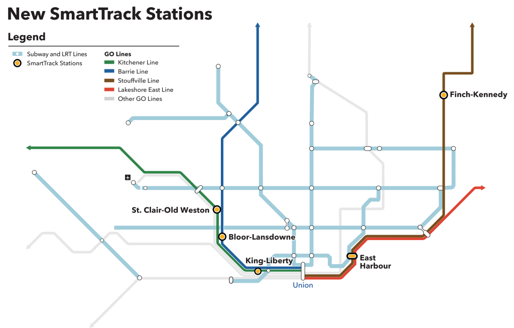
Huh? The corridor at Roncesvalles only carries the Lakeshore West line.There are three GO train lines along that corridor. (MI) Milton, (KT) Kitchener, and (BR) Barrie Lines. The Kitchener Line is getting three new stations at Mt. Dennis (connects with Line 5), St. Clair-Old Weston (512 streetcar) & King-Liberty (504 streetcar), and the Barrie Line is getting two stations at Caledonia (Line 5) and Bloor-Lansdowne (Line 2).
From link.
That rail corridor will be getting very busy.
Oh, you mean the Sunnyside sandbar.Huh? The corridor at Roncesvalles only carries the Lakeshore West line.

They only mentioned that with the inclusion of tail tracks they "protect for the westward extension". they never said it was going to roncy or dundas west. just that a westward extension is possibleWas mentioned during one of the townhalls. I'll look for it.
There was once a station in that area. I wonder if the OL ever makes it to Roncesvalles if there could be a possibility of rebuilding the station of the GO Train and make it another inter model hub with connections to the subway, streetcar and GO train. Looking at the area it seems with a little effort you could squeeze some platforms on the outer local tracks while express trains by-pass to Exhibition.Oh, you mean the Sunnyside sandbar.
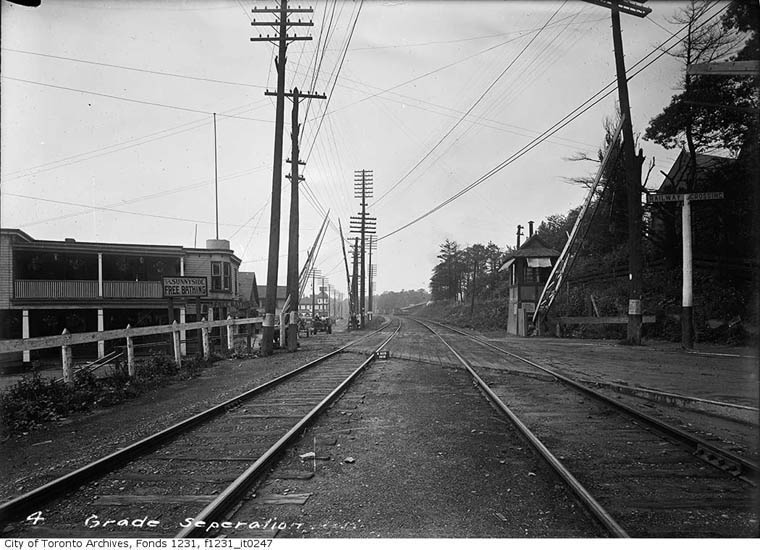
Before 1910, that railway corridor was a narrow railway at the foot of High Park.
Lakeshore at Sunnyside, 1910. From link.
Used to be no Lake Shore Blvd. east of Sunnyside, just a railway.
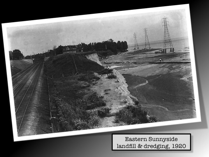
They had to dump landfill to create more space for more tracks, the roads, and Sunnyside beach.
From link.
The land is not perfect for construction of anything except at a great cost, since it was originally just a narrow sandbar.
I could have sworn they mentioned Roncy. I guess that's the official word then.They only mentioned that with the inclusion of tail tracks they "protect for the westward extension". they never said it was going to roncy or dundas west. just that a westward extension is possible
MX have previously said they have future-proofed the line for a number of options, including running up Dufferin, which explains the study bounds. IMO it makes the most sense, as there isn't an obvious way to fix Dufferin in this area other than a subway, plus Humber Bay Shores is getting a GO Station already. That said, I think any decision is going to involve waiting to see what ridership numbers are from Park Lawn station, and if that station is sufficient for the traffic from that area into downtown. We're a long way from any Western extension, as unlike the northern extension, nothing was being seriously studied during RL/OL development.(as I noted a while ago in the Ontario Line west thread), the original Ontario Line study area went west to Dufferin, but then shot up Dufferin to Melbourne Avenue (about half-way between King W and Queen W).
I'd assume then, that turning north onto Dufferin is a serious consideration. Whether that be to the Kitchener Line, Bloor, or further north I don't know. Though it does seem (from the most recent regional plan update) that the eventual target is Kipling station (before heading to Pearson).
I can't think of any north-south street in that area that needs higher-order transit more than Dufferin. Running it up to Dupont, then west along Dupont and Dundas to Kipling might be a very useful line. Though could head up Dundas from Dufferin as well, interchanging Line 2 at Dundas West station.
Though doing similar up Roncesvalles world work too.
So many choices.
View attachment 446471
I think too many people outside this forum consider Dufferin not far west enough. I would do this but city will want Dundas West station, and I don't blame them.(as I noted a while ago in the Ontario Line west thread), the original Ontario Line study area went west to Dufferin, but then shot up Dufferin to Melbourne Avenue (about half-way between King W and Queen W).
I'd assume then, that turning north onto Dufferin is a serious consideration. Whether that be to the Kitchener Line, Bloor, or further north I don't know. Though it does seem (from the most recent regional plan update) that the eventual target is Kipling station (before heading to Pearson).
I can't think of any north-south street in that area that needs higher-order transit more than Dufferin. Running it up to Dupont, then west along Dupont and Dundas to Kipling might be a very useful line. Though could head up Dundas from Dufferin as well, interchanging Line 2 at Dundas West station.
Though doing similar up Roncesvalles world work too.
So many choices.
View attachment 446471
A ROW expansion to long branch was due about two decades ago and would have rapidly quickened development in south Etobicoke. The thing holding it back is the TTC's dedication to maintain four lanes of car traffic along all streets they place ROWS. This would mean massive construction along the whole strip which provoked horror from residents when they first did public meetings in the early 2000's. The second the TTC abandons this idea it opens up drastically better streetcar service along Lakeshore west (and basically every other streetcar line in the city).The area is already served by a GO line, so the OL also going through the area seems like overkill to me.
I'd much rather see southern Etobicoke served by an LRT line between Exhibition OL Station and Long Branch (roughly speaking) via the TTC Queensway ROW. It'll be very cost effective, and would provide area residents with a quick one-transfer ride to the downtown core.
If we design this thing right, the LRT would only have two traffic lights between Exhibition Station and the dense residential developments at Park Lawn (circled on @EnviroTO's map).
West of Park Lawn, the LRT would interact with more traffic lights, however I'm not as concerned about that given the relatively modest ridership we'd see in that area (I suppose we could elevate it if necessary, but that seems like overkill).
LRT capacity could be an issue though. Such a convenient connection from Park Lawn to the Downtown core would induce a lot of Downtown-bound demand from this already very dense area. We'd likely have to figure out how to run the LRV's in two car sets, without impeding the operations of the TTC legacy streetcar network.
As for the Ontario Line, it absolutely needs to travel up Dufferin. It's one of our busiest, most unreliable and slowest bus routes in the city. The Ontario Line is pretty much the one and only opportunity we have to fix Dufferin Street transit.