Developer: LIUNA
  
Address: 595 Front St W, Toronto, Canada
Category: Residential (Hotel, Market-Rate Rental, Condo), Commercial (Retail), Institutional (Community Centre), Transit, Public Space / Park
Status: Pre-ConstructionCompletion: TBD
Height: 786 ft / 239.43 mStoreys: 72 storeys
Project Forum 1K posts
Real Estate Forum
Follow 30 followingUpload 183 photos
Official WebsiteReport Error


if they're going to raise the park up two levels above the rail corridor for parking, then there should be north-south road incorporated under the park since traffic is so bad in city place. I can't tell if that is what they envision.

However, I think it is best to not elevate the park any higher than necessary above the corridor.

You'd be introducing yet another level of complexity to a project that is already complex - not sure if that's wise. In any case, there should be a more gradual grading from south to north - as proposed, it's basically proposing to replace the ditch with a berm.

Again from the Architectural Plans:

upload_2017-5-24_21-14-15.png


AoD
 

Attachments

  • upload_2017-5-24_21-14-15.png
    upload_2017-5-24_21-14-15.png
    687 KB · Views: 1,001
Riddle me this:

Why would CN and TTR sell air rights if they had clear title to them? I proffer a great possibility that what has been sold, if anything, are *options* on those air-rights if it were ever determined that CN and TTR owned them in the first place. Outside of the Esplanade Corridor, railway companies did own land, some of it granted to them by the City. But on the Esplanade itself, railways were granted *concessions* (effectively leases).

Before anyone gets too excited either pro or con re Orca, there's the tiny detail of who actually owns the land, let alone the air-rights, to be clarified later in the year.

But getting back to the riddle: Why the heck would two of the most aggressive land developers in the nation (CN and CP) sell "air-rights" to some jump-up wannabe from the sticks?

Getting back to the Brooklyn Bridge...
 
The parking needs to be reduced to one level and the sloping of the edges made more gradual.

Like what's been said- they've taken a ditch and replaced it with a berm, which is not really much better from a connectivity point of view.

The space will almost be an island to itself when it needs to be a space that allows ease of movement (no huge ramps or lengthy detours) from all angles.
 
You'd be introducing yet another level of complexity to a project that is already complex - not sure if that's wise. In any case, there should be a more gradual grading from south to north - as proposed, it's basically proposing to replace the ditch with a berm.

Again from the Architectural Plans:

AoD
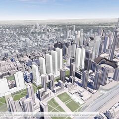
I've got to say that rendering, due to vertical relief, is vastly more appealing to the eye than anything the City has produced so far for their concept of the Rail Deck Park. If and when the City builds their deck, they should also consider vertical separation in spots, it is far more 'natural' and appealing, and also lends itself to engineering utility of what's adjacent, laterally or vertically. Good chance those Orca drawings and plans will be sold-off at the bankruptcy sale shortly after a court decision later in the year. City should buy them...
 
I've got to say that rendering, due to vertical relief, is vastly more appealing to the eye than anything the City has produced so far for their concept of the Rail Deck Park. If and when the City builds their deck, they should also consider vertical separation in spots, it is far more 'natural' and appealing, and also lends itself to engineering utility of what's adjacent, laterally or vertically. Good chance those Orca drawings and plans will be sold-off at the bankruptcy sale shortly after a court decision later in the year. City should buy them...

There is nothing remotely "natural" about a linear form as proposed - and pretending to be natural for a site like this is fundamentally questionable to start in any case.

AoD
 
There is nothing remotely "natural" about a linear form as proposed - and pretending to be natural for a site like this is fundamentally questionable to start in any case.

AoD
Are you talking the City's or ORCA's rendition? Because the City's renditions look even less natural. They look like green parking lots. In the event, the point is moot.

I've been on New York's Riverside Park many times before finding out later the West Side Line runs underneath there. And parks in London too over rail lines, not knowing it. Even Toronto has spots over the Yonge Subway where you'd never know tracks run underneath.
 
Are you talking the City's or ORCA's rendition? Because the City's renditions look even less natural. They look like a green parking lots. In the event, the point is moot.

I've been on New York's Riverside Park many times before finding out later the West Side Line runs underneath there. And parks in London too over rail lines, not knowing it. Even Toronto has spots over the Yonge Subway where you'd never know tracks run underneath.

What I am saying is that I'd rather a park not pretending to be natural when it isn't.

AoD
 
What I am saying is that I'd rather a park not pretending to be natural when it isn't.

AoD
In all fairness, looking at the other pics, they look awful. I was referring to the "mid-block connection park" pasted in above. Of course, as renders tend to do, it conveniently ignores the the imposing structures to the left and right.
 
Last edited:
Are you talking the City's or ORCA's rendition? Because the City's renditions look even less natural. They look like green parking lots. In the event, the point is moot.

I've been on New York's Riverside Park many times before finding out later the West Side Line runs underneath there. And parks in London too over rail lines, not knowing it. Even Toronto has spots over the Yonge Subway where you'd never know tracks run underneath.

What I am saying is that I'd rather a park not pretending to be natural when it isn't.

AoD

In all fairness, looking at the other pics, they look awful. I was referring to the "mid-block connection park" pasted in above. Of course, as renders tend to do, it conveniently ignores the the imposing structures to the left and right.

I also see dead people all burnt, but that's another matter...

Shouldn't we save the reading the tealeaves/renders until its design actually starts? The prior renders are clearly conceptual, and are in no way indicative of the final design.
 
Shouldn't we save the reading the tealeaves/renders until its design actually starts? The prior renders are clearly conceptual, and are in no way indicative of the final design.

Detailed design of the park yes - but how the space is organized is driven by the use of the decking, which is more fundamental to the project.

AoD
 
Yeah I'm going to add to the chorus against the parking decks. That is completely ridiculous. It adds to much height compared to the grade at Cityplace, and I worry about salt eating away at the structure over time.

It needs to be integrated into a podium elsewhere, I agree, but finding space elsewhere, out of the rail corridor, would have been optimal.
 
With a half hour Google search, I can't find any reference in the public domain on legal issues since the Globe and Mail article last Fall:
[...]
The city’s chief planner, Jennifer Keesmaat, has previously dismissed the alternative plans, saying a win for the city in any OMB battle would be a “no-brainer.” Ms. Keesmaat also told The Globe last month that the city had no confirmation the developers had even purchased the air rights from the railways.

To address this claim, Mr. Griffis instructed his lawyers to send The Globe two short letters provided to city planners and dated Sept. 15. One is from a lawyer for Craft, the other from a lawyer for Canadian National Railway Co. and the Toronto Terminals Railway Co. Ltd., the company co-owned by CN and Canadian Pacific Railway Ltd. that controls the tracks around Union Station.

The letters say that Craft entered into a “binding and enforceable” agreement of purchase and sale in 2013 for “air space above the rail, south of Front Street West, between Bathurst Street and Blue Jays Way.”

The letters do not say if the deal has closed. The letters also do not say whether the deal is conditional on the land actually being zoned for development or for a certain density – a common clause in such deals. Mr. Griffis would not reveal any other details on Tuesday. Mr. Sweeny said the deal had not yet closed.

Local city councillor Joe Cressy, a booster of the city’s rail-deck park concept, said he and city staff had seen those letters but that they lack necessary details. The developers themselves, he said, told him when they met earlier this year that the deal was “conditional.” Regardless, he said, the city will still need to discuss terms with whoever actually holds the air rights as it proceeds with its plans to build the park.[...]
https://www.theglobeandmail.com/new...s-for-toronto-rail-deck-park/article32252388/

If anyone can find anything further on this aspect, please post. I'll continue dabbling at finding any. In all due respect, I think the City itself is in for a pleasant surprise on ownership of the land, and any subsequent air-rights that come with it. Not only does it appear the City owns most if not all of the original Esplanade Corridor (much more than the present street), but they might have a claim on some adjacent property too.

This is all a very curious situation.
 
What does ORCA stand for, anyway? The new thread title is meaningless - could we add, in brackets, "Rail Deck Park?"
 

Back
Top