You are using an out of date browser. It may not display this or other websites correctly.
You should upgrade or use an alternative browser.
You should upgrade or use an alternative browser.


sotoronto
New Member

Last edited:
dt_toronto_geek
Superstar
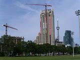
July 20th Update
This looks good in person, I like. Those banners don't do the building any favors, but of course they're only temporary.
It seems just like last summer that I photographed the breweries being demolished here.
Click on the thumbnail to enlarge, then click again on the image for full size.
This looks good in person, I like. Those banners don't do the building any favors, but of course they're only temporary.
It seems just like last summer that I photographed the breweries being demolished here.
Click on the thumbnail to enlarge, then click again on the image for full size.


Redroom Studios
Senior Member
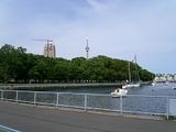
the photo sotoronto was linking to above... great view, shame about the cloudy day which we've been having way too many of.

Hypnotoad
Senior Member
^^ Great photo. It really illustrates how much room/land there is between Fleet Street and the Gardiner. It doesn't seem that large when I bike down there but I guess the construction gets distracts me.
Looking at this photo and remembering the area map (earlier pages), it seems odd that they put the point towers directly against Fleet Street. I'd rather the plan called for the towers directly against the Gardiner and have small, mid-rise structures stepping down to Fleet.
Looking at this photo and remembering the area map (earlier pages), it seems odd that they put the point towers directly against Fleet Street. I'd rather the plan called for the towers directly against the Gardiner and have small, mid-rise structures stepping down to Fleet.
dt_toronto_geek
Superstar
I just walked over the Bathurst Street bridge yesterday and didn't realize even from up there how much property is still available along side the Gardiner. That shot illustrates it very well.
Eastside
Active Member
It's going to be really interesting to see how the opening of Fort York Blvd. up through the Cityplace lands changes the feel of this area. On the one hand, it will open up the West Harbour City and surrounding towers to the core quite a bit, but I think it also may become a rush-hour nightmare with drivers using this as a shortcut to get to Lakeshore Blvd..
Allwork
New Member
Does anyone know if you can request to view your unit while under construction? I'd rater do this than sneek in after hours 
scrappyTO
Active Member
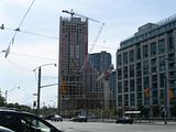
Tower crane came down late last week.
CityLover
New Member
Tower Crane came down....
What does that signify?? I honestly don't know...
Thanks...
What does that signify?? I honestly don't know...
Thanks...
Ramako
Moderator
What does that signify?? I honestly don't know...
Thanks...
It signifies that the crane is not there anymore. No more heavy lifting.
tgam
New Member
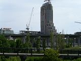
Took this one earlier this year:

maestro
Senior Member
Looking at this photo and remembering the area map (earlier pages), it seems odd that they put the point towers directly against Fleet Street. I'd rather the plan called for the towers directly against the Gardiner and have small, mid-rise structures stepping down to Fleet.
I imagine what's on the other side of the Gardiner had a whole lot to do with it.
urbandreamer
recession proof
1 August 2009 photo update


Gooner
Active Member
What are peoples thoughts of the value of this project? I figure the per sq ft is around $410. Is that a good price for this area etc.
Thanks....
Thanks....