News   GLOBAL  |  Apr 02, 2020
 11K     0 
News   GLOBAL  |  Apr 01, 2020
 43K     0 
News   GLOBAL  |  Apr 01, 2020
 6.7K     0 
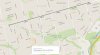
TTC will rename Eglinton West station to Cedarvale. "It helps promote the neighbourhood rather than an arterial road,” said Mihevc. The other two interchange stations will retain their original name.

http://www.thestar.com/news/gta/tra...ecome-cedarvale-station-on-crosstown-lrt.html

Forgive me if this has been discussed elsewhere. Why do interchange stations have separate names for the stops on the respective lines? For example, Eglinton West and Cedarvale. Does it not simplify things to just refer to both stops as being the same station? Montreal does this. A quick look at Washinton DC's map shows they also do this. Just seems easier.

Is Toronto's practice a legacy thing?

Toronto does use single names as well, where practical. Look at Kennedy and St. George.

The issue comes up, however, when you have an existing station on an existing line, and convert it into an interchange station. Bloor-Yonge and Sheppard-Yonge are both holdovers from the fact that the Yonge line was the first line through, and the station was named after the major crossing street - as is the convention. Calling a station "Bloor" doesn't really give any locational reference when the line runs primarily under Bloor St. - thus they appended the "Yonge" to the name.

I don't see any issue with continuing this convention with the Eglinton Line, but apparently Metrolinx does.

Dan
Toronto, Ont.
 
Forgive me if this has been discussed elsewhere. Why do interchange stations have separate names for the stops on the respective lines? For example, Eglinton West and Cedarvale. Does it not simplify things to just refer to both stops as being the same station? Montreal does this. A quick look at Washinton DC's map shows they also do this. Just seems easier.

Is Toronto's practice a legacy thing?

It's a legacy of inconsistency, yes. As in St George but not Bloor/Yonge.

There will always be key destinations that require learning and memory - What's the station for Sick Kids Hospital? Air Canada Center? L'arc de Triomphe or Buckingham Palace, for that matter? Hopefully wayfinding is intuitive and helpful, but it will never be 100%.

There is no perfect approach, and no approach is wrong. I like a "Use a main street where possible" as the primary rule. Bloor/Yonge works best because each street is central to wayfinding for people on that specific line. Falling back on a landmark or district (if we are not arbitrarily fudging its boundaries) is OK as the alternative. Naming after people is wrong.

I would have picked Strathearn over Cedarvale, it hints at district while being technically a cross street. In my world, Eglinton/Allen is "the place that was technically part of Forest Hill Village, that people bought houses in because they could say they lived in Forest Hill but the prices were much lower". I guess that's a bit long for a subway tile.... Cedarvale is good enough.

- Paul
 
I like Joe. I went to numerous eglinton LRT meeting and he was at the majority of them advocating for transit.
 
Remaining distance (excluding Humber and Lea):

Capture.JPG
 

Attachments

  • Capture.JPG
    Capture.JPG
    89.6 KB · Views: 700
I'm really annoyed at politicians taking the population for idiots. There's nothing confusing about "Eglinton West" or "Eglinton-Yonge". The arrogance...I swear...:mad:
 
Remaining distance (excluding Humber and Lea):

By eye, it looks like the tunnelling is at about the 50% completion point overall. And with four TBM's now running instead of two, we can hope for good progress going forward. I wonder if Tigermaster can handle all the happy dances.

- Paul
 
Quoting someone from facebook:


Re: Crosslinx & Eglinton Crosstown

I attended a business opportunities meeting hosted by Crosslinx earlier this week and there were some pretty great revelations not mentioned before. For those of you interested, here are some highlights:

-Not all stations will be cut/cover, some will be mined! (More on this below)
- Keele will be the first station built as a pilot and will commence construction March 2016
-construction for the others will commence Summer 2016
-stations will take ~3.5 years to build

They are dividing the line into 6 segments:

1) Mt Dennis, Keele, Kodak Lands, MSF and the portal/Blackcreek Guideway

2) Caledonia, Dufferin, Bathurst, Chaplin, Mt. Pleasant & Caledonia GO
-These will be cut/cover
-Crosslinx wants to get "creative with construction" in order to minimize community impacts and claims they will use cutting edge engineering never used before.

3) Interchange Stations @ Allen & Yonge

4)Oakwood, Avenue, Bayview & Laird
These will be Mined from the Sides instead of Cut & Cover! Very cool!

5) At-Grade Sections

6) Track Work, Catenary Polls, Signaling Etc and the system wide installation
 
Oakwood, Avenue and Bayview will be mined, yes. But it was my understanding that Mt Pleasant was the other one to be mined, not Laird.

Dan
Toronto, Ont.
 
Does anyone have a rough idea as to how large an opening we'll see on the surface for the mined stations? We know that Queens Park and St Patrick were done the same way, and I think it would be helpful to DRL supporters on the topic of alignment if we know to what degree the surface can be disturbed in locations downtown.
 
By eye, it looks like the tunnelling is at about the 50% completion point overall. And with four TBM's now running instead of two, we can hope for good progress going forward. I wonder if Tigermaster can handle all the happy dances.

- Paul

I still don't believe it. I'm pretty sure this is an elaborate prank you guys are pulling on me ;)
 

Back
Top