


DSCToronto
Superstar
Martin Goodman REPAVED from Cherry Beach to Unwin Bridge and open again. Blue line painted about 80% of way starting at Unwin Bridge. No green line, yet. VERY nice smooth ride!!!
Last edited:
|
|
|
Are these new? I do not think they are standard City issue and the City are certainly still putting in their famous post & ring ones.
In recognition of Louis March’s decades-long commitment to public safety, equity and youth development Shuter-Sumach Parkette was renamed to Louis March Park on July 20, 2025. The neighborhood around the park was where Louis did some of his most impactful work, supporting the most vulnerable communities in Toronto and his deep commitment to ending gun violence.I don't understand their logic sometimes for these bike posts. I figured they would focus on durability and use a consistent design but that doesn't seem the case in many regards. Like a park on Shuter, right near River, was rebuilt over the last year, they changed the name as well but I don't remember the new name atm.
They installed these...
View attachment 694301
They were installed a few years ago when the BIA completely redid the sidewalks along Bloor. They were flimsy from day one and look like they could easily be pulled from the ground today.Are these new? I do not think they are standard City issue and the City are certainly still putting in their famous post & ring ones.
Does anyone know why they planted some islands along Harbord, while others they paved over?Last stretch of Harbord from Grace to Ossington is done - took some images here: https://panoramax.openstreetmap.fr/...4/0.00/30;m19.57/43.6600013/-79.4175336;vd;bs
They planted some so Parks could park their trucks in them instead of on tree roots.Does anyone know why they planted some islands along Harbord, while others they paved over?
")
This is coming to Council today: SEE https://www.toronto.ca/legdocs/mmis/2025/te/bgrd/backgroundfile-259388.pdf
Lake Shore Boulevard East Trail Connections
The reconstructed Lake Shore Boulevard East, between the Don River Bridge and Carlaw Avenue, will have multi-use trails on both the north and south sides. At Carlaw Avenue, these trails will connect to the existing trails continuing east along Lake Shore Boulevard East, towards Woodbine Beach and beyond. At Don Roadway, they will connect to the new trail recently opened along Don Roadway, connecting south to Commissioners Street, west to Cherry Street, and back north to Lake Shore Boulevard East. These trails connections are shown in Attachment 1.The remaining multi-use trail gap along Lake Shore Boulevard East, between the Don River Bridge and Cherry Street, will remain closed following completion of this project. Waterfront Toronto has been directed to implement a communications/signage plan to advise people cycling that the trails do not continue beyond the west end of the bridge and how to navigate the broader area. New multi-use trails will be constructed west of the bridge as part of the Gardiner Section 5 and Lake Shore Boulevard East Reconfiguration project, expected to be completed in 2030. Staff are exploring opportunities to construct a temporary multi-use trail in 2026 to re-establish this connection in the interim and will report back to City Council with further details, as required. (My emphasis.)

 www.toronto.ca
Don't know for sure but maybe is it has to do with providing daylighting at intersections while keeping sight lines from being obscured where there will be turning traffic, and along with that not putting vegetation in the turning path of wide-radius vehicles. My gut says at Grace we see vegetation on the east side because no cars turn right from Harbord since Grace is one-way southbound, but on the west side it's filled in with concrete because it can provide somewhere for a Bike Share van to park while it services the docking stationDoes anyone know why they planted some islands along Harbord, while others they paved over?
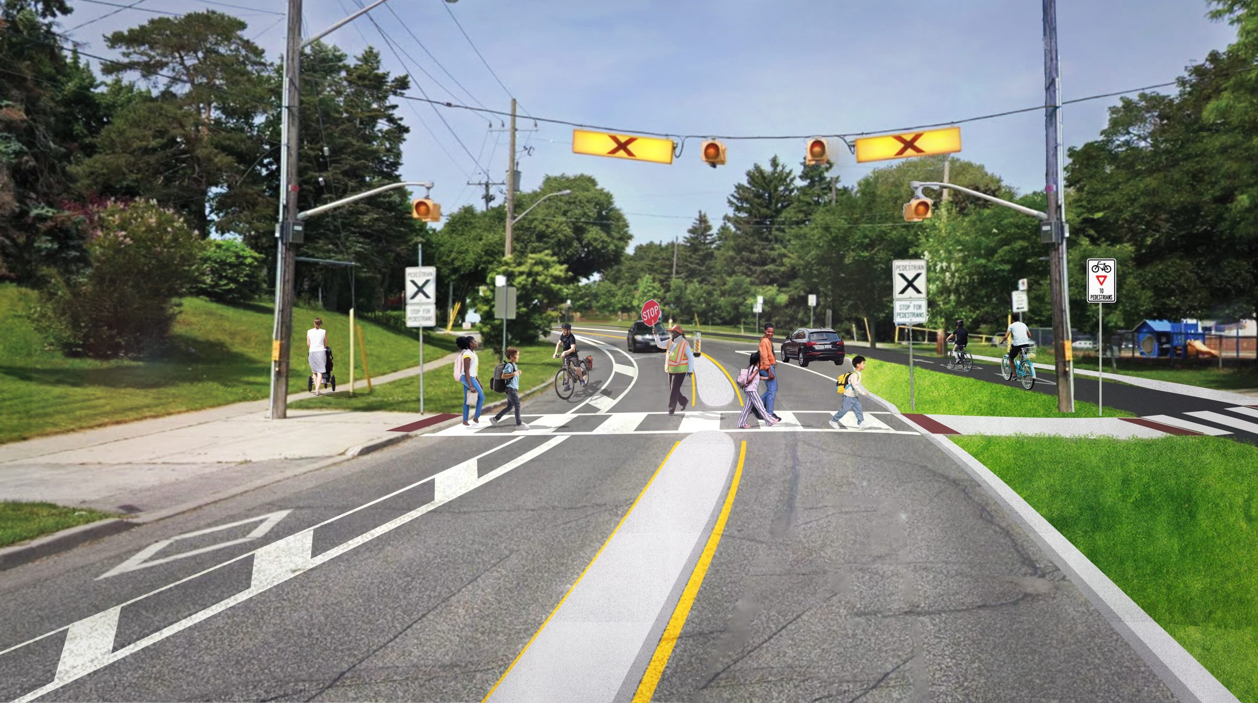
New consultation up for changes to Vaughan Road and Wychwood.
Vaughan Road and Wychwood Avenue Safety Improvements
The City of Toronto is inviting residents to learn more and provide feedback on road safety upgrades and opportunities to make changes to cycling, pedestrian, and motor vehicle operations on Vaughan Road, Wychwood Avenue, Arlington Avenue, Robina Avenue, Hursting Avenue and Maplewood Avenue...
Presentation Materials:
Survey Link:
https://ca.mar.medallia.com/?e=90001053&d=l&h=608E8EF1F36BB69&l=en ( closes Nov. 27th)
Drop-In Event:
View attachment 695194
@TwoWheelPoli and @AlbertC among others will have thoughts.
Too many panels to post here.
But I'll offer up this one:
View attachment 695195
And this one:
View attachment 695196
For the rest, follow the assorted links.
 www.toronto.ca
I also saw on the cycling public consultation page something regarding Brimorton, but unless my eyes deceive me, I'm not seeing that many improvements proposed. No public meeting or presentation slides are available, but there is a note to submit your comments by e-mail by Sunday, December 7. I sent this to Toronto East Cyclists to see what they can read from this.
Brimorton Drive Roadway Improvements
Public Consultation is now closed. View the Phase 2 Consultation Report. The City of Toronto is inviting residents to learn more and provide feedback on road safety upgrades on Brimorton Drive as part of Phase 2 consultation. Starting in 2026, road work is planned on parts of Brimorton Drive...
Working full out, I see! I assume there is now zero chance of paving until it warms up again next year. This really has been a totally mis-managed project.