It looks like Toronto owns the original land of the Island and Ports Toronto most of the fill.

I believe this is correct.

Here is a photo from 1937:

1727721818252.png

Source: https://www.billybishopairport.com/the-airport/history-of-the-airport/

To my understanding, what you see above would be the City owned portion of the airport lands, with everything that was 'filled' being Toronto Harbour Commission (later Ports Toronto)
 
The events in the U.S. this weekend should give pause in considering what can and should be constructed on lands that storms have caused fundamental change to, and therefore the cost to flood proof same to be included in the base infrastructure specification before anything is constructed and occupied.
Most of the damage in the USA is from the tidal surge. We've had some significant storms this summer that have caused some flooding, and the extreme lake levels a couple of times in the 2010s. Neither of these had much effect on either the airport, or ferry operations.

There's a huge difference between land adjacent to an ocean, and what is now a land-locked reservoir controlled by a dam.
 
Most of the damage in the USA is from the tidal surge. We've had some significant storms this summer that have caused some flooding, and the extreme lake levels a couple of times in the 2010s. Neither of these had much effect on either the airport\
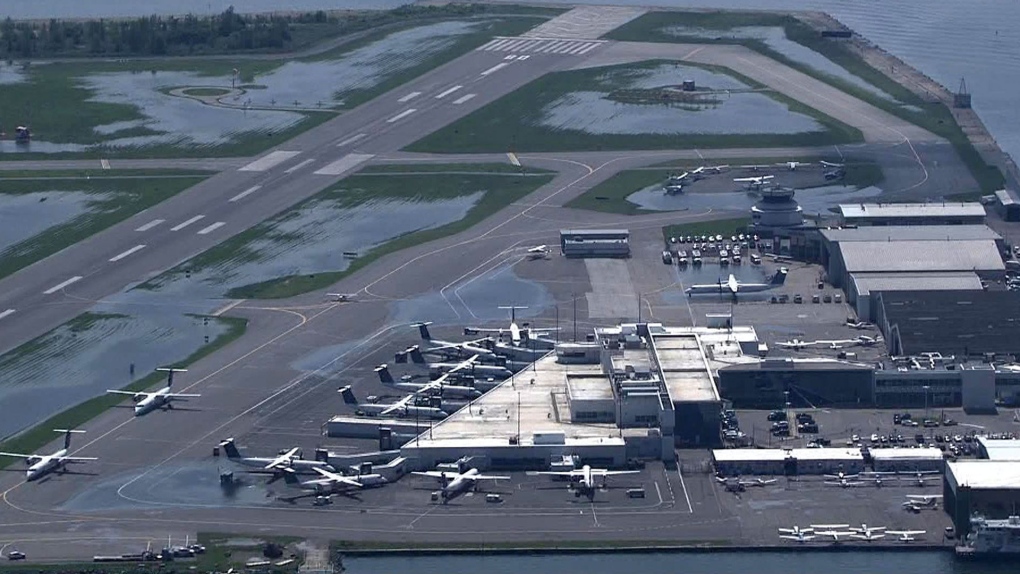
The storm this July did in fact close the airport, mainly a precautionary measure due to the risk of the pedestrian tunnel flooding. Though, the airport did suffer power outages as well.

There was on land flooding at the airport as well, however, it didn't have any material impact on the runways.

This can be seen from the following footage:


***

I'm happy enough to agree that the risk profile from 'surge' is different and lower than tidal areas on the U.S. Atlantic coast.

But I would add, it wouldn't take water levels much above those record highs of a few years ago to be quite disruptive.

This is the flood vulnerability of the Islands based on the 2017 Lake levels. Note that Billy Bishop is not in the blue (flood zone)

1727725305488.png


Source: https://spacing.ca/toronto/2017/07/12/mapping-flooding-toronto-islands/

Quick math suggests BB to be 15cm higher (for the most part) than the flood risk zones based on 2017 Lake Levels. (just under 1/2 a foot)
 
I mean going by that map, most of Billy Bishop is between 76.08 and 76.91 metres ASL, so between 15 and 100 centimetres of the flood level. That 15cm measure is also the "minimum" for the colour category which in itself has a variance of 37 centimetres, so the lower elevations of the airport are between 15 and around 50 centimetres higher than the record flood levels.

Lake Ontario is sitting at about 74.8 metres today, for comparison. So the airport can accommodate about 2 metres of water level rise before starting to experience issues.
 
Presumably, with Doug Ford in office, the City needs to be mindful of the limit it can drag its feet before QP starts legislating away ownership and so forth. After Therme, who can say what they wouldn’t do.
 
Presumably, with Doug Ford in office, the City needs to be mindful of the limit it can drag its feet before QP starts legislating away ownership and so forth. After Therme, who can say what they wouldn’t do.
Remember, Chow gave up the small piece of land that the Ontario government needed.

Hypothetically Ford could order Expropriation but would need to pay market value for that land. Could take a few years but you couldnt really stop it.
The feds under PP could probably do the same.
 

This runway extension is not even a sure thing. Without a for sure lease extension who would provide a 60 million loan on the offchance it might close in only 5 years at the time of completion? Things could progress really quickly here since they require a re-signed agreement by the end of January. If they dont get detailed design started soon afterwards theres some massive risks for them. Keep in mind 2-2.5 years is the estimated construction time

Be ready for some LOUD lobbying to the province here. A denial of the extension, is very close to being a closure of the airport
 
Remember, Chow gave up the small piece of land that the Ontario government needed.

Hypothetically Ford could order Expropriation but would need to pay market value for that land. Could take a few years but you couldnt really stop it.
The feds under PP could probably do the same.
Feds trump the province here, no?
 
Feds trump the province here, no?
So like I dont think its ever been the case where 2 entities want to expropriate the same property at the same time LOL.

But my guess would be that ford intervenes which backs PP away since its not really his fight.
 
They most certainly are, LOL

Shortening the runway to meet RESA requirements would eliminate use by Dash-8 aircraft which would shut down the commercial carrier that flies a large number of flights from said airport.

View attachment 599970

From: https://www.toronto.ca/legdocs/mmis/2024/ex/bgrd/backgroundfile-249034.pdf
That would presumably leave only the much smaller planes with significantly fewer passengers, and end Porter and Air Canada Express/Jazz operations there, and make the existing terminal and much of the other existing passenger-oriented facilities pointless.

Regarding the new U.S. Customs Preclearance facility, while maybe an improvement, I wouldn't count on it to necessarily "open up more routes to the United States from Billy Bishop". Airlines still using turboprops in U.S. have become increasingly rare in recent years.
 
But I would add, it wouldn't take water levels much above those record highs of a few years ago to be quite disruptive.

...

Quick math suggests BB to be 15cm higher (for the most part) than the flood risk zones based on 2017 Lake Levels. (just under 1/2 a foot)
They really can't get much higher, with the dam. And they could have mitigated the lake levels at any time by opening the flood gates - which was certainly happening the second (higher) time.

Though the lake level at this end of the lake is rising about 5 cm a century ... so maybe in the 2200s or so they'll have to raise the land level by 6 inches. :)
 

Back
Top