Best direction for the Green line at this point?

  • Go ahead with the current option of Eau Claire to Lynbrook and phase in extensions.

    Votes: 42 60.0%
  • Re-design the whole system

    Votes: 22 31.4%
  • Cancel it altogether

    Votes: 6 8.6%

  • Total voters
    70
Stoney Trail might/should be the last massive large investment in major road projects for the city. At least in the context of making roads bigger and faster.

Crowchild between the river and 24th is being looked at but what if we kept it as is and only made safety and aesthetic improvements? NW drivers are well served by the ctrain, north central drivers can be well served by the Green line? We would save a lot of money on projects that would only make a small difference. Heck, don't bother doing those deerfoot improvements either, lets get radical! Haha

The city is doing a 'Social Return on Investment Analysis' for the Foothills athletic park + McMahon area, I'd like to see a social return on invest analysis done on road versus transit investment.
Exactly. Upgrading that stretch of Crowchild according to the current plans is $2 Billion+, which is more or less the same cost as the Green Line's north segment. In my opinion that's an easy choice to make.
The reason we don't have much transit is because our transit is expensive.

But the reason that transit is expensive here is that it is planned with the fundamental assumption that drivers must not be inconvenienced. Tunnelling is expensive and wildly increases uncertainty and cost, but why are we tunnelling? The only things in the centre that the Green Line fundamentally can't cross at grade are the CP Rail and the river. Everything else is a choice. The Beltline portion of tunnelling was largely to avoid crossing Macleod at grade and inconveniencing drivers. Running downtown at grade could make east-west traffic a little slower, but not a lot. Instead of taking two lanes from 11th avenue and First street, we're spending a billion dollars. If the situation was reversed and the train was there already, would we spend a billion dollars to add two lanes to these roads? There should be the same answer to both questions.

North-south and east-west LRT lines cross at grade in downtown Portland (it's even one 1970s high-floor line and one current low-floor line like we have), so it should be possible to do that here as well, although our east-west corridor has higher train volumes, and eventually there will need to be a tunnel downtown somewhere.

There's a great saying in German, Organisation vor Elektronik vor Beton -- organization before electronics before concrete. That is, the first and cheapest changes involve optimizing your organization and operating; the second best is optimizing your signals and so on, and only once those have been exhausted should you build new infrastructure. We've taken the reverse tack here, very much at our cost.

It's not that the portion of the Green Line project that serves transit users is expensive and risky; it's the portion that serves drivers.
I don't agree with this, because tunneling objectively helps transit too. As @darwink mentioned a huge portion of the efficiency/time savings that justify the green line would come from the tunnel underneath downtown.

After riding on European metros with their dedicated underground ROWs, our downtown LRT is pitifully slow in comparison. I trust the experts on the green line planning committee to make the right call on cost versus transportation benefit, especially in a city like us with high projected long term growth.

The bigger reason that our transit is expensive is because for most of our existence our city has been planned almost exclusively around cars. This means transit needs to go further to serve less people. And on top of that, making transit competitive with cars is an incredibly difficult logistical and geometric task that can be greatly harmed by just a few mistakes. Expanding car access is comparatively much easier.

If you look at our city building history it seems like we have basically never thought of transit as a mode which should be competitive with cars, rather, we've just thought of it as a tool to provide a social service and relieve congestion on the road network. The way we have built out reflects that, and that makes it difficult and expensive to reverse that trend.
 
our downtown LRT is pitifully slow in comparison
Isn't this mostly to do with the numerous north/south crossings and the fact the trains have to stop at traffic lights?

There should on really be 5 track crossings (Macleod North and South, 4th and 5th St., 8th St., and 11th St. (but only if the underpass is multi-mode).

Maybe that doesn't speed up the train that much and what do you do with pedestrians? But its something.
 
Stoney Trail might/should be the last large investment in major road projects for the city (understanding the city only really paid for approach road improvements). At least in the context of making roads bigger and faster.

Crowchild between the river and 24th is being looked at but what if we kept it as is and only made safety and aesthetic improvements? NW drivers are well served by the ctrain, north central drivers can be well served by the Green line? We would save a lot of money on projects that would only make a small difference. Heck, don't bother doing those deerfoot improvements either, lets get radical! Haha

The city is doing a 'Social Return on Investment Analysis' for the Foothills athletic park + McMahon area, I'd like to see a social return on invest analysis done on road versus transit investment.
"Should" and "is" are very different things unfortunately (well, unfortunate, depending on your point of view). Still many, many, many interchanges left to be built in Calgary according to the long range plans. Just go to the "Anticipated Projects" section of the regional transportation model website to get an idea of this:

As a taste, here is the map for the 2046-2076 horizon. Download it yourself if you want to see the details, because you really need to be able to zoom in to get a sense of it all. What isn't obvious on that map, is the amount of projects built in the earlier horizons.
1660254308120.png


Some of those are regional and as a result, the responsibility of the Province. But things like the grade separation of 14th Street SW, and the grade speration of Anderson Road (not the intersection between these two, but ever intersection along these two) would be entirely on the City.
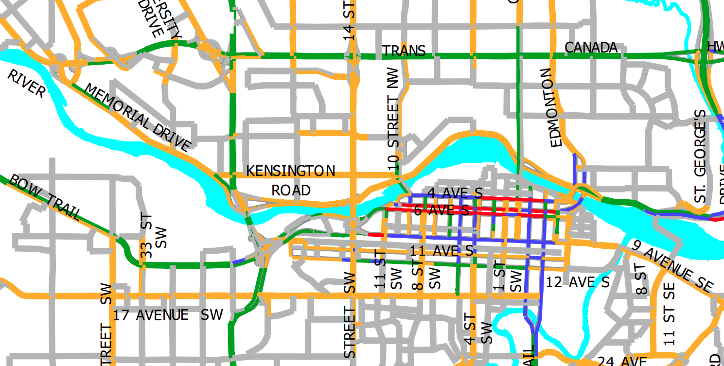
 
Isn't this mostly to do with the numerous north/south crossings and the fact the trains have to stop at traffic lights?

There should on really be 5 track crossings (Macleod North and South, 4th and 5th St., 8th St., and 11th St. (but only if the underpass is multi-mode).

Maybe that doesn't speed up the train that much and what do you do with pedestrians? But its something.
Once you're underground for the CP tracks I don't think it's a huge deal to stay there for another 5 blocks each north and east. I've mentioned several times that I would imagine some substantial savings by using 1 St SW instead of 2nd (retrofitting 1st st underpass instead of digging an entirely new tunnel; easier alignment to cross Bow River with less impact to PIP).

I still don't really understand how running at-grade down Centre St isn't going to suck in the short-mid term, especially for the many, many bus routes there. Is the plan forced transfers to train? Can busses run on the train 'lanes'?
 
grade separation of 14th Street SW, and the grade separation of Anderson Road
Here's an idea, leave them as is. Both very well served by transit. They just redid 14th, so at the very least don't touch that. Anderson being two interchanges, I could live with that.

You know what I don't see on that map? Crowchild from the river to 24th! Muahaha, maybe they won't spend a billion on it?!
 
retrofitting 1st st underpass instead of digging an entirely new tunnel
No way they take an underpass away from cars, I am only half joking when I say this.

I think they're wild if they actually bore and don't cut and over this thing.

Do you think the reduction in north/south crossings helps the blue/red lines?
 
If it was just a tunnel, would be somewhat easy. But stations, stations are what cost big big money underground.

forced transfers to the train are planned once the greenline gets to 64th.
Should only be 2 underground stations in downtown I think?

I'd rather they tunnel into McHugh Bluff and ditch the 9 Ave N station.
 
Should only be 2 underground stations in downtown I think?

I'd rather they tunnel into McHugh Bluff and ditch the 9 Ave N station.
Yeah. If there is failed procurement due to the tunnel, I suspect we will end up with something like the teal or pink below, elevated. Green is max slope which does allow for being deep enough by red, and having full 4.5m clearance for teal.
1660257481525.png


And getting to the middle of Centre St underground is worth it, then going elevated over 16th imo.
 
"Should" and "is" are very different things unfortunately (well, unfortunate, depending on your point of view). Still many, many, many interchanges left to be built in Calgary according to the long range plans. Just go to the "Anticipated Projects" section of the regional transportation model website to get an idea of this:

As a taste, here is the map for the 2046-2076 horizon. Download it yourself if you want to see the details, because you really need to be able to zoom in to get a sense of it all. What isn't obvious on that map, is the amount of projects built in the earlier horizons.
View attachment 419634

Some of those are regional and as a result, the responsibility of the Province. But things like the grade separation of 14th Street SW, and the grade speration of Anderson Road (not the intersection between these two, but ever intersection along these two) would be entirely on the City.

Here's an idea, leave them as is. Both very well served by transit. They just redid 14th, so at the very least don't touch that. Anderson being two interchanges, I could live with that.

You know what I don't see on that map? Crowchild from the river to 24th! Muahaha, maybe they won't spend a billion on it?!
That's because it's by 2039. ;)

1660353130753.png


I feel though that just because you see something on these maps, doesn't mean that it will get built. On the previous forecast form 2006, it has Sarcee TR SW connecting to Shaganappi TR NW through Edworthy Park. That's no longer in the plans.
 
I still don't really understand how running at-grade down Centre St isn't going to suck in the short-mid term, especially for the many, many bus routes there. Is the plan forced transfers to train? Can busses run on the train 'lanes'?
I suspect that current planners only really care about reaching 16th Ave in any fashion and will let somebody else in the future deal with the consequences. As it is, just to have any hope of getting to 16th within budget requires them to use the Option E that was rated poorly and rejected back in 2016.

1660359937021.png


Last edited:
I suspect that current planners only really care about reaching 16th Ave in any fashion and will let somebody else in the future deal with the consequences.
It's going to be above grade beyond 16th - otherwise the line will never get built with how costly it would be to fully tunnel. So is it that big of a trade off if it's at grade before it?
 
It's going to be above grade beyond 16th - otherwise the line will never get built with how costly it would be to fully tunnel. So is it that big of a trade off if it's at grade before it?
At least for the 2017 version, it being underground up to 16th Ave meant that bus and vehicle traffic wouldn't be impacted until money was available to go to 64th. And once construction could start, it would just be a few years of pain until buses could offload riders.

But with at-grade from the start, we could be looking at decades of pain (given the complete lack of any progress in the NC or prioritization) until money is available, not just for drivers but for all of the bus users of Centre Street N.
 
Last edited:

Back
Top