Me too. I don't think many people realize how much the river pathway has changed the feel of downtown/inner city Calgary in recent years. It's still not too late to add in some retail/resto action along the pathway in Eau Claire, if the willpower is there.... granted not many location available, but it can be done. Where Concord is now would have been the ultimate place for it, especially with the massively popular Peace Bridge. If the second phase of Concord doesn't get built, maybe it can be bought and re-purposed into mixed use?
Not to derail this thread too much from M2 but the city's draft plan for Eau Claire (which is open for feedback right now) does have the 1886 cafe relocating closer to the lagoon fronting on the pathway with a patio.
 
I think the differences in design shows how much mindsets (of developers, administrators and the public) have changed since 1980s Eau Claire and 2019 East Village. In the 1980s, a quasi-urban/suburban mall in the city centre was the hot idea. You see this with Eau Claire being set far back from the river and all the gated townhomes that could be plopped from anywhere, without a nod to the fact the river is right there. None of 1980s-era Eau Claire elevated the pathway beyond a nice thing to have but not worth changing designs over. The attractive qualities of the location never referenced the pathway system. To be fair to the folks before us, it would have been hard for developers and the public to make the call and focus development on the pathway too much: the pathway system wasn't nearly as complete as it is today nor ingrained in Calgary's psyche. INner city lifestyle wasn't much of a thing with declining population and auto-centric everything being in vogue. Much of the eastern section of the pathway (e.g. where M2 and East Village is) only came together in the late 1970s not to mention countless network/park quality improvements all over the place.

Fast forward to today. The river pathway has become the inner city's most consistently successful attraction to the point it is influencing the design, commuting patterns and social life of citizens. A whole generation of Calgarians grew up with an always-improving pathway network since 1980s Eau Claire, reinforcing the network in the collective conscious as part of life in the City. The urban population is booming and the Instagram-friendly Bow River is centre stage to many Calgarians.

I always thought the river pathway doesn't get enough credit for it's role in the city's evolution. It's helped immeasurable to create a more connected, pedestrian-focused and urban place. Despite all our auto-centric growth and missing connections - something that gets repeated attention in media etc. - the backbone of a high-quality, mostly grade-separated and highly connected river pathways system is one of Calgary's most important urban assets. I am glad developers are recognizing this with more intentional design choices like M2. I expect much more similar development to come in future years as well as with the recent and significant park/pathway bylaw changes being proposed.
well said!
 
IMG_3159.JPG
 
For a while I thought they might, but it feels like there has been little progress in the last three months.
 
Just the big visual stuff not happening maybe. All other work that you don’t notice a difference on going.
I guess there must be lots going on, I always see lots of guys around the site. It feels like there's some kind of delay with the exterior panels though.
 
Design > pop/job density
Bingo. I'll add that this is the type of design that enables pop/job density. Leftover little parcels and giant vacant stretches of our inner city shouldn't just sit vacant because we are waiting for the economics to be right for a mega tower or project. Let's fill them with something to complete the fabric.

As a digression but I will link it back to the project:
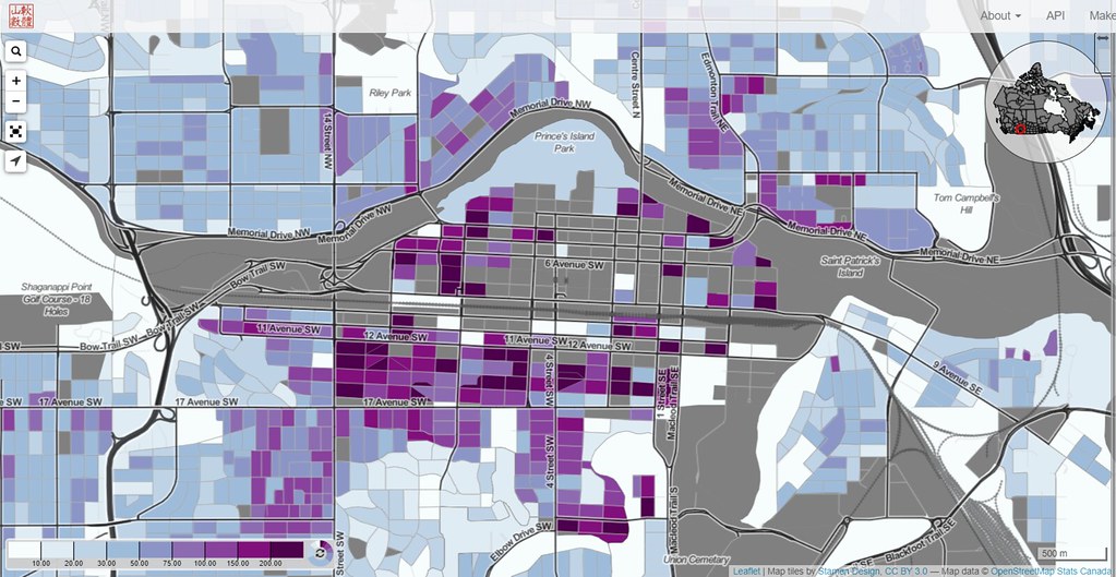
IMO most of Calgary's urban issues - I mean "issues" quite broadly including sustainability, vibrancy, culture etc. - stem from having too much empty space and too little continuous urban fabric. Not all of it is our fault - rivers and flood fringes, steep slopes boxing in the city centre - but lots of this excess space is - overly generous lawns, overly generous road setbacks, woefully unused Fort Calgary fields, surface parking, wide and empty roads, a endless demand for office-only buildings (until recently) etc.

This lovely Census Mapper tool helps illustrate this mapping at the block level People per Hectare for 2016. What to note here: look at how much grey there is. In grey areas, population = 0. So many breaks and discontinuity between areas of substantial population.

48104590267_bbcac6ab05_b.jpg


Smart little infills like this help fill the fabric. Let's not just compensate for the grey areas by only packing in as many as we can on the purple area, let's have less grey areas in the first place. Next let's have less low density barriers - Mount Royal, Briar Hill, Rosedale, Ramsay, Inglewood. Where it's likely for no or low-density to remain, let's use design to break the barriers and make passing between the purple parts easier and more enjoyable.
 

Back
Top