News   GLOBAL  |  Apr 02, 2020
 9.8K     0 
News   GLOBAL  |  Apr 01, 2020
 41K     0 
News   GLOBAL  |  Apr 01, 2020
 5.6K     0 

Sidewalk width is such an ongoing battle - on Dundas West where it goes NORTH of Bloor (parallel to the Go/UP tracks) the eastern sidewalk is a year-round struggle. When it snows, it's not plowed, and the rest of the year whatever the bushes are (weeds? I honestly don't know) encroach in a major way. I shudder to think what someone pushing a stroller, granny cart or using a mobility device would do. I suppose they'd opt for the other sidewalk and then do the oh-so-lovely song and dance of crossing at multi-step "The Junction" intersection.

View attachment 457992 View attachment 457993

I imagine some of the plant material shown was intentional, but its difficult to assess what was and was not.

The Goldenrod, a native plant, looks nice when in flower, not as nice the rest of the time, but is going to fall over in late season, and will lean in the direction of the sun prior to that. one can note the effect of an opaque sound wall in exaggerating the natural leaning effect. I certainly question putting in this mix of plants (if it was mostly intentional) as the encroachment was a foreseeable issue; and it looks more neglected than natural.

Ps, I think I'm safe in saying the very visible vine (large leaf, foreground) in the image on the left was not intentional; that's Wild (Riverbank) Grape. Native, but highly invasive, it will run over any other plant in its way, climb it and kill it. (in nature it encounters limits that prevent it from bulldozing everything, not so much in urban sites like this)
 
Sidewalk width is such an ongoing battle - on Dundas West where it goes NORTH of Bloor (parallel to the Go/UP tracks) the eastern sidewalk is a year-round struggle. When it snows, it's not plowed, and the rest of the year whatever the bushes are (weeds? I honestly don't know) encroach in a major way. I shudder to think what someone pushing a stroller, granny cart or using a mobility device would do. I suppose they'd opt for the other sidewalk and then do the oh-so-lovely song and dance of crossing at multi-step "The Junction" intersection.

View attachment 457992 View attachment 457993
Anyone pushing a stroller, granny cart, or using a mobility device will likely end up in the cycling lane. Which could be worse if there are rain puddles or potholes in the gutter.

BTW. Sidewalks were made so that people would not have to walk in the streets which was covered in horse manure and urine.

The automobile solved this crisis, but ended up with more deaths (by the automobile) and other problems (IE. smog).
 
For me it was an unfortunate fusion of front tire and streetcar track that took me down (sans helmet) and changed my usage pattern. I thought I had mastered the art of safely crossing tracks, but a bit of rain and trying to cross from a stopped position without forward momentum (making a left turn) allowed my tire to slide sideways and the whole bike hinged over. My shoulder took the brunt of the injury, but my temple hovering over the asphalt was enough to make me rethink things going forward. To each their own though, and I wish we had enough safe and separated cycling infrastructure where this wasn't a concern at all.
Agreed. though I was hit by a car on a bike lane on Danforth - so even separated can be deadly.
 
I don't believe I or anyone else reported on the Kipling Multi-use Path improvements (along Kipling, south of Steeles) that were completed last year. Apologies if my memory is failing, I just saw these noted by @H4F33Z on twitter and thought they were worth showcasing here. (images extracted by me from Streetview)

1677184604352.png


Here, below are a before and after pair:


1677184713644.png


1677184754425.png


Some nice stuff, though I hope they were planning on putting a shelter at that stop!

***

Worth saying here, this is, to my understanding, the design plan for Bathurst, Sheppard to Steeles.
 
This is encouraging. A few thoughts.

Glad to see the aggressive curbs. These aid a lot in slowing down turning drivers.

I find the cyclist volume isn't terribly high on similar lanes in my area. In practice, people use them more like an expanded sidewalk. But that's also pretty helpful.

Looks like there's room to steal another 20-30cm from each car lane. Would help lower speeds and expand the sidewalk.

Trees and shrubs in the grassy shoulders where there's enough room would be good.

We need to get the details right on these things. When I used to cycle, I found sight lines were an issue. You're moving much faster than a pedestrian and come up pretty fast on cross streets/driveways. Can make for unwelcome surprises and conflicts with turning traffic. I'm still seeing some pinch points in this design. Maybe our development regs should force better sight line (and curb) design for all new developments.

Raised crosswalks with illumination: many crossings are very dark at night. Raised crossings would also work in tandem with curb extensions to slow turning traffic.

And maybe one day we'll get around to burying utility wires (be still my beating heart). Also ensure all surfaces are plowed in winter and paving is well maintained. Finally, we can't install stretches like this and call it a day. These lanes must lead to relevant destinations/trip generators and connect with each other along major arterials (build a network).
 
Last edited:
I don't believe I or anyone else reported on the Kipling Multi-use Path improvements (along Kipling, south of Steeles) that were completed last year. Apologies if my memory is failing, I just saw these noted by @H4F33Z on twitter and thought they were worth showcasing here. (images extracted by me from Streetview)

View attachment 458291


Here, below are a before and after pair:


View attachment 458292

View attachment 458293

Some nice stuff, though I hope they were planning on putting a shelter at that stop!

***

Worth saying here, this is, to my understanding, the design plan for Bathurst, Sheppard to Steeles.
How long are those lanes? Do they connect to anything useful?
 
How long are those lanes? Do they connect to anything useful?

1.5km long.

This section of Kipling:

1677188320577.png


It doesn't connect a lot of major stuff, but there is some. Lots of high density residential. Rabba, a couple of strip plazas, one indy supermarket and more or less gets to one public high school (North Albion) and one Catholic Elementary school (just south of this project)
 
1.5km long.

This section of Kipling:

View attachment 458298

It doesn't connect a lot of major stuff, but there is some. Lots of high density residential. Rabba, a couple of strip plazas, one indy supermarket and more or less gets to one public high school (North Albion) and one Catholic Elementary school (just south of this project)
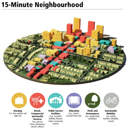
One of many steps towards a 15-minute neighbourhood?

See link.

1-Ottawa_e.png

See link.
 
Need to move away from the corporate controlled malls and their high store leases. Let hairdressers or barbers set up shop in their basement, for example.

Walter, this is not the zoning reform thread; nor is it the 15-minute city thread; its the cycling thread.

I'm an advocate for the ideals embraced in the 15-minute city vision; but can we not see posts about it here, there and everywhere, please?
 
I don't believe I or anyone else reported on the Kipling Multi-use Path improvements (along Kipling, south of Steeles) that were completed last year. Apologies if my memory is failing, I just saw these noted by @H4F33Z on twitter and thought they were worth showcasing here. (images extracted by me from Streetview)

View attachment 458291


Here, below are a before and after pair:


View attachment 458292

View attachment 458293

Some nice stuff, though I hope they were planning on putting a shelter at that stop!

***

Worth saying here, this is, to my understanding, the design plan for Bathurst, Sheppard to Steeles.

Looks great. Every suburb street of Toronto with curb space needs this; or one direction on each side of the street if there isn't room for this MUP style.
 
Last edited:
Walter, this is not the zoning reform thread; nor is it the 15-minute city thread; its the cycling thread.

I'm an advocate for the ideals embraced in the 15-minute city vision; but can we not see posts about it here, there and everywhere, please?
Cycling is actually better in a 15-minute neighbourhood. Don't need a car to get most services or goods, when a bicycle is the way to transport oneself. Cycling infrastructure is a big part of any 15-minute neighbourhood.
 
Last edited:
There has often been some discussion on this thread (and others) related to access for city emergency services on narrower streets vs the size of the emergency vehicles attending. Here's a solution from Japan (Courtesy of Car and Driver) A Honda ACTY Fire Truck. Currently on auction and the bid level is a mere US$11,500 - but you need to go and pick it up. Comes with spares. The wheel base is about 2.4 meters, the overall length about 3.4 meters and the width about 1.5 meters. Comes equipped with 6 wheels (summer) or front wheels and rear tracks (winter and off-roading I imagine) I think when it was fully outfitted the truck would carry a couple of ladders, a reel and hose, pump and connections for Hydrants and basic emergency equipment..

https://www.caranddriver.com/news/a...y-crawler-fire-truck-bring-a-trailer-auction/
167b3ce2-edab-44a5-973c-9fd6d96f03bb-53746-scaled-1677186085.jpeg
 

Back
Top