News   GLOBAL  |  Apr 02, 2020
 9.6K     0 
News   GLOBAL  |  Apr 01, 2020
 41K     0 
News   GLOBAL  |  Apr 01, 2020
 5.4K     0 

1594063884336.png

From link.

The "original" Canadian National Exhibition was on the west end, where the older buildings are located, with grass surrounding them, west of Ontario Drive. The portion on the east side was the Fort York Garrison which was bulldozed for the Automotive Building, Coliseum, etc. and parking lots. Emphasis on "parking".

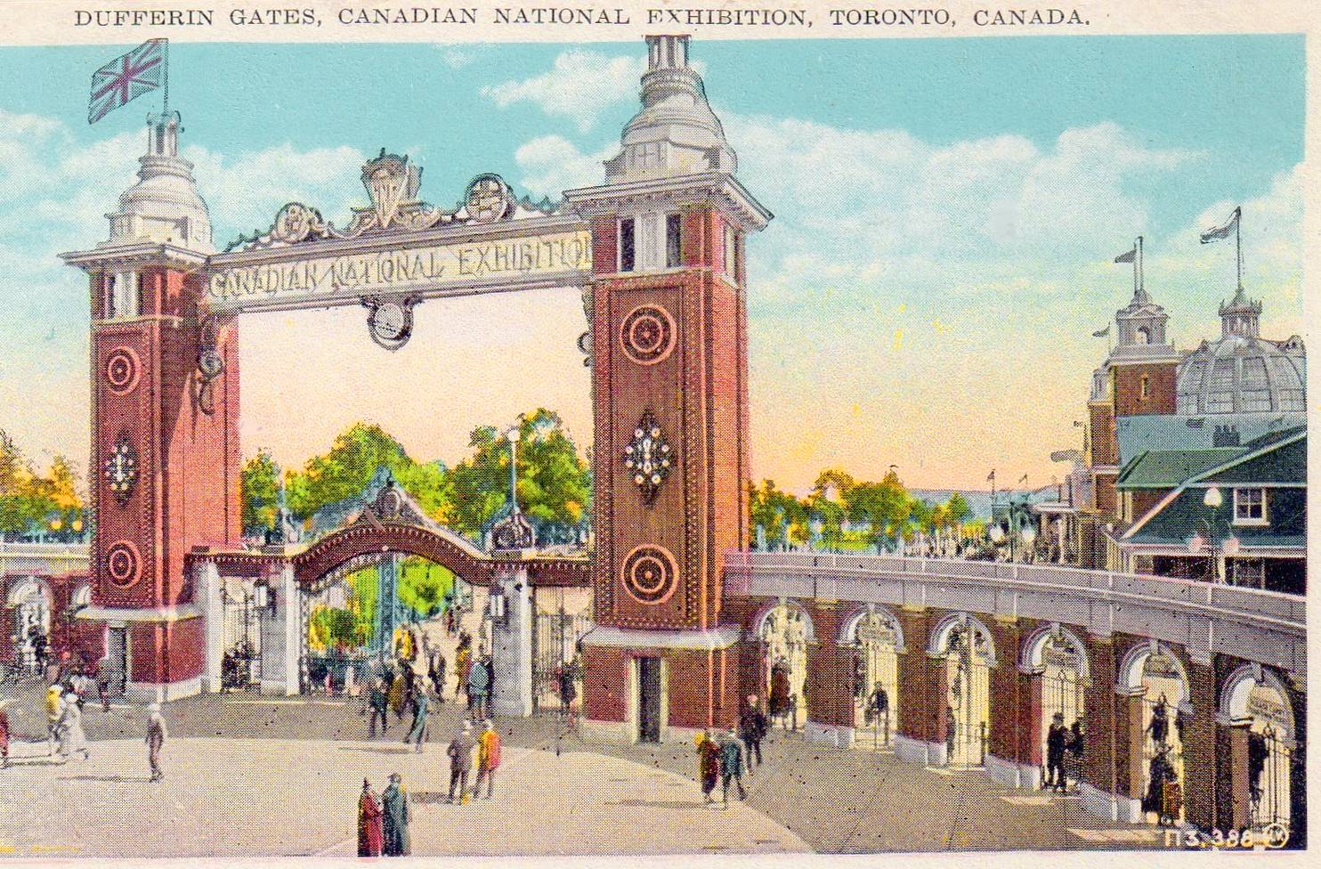
The current Dufferin Gates aren't even being used as "gates" anymore. They went up as a replacement to make way for the Gardiner Expressway.

POSTCARD+-+TORONTO+-+EXHIBITION+-+DUFFERIN+GATES+-+1920s.jpg

From link.
 
Last I checked there's also a vast amount of land that will be available by the Portlands that the city has at their disposal, no? That's unless the city squanders that opportunity as well.

The bigger problem this city has, is the piss poor low amount of density this administration has been aiming for on itS affordable land plots. They like to claim that "developers won’t build if we seek higher affordability targets". Obviously that claim is flawed for various reasons, and if it was true then ok: allow for denser projects to proceed. There's no reason we need to go looking for more plots to develop, when the plots of land the city already has at theor disposal is already being squandered.
 
I think I wrote in the Ontario Place thread quite some time ago that the Exhibition lands need a drastic re-think of how uses are organized, in a way that might be unpopular because of what structures and trees it might displace.

Here's a quick mock-up, I re-aligned LakeShore through the grounds. Maybe the intersection at Dufferin is too close to the bridge but I didn't see a significant incline. Princes' Gate would have to be painstakingly and carefully relocated.

This would free up lots of land for development, and space left-over for reprogramming space at the EX.

1594135567070.png
 
Plus I am not sure what's the gain from this - there is nothing preventing the parking lots at both the Ex and OP from getting developed (case in point - Hotel X)- it doesn't require re-routing Lake Shore. You could have easily achieved the same with a land bridge in the central portion.

AoD
 
I think I wrote in the Ontario Place thread quite some time ago that the Exhibition lands need a drastic re-think of how uses are organized, in a way that might be unpopular because of what structures and trees it might displace.

Here's a quick mock-up, I re-aligned LakeShore through the grounds. Maybe the intersection at Dufferin is too close to the bridge but I didn't see a significant incline. Princes' Gate would have to be painstakingly and carefully relocated.

This would free up lots of land for development, and space left-over for reprogramming space at the EX.

There.. fixed it for you.. :))
1594135567070-1.jpg
 
West of Exhibition Place (used to be called Exhibition Park), was South Parkdale.

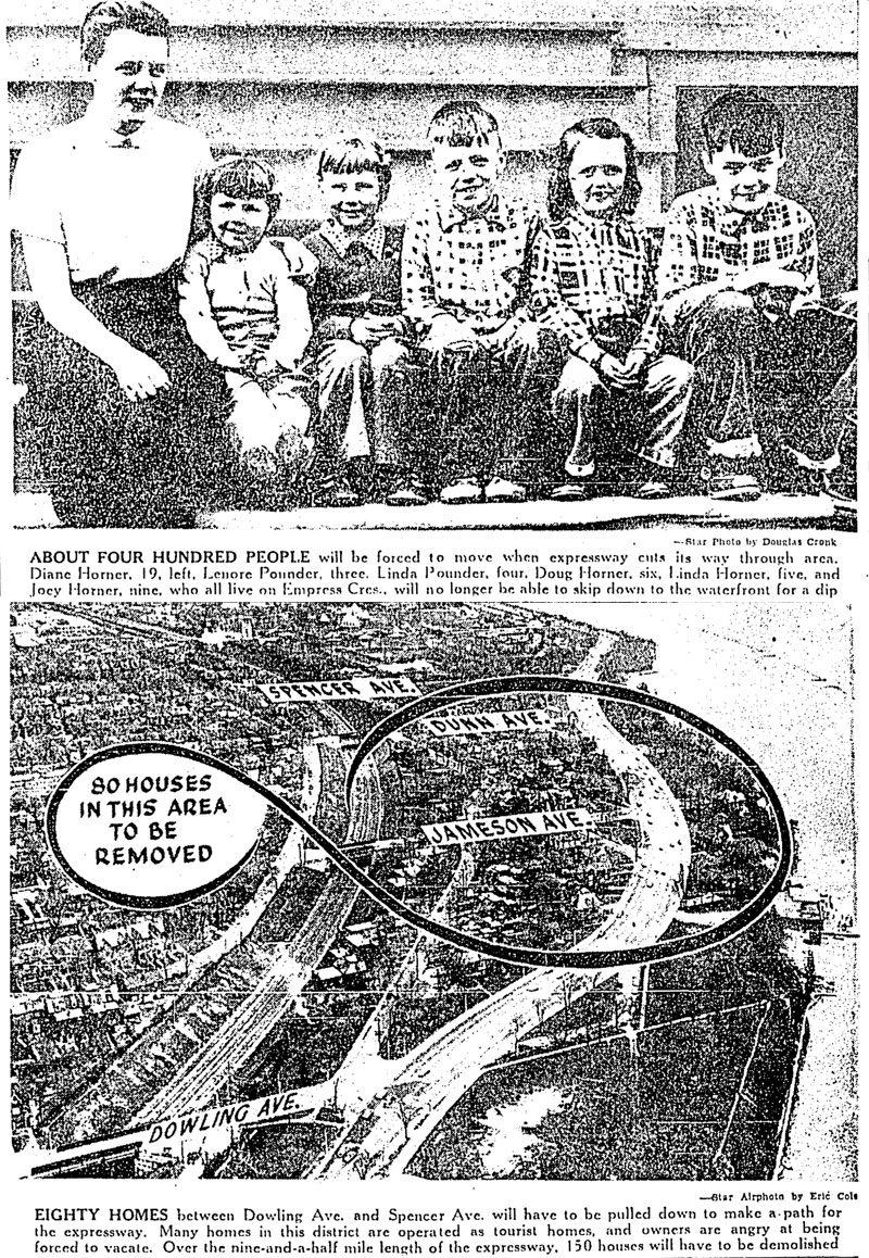
20170302-LostStreets-StarCombo.jpg


The Toronto Star interviewed residents of South Parkdale in 1954 about the impending destruction of their neighbourhood. Some were sad, others were happy with a cheque. Image: Toronto Daily Star, May 4, 1954.

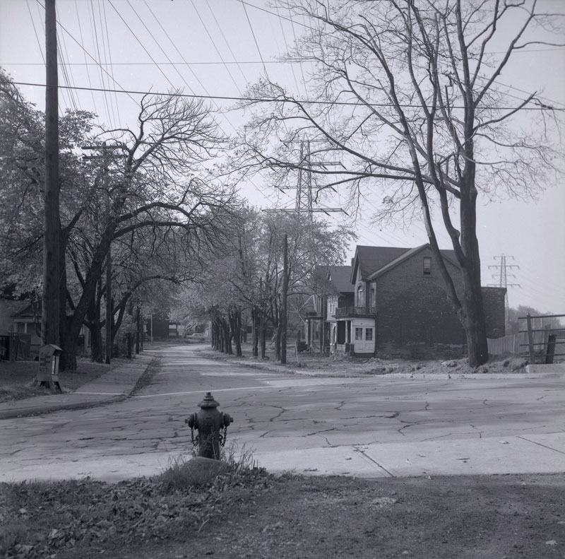
20170302-LostStreets-Empress-Alt.jpg

Empress Avenue looking west from Dunn Avenue in 1956. Construction of the Lakeshore Expressway began the same year. Image: Toronto Public Library, S 1-4093.

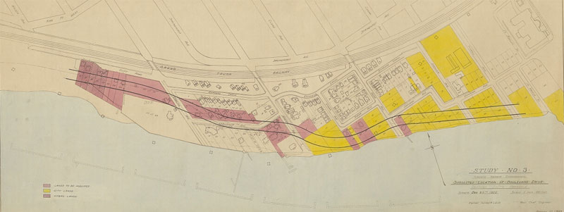
20170302-LostStreets-AreaMap-Alt.jpg

The planned path of Lake Shore Boulevard (then known as Boulevard Drive) through South Parkdale, December, 1920. Image: City of Toronto Archives, Fonds 200, Series 724, Item 166.

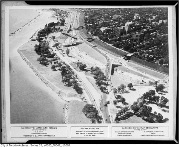
20170302-LostStreets-Aerial-600x494.jpg

South Parkdale during construction of the Gardiner Expressway in August, 1958. Image: City of Toronto Archives, Fonds 220, Series 65, File 47.

The lost streets of South Parkdale

From link.

No Toronto neighbourhood paid for the Gardiner Expressway quite like Parkdale.

Before construction of the lakefront highway in 1958, the land south of Springhurst Avenue and the rail tracks was just like the rest of Parkdale: residential, consisting of mostly detached homes on spacious lots.

At the time, Dunn and Jameson Avenues passed over the rail tracks south to the waterfront and a tangle of smaller streets such as Laburnam and Starr Avenues, Empress Crescent, and Hawthorne Terrace intersected them.

South Parkdale was distinct enough to have its own railway station near the present-day foot of Close Avenue.

The first major road to penetrate the neighbourhood was Lake Shore Boulevard, which snaked south of Exhibition Place along the waterfront toward the Humber River in the 1920s.

In South Parkdale, Lake Shore Boulevard was created by merging and widening a number of residential streets, including Laburnam Avenue and parts of Starr Avenue.

There are subtle clues to the existence of these old streets. Lake Shore Boulevard subtly winds in the area north of Marilyn Bell Park, mirroring the former the routes of these lost streets.

The clearest example of this is where Lake Shore Boulevard turns sharply north to avoid the Toronto Sailing and Canoe Club near Dowling Avenue.

For the next few decades, South Parkdale remained relatively stable. Lake Shore Boulevard was five lanes wide and often busy with traffic, but houses and driveways still lined the route. The eventual destruction of the neighbourhood came in 1956, when construction began on the Lakeshore Expressway.

About 150 homes and 400 people were forced to make way for the expressway when the route was announced in 1954.
For Dorothy Wood, who lived on the south end of Jameson Avenue, it was just history repeating itself. When she was young her parents’ home was expropriated for Lake Shore Boulevard.

“When they pulled down our house for Lake Shore Boulevard, we moved into this house,” she told the Toronto Star. “I like the location. It is cool in the summer—I don’t know where I could find another place like it in Toronto.”

Mrs. K. B. McKellar of Starr Avenue expressed similar feelings. “I love it here. I don’t want to move,” she said. “We have a very nice garden and a very pleasant view of the lakefront.”

Mr. C. L. Ellis, who operated a tourist property in the neighbourhood, took the news with a shrug. “If they hand us a big enough cheque for this property, we won’t kick too much,” he said. “But we’ve been here four years, we’ve put a lot of money into the place and we like the location.”

In 1956, photographer James Salmon pictured the condemned streets shortly before construction on the expressway began. The roads and sidewalks were empty and the yards overgrown and strewn with leaves. Within weeks, it was all gone.

To make a path for the Gardiner through South Parkdale, almost all the streets south of King and west of Dufferin were demolished. The houses on Starr Avenue, Laburnam Avenue, Empress Crescent, and others were all torn down and the trees, sewers, and fire hydrants removed.

Workers dug a trench for the new highway to the south of the rail corridor, creating a stark landscape that captured the imagination of a young novelist, playwright, and poet Milton Terrence Kelly.

“Parkdale was a construction site. All the Victorian homes, including the one next door to where my best friend lived, were being torn down for apartment houses,” he recalled.

“The great trench of the Gardiner went through, cutting us off from the Lake. While it was being built, we played there, pretending we were wolves; the ramp led up and fell off, as eerie and windswept as a desert.”

The area didn’t stay quiet for long. When the road opened in 1962, cars and trucks filled the highway and its access roads. Lake Shore Boulevard bloated to its current proportions, essentially acting as a second parallel expressway.

The former location of South Parkdale is now so dense with highways, feeder roads, overpasses, and traffic noise it’s difficult to imagine a time when it was anything like the rest of Parkdale.

Toronto mayor John Sewell and Metropolitan Toronto chairman Paul Godfrey announced a plan with the potential to bring back South Parkdale in 1979.

At their direction, city planners studied the feasibility of covering over the Gardiner and rail corridor between Dowling Avenue and Exhibition Place, creating about 40 acres of new land for residential development.

Drawings from the resulting report showed mid-rise buildings on a restored South Parkdale street grid north of Lake Shore Boulevard.

“To encase the rails and road would indeed be grandiose,” wrote Globe and Mail columnist Dick Beddoes. “We’d have a mile-long covered corridor, which presumably, we’d call the Godfrey-Sewell Secret Passage. Or Tunnel Job.”

He clearly didn’t think much of the idea.

The tunnel plan was projected to cost somewhere in the region of $25-million, according to Parkdale councillor Barbara Adams, but nothing much came of it save for some paperwork.

South Parkdale will have to wait for its return.

Just before where the Gardiner Expressway is today in a trench and rises up to become elevated, it was part of Exhibition Park (today, Exhibition Place), now lost.

Part of the northern section could become part of the Lake Shore LRT extension west from the Exhibition Loop. Too bad they couldn't take part of the Gardiner Expressway, or at the very least cover the Gardiner Expressway trench for the streetcar track extension.
 
Were there any shops in South Parkdale or just houses?

Before zoning rules, there were little shops, beauty or barber shops, or doctors/dentist offices at many corners. That's how Kensington Market started out as. Now because of zoning, high commercial property taxes, and NIMBYs, that has almost disappeared. You can see converted stores that are now residential in the old parts of Toronto.
 
Get the 905ers to pay for the destruction they have put on Exhibition Place (Park).

Road tolls on the Gardiner? Some ways Queen’s Park can help Toronto with its $1.5B pandemic budget crisis

From link.

Big number: $272 million, the estimated amount Toronto could raise each year by implementing a $4 per trip toll on the Gardiner and Don Valley Parkway. If Queen’s Park gave Toronto authority to issue tolls or taxes like this, city hall would be in a position to deal with budget pressures related to COVID-19.

In his quest to get Prime Minister Justin Trudeau and Premier Doug Ford to pony up some cash to deal with the estimated $1.5 billion (or more) pandemic-related fiscal hole Toronto will be in at the end of the year, Mayor John Tory has been trying all kinds of strategies.

Some days he takes a stern approach, laying out scenarios of doom if the city doesn’t receive funds — closure of subway lines and library branches, laid off firefighters, shuttered homeless shelters. Other days he plays the role of ego-soothing mediator, praising Ford while admonishing Trudeau, or vice versa.

On days when one of the governments has announced a bit of funding — like last Thursday’s provincial announcement of $150 million in shelter and housing funds for Ontario municipalities — he’s like a patient dad lavishing encouragement on a child who has managed to put a sock on, describing it as a really great start toward finally getting dressed.

I won’t knock the mayor for any of this. He’s doing what he has to do in the face of a $1.5-billion problem. But let’s be real: it’s demeaning to see the leader of Canada’s largest city have to ask for money like this.

It doesn’t need to be this way. The provincial government could empower Toronto to solve this problem mostly by itself by making two changes to legislation.

The first move would be to permit Toronto to run operating budget deficits. Currently, unlike provincial and federal governments, Toronto is not allowed to pass a budget that is not balanced. If the government of Prince Edward Island, population 157,000, can be trusted to run deficits when times are tough, Toronto, with a population of almost 3 million, can probably handle it.

But don’t stop there. Allowing city hall to post deficits without the tools to increase revenue to pay down those deficits over time would just make the situation worse. Instead, the provincial legislature could pass an amendment to the City of Toronto Act expanding the kinds of taxes and fees Toronto is permitted to implement.

Don’t be restrictive. Give the city options and let Toronto council make choices.

For example, council might choose to re-examine highway tolls. A toll on the Gardiner Expressway and Don Valley Parkway, something Tory advanced in 2016 before he was blocked by then-premier Kathleen Wynne, could raise about $272 million a year if tolls were set at about four bucks a trip according to estimates. That’s enough to pay down $1.5 billion of pandemic debt in about six years.

Or if tolls aren’t your thing, try something new — most cities of Toronto’s size aren’t as reliant on property taxes to pay for services. A 2016 study by KPMG looked at alternatives and found a Toronto sales tax of 1 per cent could raise a similar amount to highway tolls — about $261 million. A 1 per cent municipal income tax could raise between $580 million and $926 million, depending on implementation. A parking levy that taxes all parking spots in Toronto to the tune of $1.50 per day could raise about $535 million. Not too shabby.

There are downsides to any new tax or toll, of course. Implementation would need to be carefully balanced to make sure economic recovery from COVID-19 isn’t hindered.

But there are also upsides. Tolls or taxes that generate revenue that grows with the economy would motivate city hall to encourage economic activity. Local politicians would have a budgetary reason to push for events and policies that convince people to come to Toronto and spend money at local businesses.
It’s a longshot that Ford would ever even consider making these moves, but there could be an upside for Queen’s Park too. For decades, Toronto mayors have spent much of their time in office cajoling Ontario premiers for funding for various things.

A move to empower Toronto could finally change that relationship. The premier could focus on province-wide issues and the mayor could stop with the asking and start with the doing.
 
There was a plan to shift the alignment of Lake Shore just beyond the western end of the Ex and consolidate the fragmented green space - I wonder what happened to that.

AoD
 
There was a plan to shift the alignment of Lake Shore just beyond the western end of the Ex and consolidate the fragmented green space - I wonder what happened to that.

AoD
Shifting Lake Shore and removing some of the Gardiner ramps is an absolute must in repairing that urban space, but I think it's more of an 'it ain't that broken' situation.

Since no one really lives there nor is the space frequented (as an effect of the urban desolation), city funds are prioritized elsewhere.

Oh my god, what I would give...

NO%2306-220145-05+Clemens+Gritl

Considering the way these buildings are depicted (which is not the way architects like Le Corbusier would have depicted their utopias), more of a cautionary vision!
 
  • Like
Reactions: max

Back
Top