News   GLOBAL  |  Apr 02, 2020
 9.7K     0 
News   GLOBAL  |  Apr 01, 2020
 41K     0 
News   GLOBAL  |  Apr 01, 2020
 5.5K     0 

  • Thread starter fiendishlibrarian
  • Start date
Re: Bloor Danforth subway 1966

That last picture shows that we really didn't lose much of interest on that stretch of Queen.
 
Re: Bloor Danforth subway 1966

True, but look at those cobbled streets! What a great little district that whole Eaton's complex could have become, like a Distillery District right in the middle of downtown. Does anyone know what happened to that tunnel under Albert Street? A PATH predecessor?
 
Re: Bloor Danforth subway 1966

Wouldn't that tunnel be part of the Eaton Centre today?

And you're right about what a great district it could have been. The west side of Yonge looked great in the archival pictures I saw.
 
Re: Bloor Danforth subway 1966

So Louisa Street was eliminated with the construction of Eaton Centre and City Hall?
 
Re: Bloor Danforth subway 1966

Fiendish,

Thanks for your efforts in researching and sharing these pics. My wife (UoT MLS, Archivist) and I (ignorant bloke) very much appreciate them.

Cheers for now!
 
Re: Bloor Danforth subway 1966

Ed>I dunno -- right along queen there was the Casino and a couple other infamous Toronto places -- un-Toronto-the-good places.
 
Re: Bloor Danforth subway 1966

Does anyone know what happened to that tunnel under Albert Street? A PATH predecessor?

Apparently, that tunnel is still there, connecting the Eaton Centre to the Bell Trinity building. I always wondered why that tunnel was so oddly placed (it would have been much shorter and more direct had it been placed further north), but I guess the reason is because it once connected the Eaton's main store to the Eaton's Annex.

Some cool photos of the Annex building and surroundings at: Eaton's Annex

So Louisa Street was eliminated with the construction of Eaton Centre and City Hall?

According to Wikipedia, in respect of the Eaton Centre: "Terauley Street, Louisa Street, Downey's Lane and Albert Lane were closed and disappeared from the city street grid to make way for the new complex. Albert Street and James Street were preserved only to the extent of their frontage around Old City Hall (although the city of Toronto required that pedestrians be able to cross through the mall where Albert Street once existed, at any time 24 hours a day, seven days a week, and pedestrians still enjoy this right today). Trinity Square lost its public access to Yonge Street, and became a pedestrian-only square with access via Bay Street."

What a great little district that whole Eaton's complex could have become, like a Distillery District right in the middle of downtown.

Maybe. The area does look great in the old photos. I have read, however (I think in the McQueen book on the Eaton's, but perhaps somewhere else) , that the old Eaton's Main Store was practically falling down by the 1960s. At some point that decade, Eaton's had to fill some of the old stairwells with concrete to add structural support. The Main Store had been cobbled together through so many additions since the 1870s that I have no doubt it wasn't in the greatest shape. And I suspect that the surrounding warehouse buildings weren't in any better shape. Once R.Y. stepped down in the 1940s, and John David took the helm of the chain, Eaton's ceased to be a good manager of its holdings. The Annex looks great in the old photos, and that might have been in better shape had it not burned down.

The Eaton Centre wasn't so much a money-making venture, or the highest and best use of the land, but I am sure it was also seen at the time as a necessity given the state of the existing buildings. Renovating those soot-covered buildings (not to mention the fact that the Main Store was painted battleship grey in the early 1970s), and spending all that money to render them structurally sound, would have required a lot of imagination and dedication to heritage, both of which were sadly lacking in the 1970s both generally, and specifically in the Eaton's head office suites.
 
Re: Bloor Danforth subway 1966

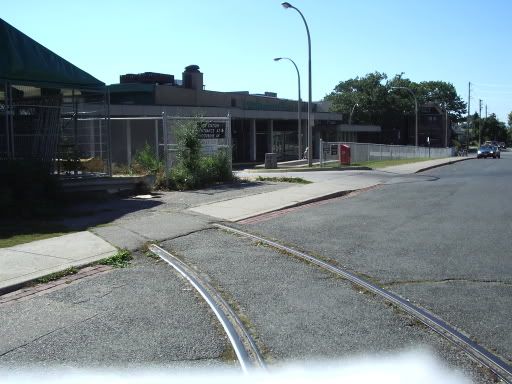
2004-09-26subwaytour086.jpg

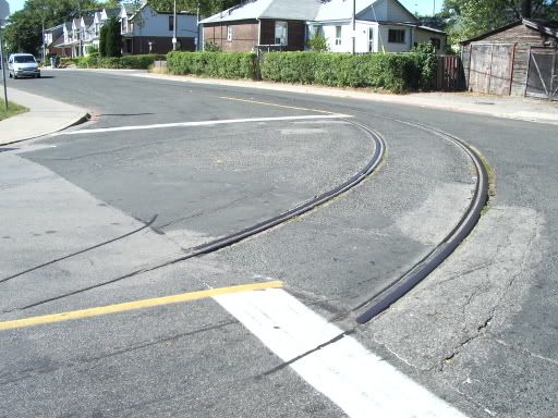
2004-09-26subwaytour085.jpg


Above are pictures of the remaining streetcar tracks at Woodbine station. The first picture is on Strathmore Bvd. with the tracks turning into the former Streetcar teminal(now a parking lot) with Woodbine station bus terminal in the background.

The second picture is where the tracks fade away at the corner of Strathmore and Cedarvale.
 
EVERYONE: This is quite an archive of Toronto history! Everyone can see the amazing changes that Toronto made in becoming Canada's People City. LI MIKE
 
It's kind of depressing to see some of those 50s/60s era buildings in thier heyday, knowing how shabby a lot of this stuff is today.

It is often said that Toronto could be a prim, stifeling place in those days (and I'm sure it was). But you can't help but admire the achievments of these people - we are still operating to a large degree on the legacy infrastructure that was built back then.

The city has grown and is more interesting but it also a LOT uglier and it just doesn't seem to function as smoothly as it once did. Why could they build miles of subway back then and we can't even seem to organize an LRT grid in a city that is much richer/larger?

It should be noted that from 1951-1971, Toronto's population doubled. That massive growth had a lot to do with it. We haven't seen such a jump in population since then.
 
This is actually looking up James Street, from Queen Street West. Albert Street runs in front of the Eaton's Annex and (presumably) the wall of buildings marking Louisa Street is visible further up.

Originally, the name of the office building erected at the south end of the Eaton Centre was to be the Queen James Tower until some spoil sport at Cadillac Fairview nixed the idea.
 

Back
Top