News   GLOBAL  |  Apr 02, 2020
 9.8K     0 
News   GLOBAL  |  Apr 01, 2020
 41K     0 
News   GLOBAL  |  Apr 01, 2020
 5.6K     0 

What??? I’m talking about these bridge spans Dropped pin https://goo.gl/maps/rCUSiGSCNdTZ3xX39 At Wilson and Norfolk (NOT Speed River) that are slated for replacement by Metrolinx. These 2 spans have one track but are wide enough for a 2nd track right now but are old and need to be replaced. The 2nd track is currently in place to Wyndham st and is used as a sliding by rail cars for grading cars (gravel is in them) and other equipment. There’s no sense in laying the 2nd track west right now when Wilson and Norfolk Spans will be replaced. Metrolinx has cleared the land of bush but won’t do anything else until those spans are replaced.
All the information I have about this work is from chatting with city staff and the public information is available here: Metrolinx in Guelph in the City of Guelph website.
 
I had reason to ride the Barrie line today, and noted that grading for double tracking has begun in earnest feom Downsview Park all the way to Lawrence. Some noise wall installation is under way.

Down at Davenport, I counted 15 complete pairs of collunns (including the two purple forms) and 11 pairs of foundations waiting. So that’s roughly half way complete. The north embankment to the CP overpass continues to rise. Bridge foundations at Bloor are still a work in progress.

- Paul
 
^To repeat what has been posted before, the double track in Guelph is expected to run from Hanlon to the depot. That gives a nice long passing zone which enables a couple minutes of contingency in the schedules. The other bridges in that zone will be renewed in the near future. No other double tracking will happen at this time.

If you look at the peak schedules, that Guelph passing track alone will not enable counter peak service, because the headways will not allow a counter peak train to run Georgetown to Guelph without doing some additional passing. Same with Guelph-kitchener. Apparently, additional sidings are in the works. I was told procurement for these is also imminent, not sure if it’s one big tender for all the work vs multiple.

It’s happening, one step at a time.But full double tracking is a long ways off.a

- Paul
I'm a bit unfamiliar with the street names in the area. Perhaps someone could show on a map where this is?
 
I'm a bit unfamiliar with the street names in the area. Perhaps someone could show on a map where this is?

Should be this, as I understand it:

1634159789393.png


Hanlon is Hwy 6, the bright orange.

The depot, I'm assuming refers to Guelph Central Stn.

Wilson and Norfolk are intermediate, intersecting streets that the tracks bridge over.
 
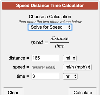
For those who may wish to try their hand at calculating time savings from speed improvement, here's a neat little tool:


You can set any two parameters and solve for the third.

ie. You can set the distance of track, in km or miles, then you can the speed in km/ph or mph, and the calculator can solve for time.

Saves the hard math.

* note, if your doing this with track segments that include stations, you will need to factor that the maximum speed permitted may not the constant speed. This will be particularly true where significant maximums are permitted.

That said, its a good short-hand cheat.

I find that, as my brain softens with age, online calculators - which seem to be available for just about anything now - are a real benefit.
 
I find that, as my brain softens with age, online calculators - which seem to be available for just about anything now - are a real benefit.
I have an engineering degree, but I'm sure if we got the acceleration rate of the Go Train and deceleration rate, and assume constant speed of the train once it's at speed. You could get a pretty accurate picture of the time between stations.
 
If you look at the peak schedules, that Guelph passing track alone will not enable counter peak service, because the headways will not allow a counter peak train to run Georgetown to Guelph without doing some additional passing. Same with Guelph-kitchener. Apparently, additional sidings are in the works. I was told procurement for these is also imminent, not sure if it’s one big tender for all the work vs multiple.

It’s happening, one step at a time. But full double tracking is a long ways off.

True, the Guelph siding alone isn't enough to get counterpeak service past the 30-minute peak service, but combined with a passing opportunity at Georgetown it's enough for hourly off-peak service in both directions, given that Guelph and Georgetown are precisely 30 minutes apart.
d.JPG


Georgetown station was supposed to be reconfigured this year, but I haven't heard anything on that recently. It's possible that those plans have been put on hold pending decisions on the future track configuration resulting from the planned GO-to-CN flyover between Georgetown and Mount Pleasant.

In the meantime, it seems like we could make a quick-and-dirty passing location at Georgetown simply by lengthening the south (VIA) platform to support GO trains. The existing track configuration would allow the eastbound and westbound GO trains to cross CN traffic simultaneously there, operating on the south track east of the station. This leaves the remaining 50-minutes per hour free for CN trains to pass through. The Kitchener line business case implies that CN has agreed to hourly GO service with this type of operation, even prior to the flyover being built.

West of Georgetown, the Metrolinx Guelph subdivision joins into the CN Halton Subdivision from the north - eastbound trains would cross over here to reach the south CN track. Westbound trains would stick to the GO track on the north side of the corridor.
a2.jpg


There seems to be enough space to lengthen the south platform to GO's standard length of 314 metres. Eastbound and westbound trains would meet here.
b2.jpg


East of Georgetown, GO would operate on the south track in both directions, avoiding any further conflicts with CN. The Metrolinx Weston subdivision splits off to the south at Bramalea.
c2.jpg


Given how quick it would be to lay down a temporary platform extension at Georgetown, I figure that hourly midday service could begin as soon as the second platform at Guelph station is complete.

As for counter-peak service, Metrolinx has also stated that they will build a passing track at Acton, which would then provide sidings every 15 minutes along the line. There is already a passing track 15 minutes west of Guelph, located just east of Kitchener Station. That would allow an hourly counterpeak service to meet the half-hourly peak service.
 
Last edited:
True, the Guelph siding alone isn't enough to get counterpeak service past the 30-minute peak service, but combined with a passing opportunity at Georgetown it's enough for hourly off-peak service in both directions, given that Guelph and Georgetown are precisely 30 minutes apart.
View attachment 355835

Georgetown station was supposed to be reconfigured this year, but I haven't heard anything on that recently. It's possible that those plans have been put on hold pending decisions on the future track configuration resulting from the planned GO-to-CN flyover between Georgetown and Mount Pleasant.

In the meantime, it seems like we could make a quick-and-dirty passing location at Georgetown simply by lengthening the south (VIA) platform to support GO trains. The existing track configuration would allow the eastbound and westbound GO trains to cross CN traffic simultaneously there, operating on the south track east of the station. This leaves the remaining 50-minutes per hour free for CN trains to pass through. The Kitchener line business case implies that CN has agreed to hourly GO service with this type of operation, even prior to the flyover being built.

West of Georgetown, the Metrolinx Guelph subdivision joins into the CN Halton Subdivision from the north - eastbound trains would cross over here to reach the south CN track. Westbound trains would stick to the GO track on the north side of the corridor.
View attachment 355836

There seems to be enough space to lengthen the south platform to GO's standard length of 314 metres. Eastbound and westbound trains would meet here.
View attachment 355837

East of Georgetown, GO would operate on the south track in both directions, avoiding any further conflicts with CN. The Metrolinx Weston subdivision splits off to the south at Bramalea.
View attachment 355838


Given how quick it would be to lay down a temporary platform extension at Georgetown, I figure that hourly midday service could begin as soon as the second platform at Guelph station is complete.

As for counter-peak service, Metrolinx has also stated that they will build a passing track at Acton, which would then provide sidings every 15 minutes along the line. There is already a passing track 15 minutes west of Guelph, located just east of Kitchener Station. That would allow an hourly counterpeak service to meet the half-hourly peak service.
When I rode the train to and from Kitchener last week, the train was no longer switching at Georgetown but instead switched tracks at Norval (just west of Mount Pleasant). As well track 3 at Mount Pleasant is now a throughput track.
 
This is all nice, but until Metrolinx pays CN the 1 billion or so to get the space in Brampton GO they cannot expand service imo.
 
Last edited:
In the meantime, it seems like we could make a quick-and-dirty passing location at Georgetown simply by lengthening the south (VIA) platform to support GO trains. The existing track configuration would allow the eastbound and westbound GO trains to cross CN traffic simultaneously there, operating on the south track east of the station. This leaves the remaining 50-minutes per hour free for CN trains to pass through. The Kitchener line business case implies that CN has agreed to hourly GO service with this type of operation, even prior to the flyover being built.

The "plan" has changed so many times I have lost track of what lies ahead. But fundamentally, you are correct - the southmost track (South Main Line in CNspeak) could serve as a GO platform as well as a VIA platform. The "If" is whether CN would allow two trains to meet in a way that ties up one of their main lines every hour.

The odd thing that limits operations currently is that the GO platform track has an unsignalled segment. This forces the signals governing entry to the existing GO platform to display speed-restrictive indications even when the track is clear. After stopping, trains must maintain that low-speed creep until they reach the next signal. If that were corrected, GO speeds would improve. And if power switches were added, GO could have a two-track passing area in its existing station. That's not all that expensive an upgrade.

The flyover BCS suggested that a meeting point west of Georgetown station was needed. That makes sense to give a couple minutes' contingency, and it keeps the meets off CN's turf.

- Paul
 
Bramalea Station

Got one of the 2 cameras back on Tuesday that has been out for service and repair for the last 3 months that now allows me to get out and doing some shooting again. May not see the other one until 2022 as a part that is needed to fix that camera is on back order with no delivery date. There is an issue with my 3rd one that caused me to scaping 30 or more shots each time I go out to shoot considering I would go weeks without scaping one shot before. Not worth my time to continue to shoot if I am loose shots.

Metrolinx and other transit system are missing a word in their Vocabulary list and that is accessibility. Can't recall a project where accessibility was part of it and was operational on opening day to the point Bramalea being add to the nonoperational list.

Had by first visit to Bramalea today since the station was open to the public and operational since my Aug visit. Nice to see all 3 elevators for the new station working, but useless when the elevators to the platforms are not operational. Other than hiking to the far west elevator, they can't use the new tunnel from the station or get on a GO train. The only option that they have is to another station that is 100% operational, use GO Buses or Transit..

I saw what I was expecting to find that need work done again; still needs to be done and a few issues that may clear up as construction continue for completion in 2022.

Only the first 3 levels in the parking structure are open with the rest close and assume it do to lack of needs. 90% of level 1 was empty; level 2 a few cars on it and level 3 had none. Most of the cars where on the ramp from ground to level one and never look at ground level to see if it was being use well. Levels 4-6 may open by 2023 by levels base on the increase of ridership to get back to pre COVID as well increasing those numbers. The surface lot for the east section not ready for cars and would cover the needs for space before opening level 4.

The centre parking lot section is seeing construction to rebuild it. The rest will be done once transit is relocated to the new bus terminal. That should be before June as only the west loop and layover is built. The east loop for the roadway leading to Bramalea Rd is completed with the final connection to is done. Real thick square slabs of concrete that is seal together. Asphalt will be place on this concrete road.

The road from Bramalea Rd to the parking structure is done other than the final connection at Bramalea Rd. My understanding it will be for inbound southbound traffic only regardless of a new traffic light for transit that will go north after leaving the terminal. There is another ground level road for in and out for only southbound traffic.

The current traffic lights on Steeles will be move to the centre exit that is currently in/out for eastbound traffic.

Nice waiting area and there will be 4 doors leading to the bus platforms. The area for riders is a lot smaller than what you expect when you see the size of the building along the bus platform. The east end area is used to run the station.

The last section of asphalt for the old station area was to be remove before the end of the day as there was only a small section remaining with 5 dump trucks waiting to be loaded by the planner as I left the area. The old Station is 100% gone and work was taking place to removing the stair to the platforms. Those platform stairwells that were enclose have smoke windows with a lock door on them.

Find it odd that the new tunnel connecting to the old one is wider for it and you can see the change at the connection.

Now sit back and wait for the next phase to open.

Photos will follow shortly and there will be over 120 of them as they are at the end of other projects I shot before it.

The plaza area adds a nice touch and feel, but the black look is a killer.

My views
 

Back
Top