News   GLOBAL  |  Apr 02, 2020
 8.4K     0 
News   GLOBAL  |  Apr 01, 2020
 39K     0 
News   GLOBAL  |  Apr 01, 2020
 4.7K     0 

I lived in Woodbridge then (July, 1970) and remember seeing the smoke rise in the distance (the crash site was located in what is now designated as part of Brampton).

I also remember the "Blondin" area well, especially the little plaza. It has its own place in history as being the location of Mel Lastman's very first Bad Boy store (opened in 1955 according to the Bad Boy website). It was a tiny little store compared to the present big box ones.

More importantly, from a personal perspective, it was the site of Angelina's pizzeria/tavern (the last store frontage at the plaza's north end) where I celebrated my 18th birthday (at a time when the age of majority was 18). As if the Weston/Albion /Wilson/Walsh intersection wasn't difficult enough to navigate, add to that soused patrons exiting the parking lot from the bar!

I haven't been back that way since about 1980...
 
blondin ave.

I remember the original Bad Boy store in that plaza on weston rd. I remember Mel himself dressing up in a black and white stripped costume and riding around the local streets in a mock jail cell on a trailer pulled by one of his delivery vans. I also recall a large white two story house on the west side of weston rd. directly accross from the plaza. Boy I'm feeling old!
 
One other interesting thing I've noticed in these Blondin Road pictures is that Mathews Gate was cut in later.... why?? Seems like an unnecessary road that they had to knock down at least 4 houses to build.

This map in the archives is interesting...
http://maps.chass.utoronto.ca/cgi-bin/files.pl?idnum=938&title=+1911

Shows College going all the way to the Kingsway, and the route of the Belt Line beside the Kingsway.
 
An article in the Toronto Star, Sunday September 23 1984 talks about the remaining homes on Blondin Ave that developers wanted to pick up for the land for commercial development. Toronto Star's pages of the past is a great way to look up old articles and print them out, really brings back memories from years ago looking at old ads, beats going through the Microfiche at the reference library lol,


Friday November 16 1984 is another article as well as..
among many others that year, as well in '85

Looks like developers took it down. I'm guessing this project was foiled by the property crash in 1989...

From the Toronto Star January 21, 1986.

"Charges of block-busting flew in North York City Council as members voted to delay a proposed office building development at Weston Rd. and Walsh Ave. to permit further talks between the developer and nearby residents.

The project calls for a seven-storey office building at the corner of Weston Rd. and Walsh Ave., with parking, including a three- storey garage, extending along Weston Rd.

Renzo Penello, a Blondin Ave. homeowner, told council that residents favor comprehensive development of the whole triangular block between Weston Rd. and Walsh Ave. if they could get "decent money" for their houses."
 
Last edited:
I lived at 14 Blonding Avenue, and can provide the full story for those who might still be interested.

In summary, the community came together to fight Mayor Mel Lastman and the Sorbara Development group. They won.

The hold-out property on Walsh remained there because the owner was visually impared, and didn't want to learn a new neighbourhood.
 
I lived at 14 Blonding Avenue, and can provide the full story for those who might still be interested.

Hi, genovesea, I'd love to hear the story, and I'd personally be grateful to you. That little corner of town looks so sad but I know virtually nothing about it, and I was always sure it had a great story to tell...
 
There's no question they've done restorative work on the Old Cummer bridge, at least cleaning up the graffiti. I'm not sure how much structural work they'd have to do. It hasn't borne anything like vehicle traffic in most of 30 years. Even the bridge at Lawrence and Bayview, lost in the trees since the 40s, isn't that far gone, and I'm pretty sure nobody's bothered a whit with it. Rain will take its toll, obviously, but if you're not stressing a bridge, it really stretches out it lifespan... well, obviously. :D

Railroads notwithstanding, most of the road bridges I'm aware of from before the war that still exist are concrete-clad rebar of some sort. The ones I've seen that are bare steel frames I tend to think of as more recent... they seem to have used a lot of them in the fringes of expanding urban centres, almost with an eye to their transitoriness. They replaced something makeshift that wouldn't have stood the traffic, but were themselves only meant to last a generation or so till the 'real' bridge was built. That seems to have been a fairly common paradigm across the GTA. Lots of what we now think of as indispensable 'main' roads had nothing little bridges on them in the early part of the last century, replaced with modest but sturdier structures in the 30s, 40s, and 50s, and then those themselves were replaced with the tall, broad, valley-spanning box girder constructions we have today from the 60s onward.

Still, anything's possible. It would take a lot of research to answer the question for just about any one of these bridges, and records can get pretty scarce when municipalities change names, borders, and statuses as often as they have in this part of the country. I could be wrong about all this; it's just how it seems to me. :)

I can fill in some of the blanks for the Cummer bridge.

Originally the sides of the bridge were much more ornate. The ones you see today are not original. They are replacements designed to imitate the original design which had open crosses (in the shape of an X) of concrete and rebar. I have included a quick sketch below.

Two sections of the south wall were damaged in an accident in the early 70's and the bridge was closed to traffic. The houses were still there at this time.

Over the next couple years, the broken section of the bridge lay in the water below and the story I recall is that some "teenagers" pushed the remaining sections into the water. The valley was a great place to explore as a kid and I think this is very likely what happened.

After the houses disappeared and the Conservation Authority developed the pathway system the bridge was repaired to allow pedestrians to cross over the river. The road bed and arch are original and were also restored. This would have been in the mid-80's. Although not nearly as nice as the original bridge it is thoughtful that the original design was echoed in the new walls. A casual observer would have no idea that there is meaning in this design.
 

Attachments

  • Cummer Bridge.jpg
    Cummer Bridge.jpg
    74.9 KB · Views: 599
I can fill in some of the blanks for the Cummer bridge.

Fascinating details, Marmaly. :) I didn't realize the bridge was still open to cars after about 1968, when the course of the road changed. That's news to me.

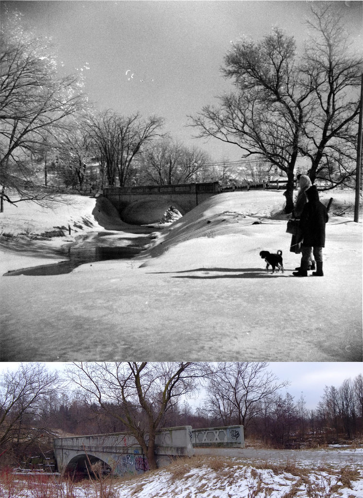
Comparison shot of the bridge, 1959 (by Ted Chirnside), and 2010 view by yours truly.

4323891792_76f4a655cb_b.jpg
 
Fascinating details, Marmaly. :) I didn't realize the bridge was still open to cars after about 1968, when the course of the road changed. That's news to me.

Thanks for the photos.

The bridge and the road remained open for some time after 1968. At least 4 or 5 more years - all the way to Leslie St. There was no reason to close it. The houses were still there and the bridge was structurally sound. The new Cummer Ave. took most of the traffic but I remember well asking my dad to use the old route whenever we passed that way. There was a certain appeal to the slow drive on the bumpy, narrow road and the idea of crossing the single lane bridge.

I recall that one of the first steps in the demise of Old Cummer was the closing of the section between Pineway Ave. and Leslie St. This was likely when construction of a small subdivision to the east began.

As a kid, I spent a lot of time in the ravine around the bridge and to the north of the new Cummer bridge where concrete abutments can be found - the remnants of an even older bridge crossing the Don River. We thought it was pretty cool at the time. It would be even cooler now!

And here's another anecdote. There is a white house on Beardmore - just north of Cummer - that blends into the subdivision due to several additions and renovations, but is actually over 150 years old. It was built by Jacob Cummer - the namesake of the street. Cummer Ave. was a sideroad that let to this house and the surrounding mill in the early to mid 1800s. I suspect that the heritage of the house has been lost over the years which would leave it open for demolition should the owner wish to do so.
 
I suppose another thing besides the subdivision that "sealed the deal" for Old Cummer was the level crossing--and at what point was a GO station here first planned?
 
Here's the 1947 aerial view of Old Cummer
OldCummer.jpg


It looks like the second driveway to the left before the southward bend in Old Cummer goes to the Jacob Cummer House.

There was another road going in from Leslie - maybe close to where 'new' Cummer is now - to Bruce Farm(?). The walking path up to Bestview appears to follow its route.

Yes, Anna that is it. Here is a cap
44 beardmore.jpg
from Google Street View.

Here's what I have found about the house: John Cummer, Jacob's son, lived at what is now 44 Beardmore Crescent which overlooked Jacob's Cummer Mill on the Don River. The house was originally a farm house built circa 1850 but was substantially renovated into its present structure circa 1933.
 

Attachments

  • 44 beardmore.jpg
    44 beardmore.jpg
    66 KB · Views: 1,088
I suppose another thing besides the subdivision that "sealed the deal" for Old Cummer was the level crossing--and at what point was a GO station here first planned?
Opened May 1, 1978, and I believe the community was first informed about it in '76. There was actually a street protest by the neighbourhood NIMBYs before it opened.

I think the level crossing was closed to vehicular traffic on Old Cummer sometime in '71, but certainly no later than '73.
 
I think the level crossing was closed to vehicular traffic on Old Cummer sometime in '71, but certainly no later than '73.[/QUOTE]

That sounds about right GenerationW. I was only 6 or 7 at the time, but I actually remember being disappointed when it closed because we had to use "New Cummer."
 

Back
Top