News   GLOBAL  |  Apr 02, 2020
 9.7K     0 
News   GLOBAL  |  Apr 01, 2020
 41K     0 
News   GLOBAL  |  Apr 01, 2020
 5.5K     0 

Why would the word "midtown" have any connotations about density? It's just geographic.

I don't agree. Does "downtown" only have a geographic connotation too?
Midtown IMO should have a certain level of density and vibrancy, a reduced downtown core. You can't call a pure residential area "midtown" as it would be the same as most of our suburbs.
 
I don't agree. Does "downtown" only have a geographic connotation too?
Midtown IMO should have a certain level of density and vibrancy, a reduced downtown core. You can't call a pure residential area "midtown" as it would be the same as most of our suburbs.

Um yeah, downtown in the North American context is usually the oldest part of the city, where the city originally spread out from. In Manhattan downtown means south, lower Manhattan, midtown & uptown are appropriately allocated going north to the Bronx.

Toronto same thing except going from south to north along Yonge, since Yonge is such an important street in our city. Bloor used to be uptown. Then Yonge & Eglinton became uptown and Bloor became midtown. After amalgamation with North York, it has been re-distributed again. That's what midtown means to me, that it's in roughly in the middle section of Yonge Street between Steeles and the Lake.
 
I don't know if it's been mentioned already. The bus bays are to be used as a staging area until the Eglinton LRT is done. In about a decade it is to become a public square.
 
The Yonge and Eg thread is too specific to that intersection and the nearby retail so how about a thread for the whole Midtown area of Toronto? Let's discuss the rapid growth and intensification of this lovely part of the city and communally yell at the downtowners for thinking we are some suburb :mad: and at the suburbanites for clogging the Yonge line by the time it arrives at Eglinton station! ;)

So what exactly are the boundaries of Midtown? Midtown is a comparatively newer re-branding as before amalgamation it was divided between the northern part of the old city of Toronto as well as parts of North York, York and East York as well. With amalgamation these borders were erased and now these areas find relevance with each other as Midtown and through economic centers along Yonge between St. Clair and Lawrence than with their old municipalities. Naturally this results in rather ambiguous borders. I myself consider Bayview to be the eastern border of Midtown, between it and Leaside. What are your thoughts?

...
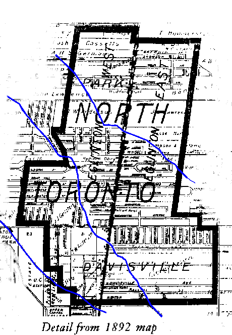
I actually took a class on Toronto's architecture and did my project on the history of what we're calling "midtown" now. There were three nodes of small villages at Davisville, Broadway/Montgomery and Lawrence Park. The Starbucks at Davisville is still the original building that was there back when that area was first settled, it was the store & post office of John Davis. The three towns formed a larger town called "North Toronto", and there was a streetcar line running down Yonge St. Eventually North Toronto joined Toronto since it needed better utilities & transit...

Why not say the borders are those of the old town of North Toronto. :D

North_Toronto.gif
 
I am curious to what the LRT does for Bayview-Eglinton. I think condo development at the intersection ala Y+E would be a bad move. What needs to be done to improve the area is connecting the Bayview-Eglinton intersection and the LRT subway station with the retail and commercial area south of Eglinton on Bayview. There is a row of houses (minus the church) along Bayview between Eglinton and Soudan that should be bought out and converted to low-rise condos with street level retail.

I agree Bayview & Eglinton has huge potential. You could totally see the Metro being re-developed (although I shop there now). There's an empty plot of land north of there which will be a Whole Foods, too bad that isn't going to be a residential development.

I think Bayview is an area that can stay away from highrises and the intensification we are seeing at Yonge and Eglinton. A few midrises here and there to add some more density to the area and connecting the intersection with the retail would already make the intersection a much more vibrant place.

The metro is fine as is, however the LRT station will take part of the parking lot.

The plans I've seen from the Eglinton Crosstown study show the main LRT station where McDonalds is, with the secondary entrance in the Metro parking lot. There is also this from the Eglinton Connects planning study showing possible redevelopment of the Metro site:
 

Attachments

  • bayview eg.jpg
    bayview eg.jpg
    99.6 KB · Views: 657
Why not say the borders are those of the old town of North Toronto. :D

Makes sense to me! :) Many neighbourhoods' boundaries are defined by where the original towns that made up Toronto were, like Yorkville & Forest Hill.
 
I wish there was a higher res version of that possible development image, I can't make out if its my building that is highlighted there or not! :p

I've spent a lot of time peering out my window imagining development of the intersection and I'll remain skeptical of Metro being developed into anything until some developer begins to make noise about it. There are better sites that will be looked at first.

And yes, it was my impression that the Mcdonalds building would be reclad and extended to include the ECLRT stop, with a secondary stop at Metro and potential for a third at the north-east corner where the plaza is located.

Here's the link to the full PDF from May. That was just the 'mid-rise' scenario, there is also a 'tall buildings' scenario.
http://www1.toronto.ca/staticfiles/...n_design/files/pdf/egconnects_focus_may13.pdf

from here
http://www1.toronto.ca/wps/portal/contentonly?vgnextoid=0f8e86664ea71410VgnVCM10000071d60f89RCRD

Both the Bayview & Laird sections looks great! I've been to a few public meetings, and I've been really impressed with the Eglinton Connects plans. I hope their recommendations do happen, it would be great to get big trees & bike lanes on Eglinton.
 
I like the Dufferin highrise, Don Mills and Laird scenarios. The Bayview midrise scenario looks good too, hopefully I move out before anything actually begins constructing though. :p

I don't know anything about the Golden Mile so I can't comment. What they propose is ambitious though.
 
What is Midtown

Makes sense to me! :) Many neighbourhoods' boundaries are defined by where the original towns that made up Toronto were, like Yorkville & Forest Hill.

Midtown in my view... is the distinctively different urban structure that arose with the advent of public transit tram lines. It resides between the historical city structure of the Downtown whose origins related to an earlier pedestrian era, and North York which evolved upon an automotive orientation. Laterally, Midtown pivots about Yonge Street - as do the Downtown and North York. Its far eastern extent is the impasse of the Don Valley, and its far western limit is less legible, but when you've crossed the line you know it. There is a narrower measure, and that is when one opts to drive.

The suggestion of snapping new boundary definitions to conform to old lines, whether jurisdictional or statutory, always makes me nervous. Were these earlier lines based upon astute resonances, or just the arbitrary determination in past ages? The determination of the Growth Centre at Yonge Eglinton is a good example of where 'snapping' to existing lines doesn't work. It opted to adopt an existing set of lines when confronted with the pesky question of what should be the extent of the intended intensification. This has harnessed this area with contentious transitions along its edges.
 
Hi Patrick, do you mind elaborating on a few things? What do you mean by "destabilization" and that "A whole section of this city is being destabilized."?

I don't really find our neighbourhood to be "open space-deficient" by which you seem to mean parks. I love Sherwood park, there were tons of kids tobogganing there this weekend, you can either go all the way to Yonge & Lawrence or the Don ravine from there. We've got the Don Valley ravine, Sunnybrook park, the belt-line trail (amazing), Cedarvale ravine, Eglinton Park, Mt Pleasant cemetery, all great for jogging or biking. I've also noticed a lot of smaller parks scattered throughout.

If we're deficient in something I'd say we're "indie-cafe-deficient" and "ramen-deficient" :). I would've said that we're sushi-deficient, but I discovered Lola which is pretty good.

A population of 23,000 equates to the same size as the 100th largest city in Canada. Over the next 15 years, 23,000 new residents will live in an area one kilometer in diameter at Yonge and Eglinton. City of Toronto Planning Department has done no future-focused planning for it. As examples of the danger we are in; the City is demanding huge spaces to be made available for bicycles at the 25 or so towers already built, approved or in the assessment stream. How all of those thousands and thousands of bikers will be accommodated within a public realm that is fixed is something I don't believe our planners can now solve . Add to this the expected influx of pet dogs. Where will they go to be walked and have a pee? Children coming to the area will not be able to walk to school, they will be bussed out of the area. Hardly good planning, eh? More like destabilization, I would say.

No matter our own personal experiences, according to the City Planning calculations the area has been open space-deficient since 1967. According to the OP, the area falls within its lowest parkland quintile of less than 0.46 hectares/1,000 population. Apart from that, the sidewalks in the area are skimpy, being unchanged from decades ago when they were first created. With the approval of the North York Community Planning Department, we've lost the open space at the NW corner of YE. By its own admission, the Toronto Planning Department "is not very good at public realm stuff". Hardly good planning, eh?

We're in trouble.

BTW, I understand that the YE area is considered one of the most intense areas for restaurants and eateries in all of North America.
 
I like the Dufferin highrise, Don Mills and Laird scenarios. The Bayview midrise scenario looks good too, hopefully I move out before anything actually begins constructing though. :p

I don't know anything about the Golden Mile so I can't comment. What they propose is ambitious though.

Are you worried about your view being blocked? Or construction noise? :)
It's tough to avoid construction in Toronto for obvious reasons. When I moved out of a Bay St condo, there were several towers growing around it, ready to block the views. Part of living in this city is watching towers grow over the years.

"We're tearing down hoods building condos, we're cutting down woods building condos, welcome to Toronto, such a diverse combo" - Toronto rapper Rich Kidd - The City

Re Patrick:
I agree this area has some great restaurants, although it skews heavily towards Italian (which is great). I haven't found a good ramen place though, which I'm used to from living on Bay St. Does anybody have any recommendations?

In terms of coffee, I'd like to see more independents or Toronto based coffee places like Balzac's, and less Starbucks, 2nd Cup's, and Timothy's. So far there's Rachel's, De Mello Palhetta, a there are a couple of good ones near Lawrence. I think the condo growth in the area will help create demand for more interesting cafe's.
 
Good planning isn't about ensuring there is a noodle shop in your neighbourhood, but I do notice it's things like that the downtown elites get all hung-up about.

Are you sure, ehlow, that you're in the right forum?
 
Good planning isn't about ensuring there is a noodle shop in your neighbourhood, but I do notice it's things like that the downtown elites get all hung-up about.

Are you sure, ehlow, that you're in the right forum?

I never claimed that good planning was about that.. ha ha. I was under the impression we could discuss things like food in our neighbourhood in this thread. It seems appropriate to me.

Thanks for creating this thread. Now I have a place to complain about lack of coffee choices and local issues without disrupting threads!
 

Back
Top