News   GLOBAL  |  Apr 02, 2020
 9.7K     0 
News   GLOBAL  |  Apr 01, 2020
 41K     0 
News   GLOBAL  |  Apr 01, 2020
 5.5K     0 

The tracks are poking out through the asphalt in your photo were deceptive in terms of recreating the location; perhaps a similar building was located on Princess. Nonetheless, the 1927 is interesting for other reasons. If the tracks in the 1927 photo are train tracks, it would be a rare instance of heavy rail street running in Toronto. I've only found evidence for it happening on Basin and Sudbury Streets in Toronto. Yet note the overhead wires across the street. They might have been streetcar tracks. If they were streetcar tracks, it's possible that freight was being moved with the streetcar network, something I wouldn't mind seeing today. Alternately, the warehouse produced goods for servicing the streetcar network. It's a curiosity.

These were streetcar tracks The building at the SE corner of Front and Frederick (now the Theatre for Young People) used to be a TTC (or Toronto Street Railway) building and still belongs to the City. It was used as a powerhouse and I think the TTC owned other buildings further south on Frederick. The TTC also owned the site on north side of Front Street (where Greyhouind now is); this siqe was recently sold and a 34 (really) floor building is proposed. There are quite a few "then" photos (including this one) of this area on a condo building site (www.mtcc573.ca)
 
Last edited:
These were streetcar tracks The building at the SE corner of Front and Frederick (now the Theatre for Young People) used to be a TTC (or Toronto Street Railway) building and still belongs to the City. It was used as a powerhouse and I think the TTC owned other buildings further south on Frederick. The TTC also owned the site on north side of Front Street (where Greyhouind now is); this siqe was recently sold and a 34 (really) floor building is proposed. There are quite a few "then" photos (including this one) of this area on a condo building site (www.mtcc573.ca)
Street cars,
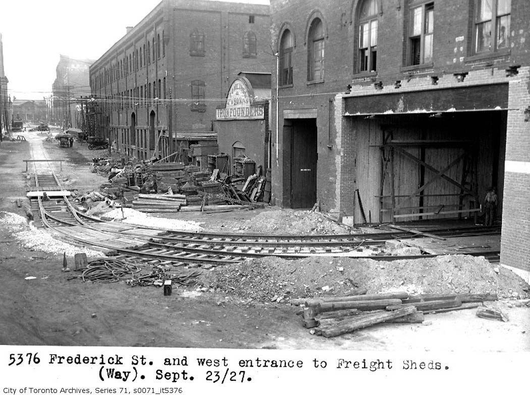
Yes, and if you look at the bottom of the "new" steel beam in the recently enlarged doorway, you will see the two cleats holding trolley wires as they pass into the building. Also fits with the iron founders next door, axles and wheels maybe?
My father's house was on the south side of the Windmill line co-op, just to the south east of here. Apparently it was pretty heavy and toxic industry in it's day. I remember something about removing carbon black prior to the building of Market Lane Public school and the rest of that in fill on the north side of The esplanade, east of Princess. And the houses down there are all built on structural slabs and have methane test pipes running into the attics.
 
From the looks of it, that corner is pretty tight for a rail car. My first guess would be streetcar tracks.
 
Toronto Railway Co. Motor Shops

First post here, been enjoying this thread immensely for the past year or so. Kudos to all and especially Mustapha for taking the time to line up the Now photos to the Then photos to get the discussions flowing. I've found them very informative and the posters' recollections bring a good sense of humanity to the subjects.

According to an Upper Canada Railway Society 1971 walking tour handout, the building in the photo was originally the Toronto Railway Company Motor Shops bulding (first section built in 1892), for repair of streetcar motors and the Stores Dept. It gradually expanded and was replaced by the new Hillcrest Shops in 1924 by the TTC. It was then used for storage, and in 1927 was re-opened as a Freight and Express Terminal for for the Toronto & York Metropolitan Division (the Lake Simcoe line), on which the TTC did have some light freight traffic. In 1930 it was turned into a bus garage, which it remained as until it closed in 1980 (then known as the Sherbourne Garage). It was used for TTC buses until 1966, and then by Gray Coach Lines until 1980 when Gray Coach moved to Commissioners St (now the Wheel-Trans garage). It was demolished not long after that.
 
Last edited:
First post here..
According to an Upper Canada Railway Society 1971 walking tour handout, the building in the photo was originally the Toronto Railway Company Motor Shops bulding (first section built in 1892), for repair of streetcar motors and the Stores Dept. It gradually expanded and was replaced by the new Hillcrest Shops in 1924 by the TTC. It was then used for storage, and in 1927 was re-opened as a Freight and Express Terminal for for the Toronto & York Metropolitan Division (the Lake Simcoe line), on which the TTC did have some light freight traffic. In 1930 it was turned into a bus garage, which it remained as until it closed in 1980 (then known as the Sherbourne Garage). It was used for TTC buses until 1966, and then by Gray Coach Lines until 1980 when Gray Coach moved to Commissioners St (now the Wheel-Trans garage). It was demolished not long after that.

First: Welcome and yes we all owe Mustapha a great debt for starting and maintaining this thread!
Second. I think you mean that the building on the North side of Front Street, where the Greyhound depot now is (not in Then photo) , was the Sherbourne Garage and that this was demolished. Clearly the Theatre for Young People on south side of Front Street (the building in the Then photo) was not demolished.

The Toronto Archives site has a photo of the Sherbourne Bus Garage at https://gencat4.eloquent-systems.com/webcat/systems/toronto.arch/resource/ser71/s0071_it5611.jpg I am unclear if this is the Front or the Sherbourne side, but probably the Sherbourne I think.
 
Last edited:
July 20 Then and Now.


Then. "Sep 23, 1927. Frederick St. and west entrance to Freight Sheds."

Someone went to some expense to convert a warehouse into a train accessible building. Note the freshly modified doorway. I wonder what kind of business went on here?

io.jpg

Got it.

What we're looking at is the west side of the TTC's Sherbourne St Freight Shed.

In 1927, the TTC took over the Metropolitan Railway, which used to run from the CPR North Toronto (later cut back to Glen Echo) all the way to Lake Simcoe along Yonge St. At first the line was run as a separate railway becuase of the difference in track gauge, but in September the entire line was re-gauged to TTC gauge.

The Metropolitan line also ran a small freight service, which the TTC continued. From the Upper Canada Railway Society Newsletter, March/April 1973:

"The old Sherbourne St St. Shops building (used as a warehouse after March 1924) was converted to a freight and express office. On November 1, 1927, radial history was made as the first Lake Simcoe Line express car was despatched from dowtown Toronto. The routing chosen for the express cars was west on Front to Church, north to Carlton, west to Yonge, and nort on Yonge to the City Limits and points north."

This was shortlived, as declining revenue becasue of increased competition from trucks and cars along with old equipment resulted in the abandonment of service north of Glen Echo on March 16, 1930. The line between Glen Echo and Richmond Hill was bought by the local municipalities, and service run by the TTC began again on July 17.

EDIT: Dang, too slow!
 
I think we have not quite got it yet. We are looking at the west side of the The Theatre for Young people Building (on south side of Front Street). It is Designated and is described in the listing as:

Toronto Street Railway Stables, 1887-88, H.G. Salisbury, (now known as the Young People's Theatre) -adopted by City Council on June 20, 1973 DESIGNATION BY-LAW PASSED BY CITY COUNCIL on March 17, 1976. That is the more elegant building, the Freight Sheds were apparently to the south of it and may have extended over to Sherbourne Street.

I think that there was a Sherbourne Street Freight Building on north side of Front Street (where the Greyhound now is) - there is a photo of it at https://gencat4.eloquent-systems.com/webcat/systems/toronto.arch/resource/ser71/s0071_it5375.jpg I am not clear whether the photo is south or north of Front Street, if south it looks as though the track went in at the east side of the building on Frederick - as seen in the original photo - and came out on the west side at Lower Sherbourne - as shown on this link. Maybe someone with access to a 1920s map can confirm?
 
Last edited:
I think we have not quite got it yet. We are looking at the west side of the The Theatre for Young people Building (on south side of Front Street). It is Designated and is described in the listing as:

Toronto Street Railway Stables, 1887-88, H.G. Salisbury, (now known as the Young People's Theatre) -adopted by City Council on June 20, 1973 DESIGNATION BY-LAW PASSED BY CITY COUNCIL on March 17, 1976. That is the more elegant building, the Freight Sheds were apparently to the south of it and may have extended over to Sherbourne Street.

I think that there was a Sherbourne Street Freight Building on north side of Front Street (where the Greyhound now is) - there is a photo of it at https://gencat4.eloquent-systems.com/webcat/systems/toronto.arch/resource/ser71/s0071_it5375.jpg I am not clear whether the photo is south or north of Front Street, if south it looks as though the track went in at the east side of the building on Frederick - as seen in the original photo - and came out on the west side at Lower Sherbourne - as shown on this link. Maybe someone with access to a 1920s map can confirm?

The frieght building, seen in the shots with the tracks entering the west side of the building on Fredrick and travelling through to the east side of the building on Sherbourne. It is south of the young peoples theatre. This shot, Is the Sherbourne side looking north.
s0071_it5375.jpg

This shot is the sherbourne, after the renos, side looking south.
s0071_it5611.jpg

Fredrick is west of sherbourne, the now shot Mustapha took was actually Princess street, east of Sherboourne.
 
We are looking at the west side of YPT, but the building has been changed since the days of the Toronto Railway Company.

Count the number of windows, then check this Google maps image.

The south half of the building has been torn down. This building used to extend halfway down the block. The 'then' photo that Mustafa showed us is actually taken at Frederick and Espanade, looking north on Frederick. The freight shed fronted onto Sherbourne, but ran the width of the block on the north side of Espanade. The photo you referenced is taken at Sherbourne & Esplanade, looking north on Sherbourne.

Here's the 1924 Goad's fire insurance map of the area. (requires mrSID plugin to work) YPT is the north half of the building on the SE corner of Front & Frederick. The freight shed is the large building along the Esplanade, between Sherbourne & Frederick
 
Wish I could open that Goad's map, can't seem to find a plug in for Firefox yet.
It just seems that the iron foundry in the first then shot separates the YPT building from the Frieght building.
And yes, the YPT building does appear to have been shortened.
 
"it would be a rare instance of heavy rail street running in Toronto." QUOTE junctionist.


Liberty Street, Mowat Ave, Pardee Avenue, Jefferson Ave, Hanna Avenue - lower crossing, Liberty St East, Eighth? Street - New Toronto,

just to name a few "rail roads".


"it's possible that freight was being moved with the streetcar network,' QUOTE junctionist.

Differing guage; not possible.


Regards,
J T

That heavy rail street running happened on all those streets is fascinating. It's something that really speaks of the extensive industrial heritage of the city and the rail dependence of industry back then. Are you sure that it was true street running on all those streets, as opposed to crossings or the rails in their own right of way along the side of the road? Google street view imagery on Mowat, for instance, only shows remnants of tracks crossing the street and then perhaps running along the side of it. Also, do you have any more info or a collection of photos on the topic by any chance?

By moving freight with the streetcar network, I meant using vehicles like streetcars adapted for moving light freight. With a much more extensive network back then and diverse industry and merchants in different places, I assume that it would have been practical for some purposes. As a couple of people have noted, the Toronto and York Metropolitan Division did move light freight, and perhaps it was done elsewhere in the light rail networks of the city.
 
I think that there was a Sherbourne Street Freight Building on north side of Front Street (where the Greyhound now is) QUOTE]

The UCRS handout notes that the north-west corner of Front & Sherbourne where Greyhound is located was a small car yard, with a carpenter's shop to the west on the north side of Front and a "storage/battery building" at the north-east corner of Front & Frederick.

A small remnant of track is actually visible on Frederick today - a curve coming out of the Gray Coach/Greyhound Bus Parcel Express terminal.

Regards,
 

Back
Top