News   GLOBAL  |  Apr 02, 2020
 9.8K     0 
News   GLOBAL  |  Apr 01, 2020
 41K     0 
News   GLOBAL  |  Apr 01, 2020
 5.6K     0 

Most fascinating. The SS recruiting office on Dam Square... there's a bakery/coffeeshop there now - many cuppas there when I travelled for work. The street to the left is the famous Kalverstraat.. then and now still Amsterdam's main downtown promenade.

The Kalverstraat is actually on the other side of the square (behind the photographer). The street we are looking down here is Nieuwendijk - not as famous as the Kalverstraat, but just as commercial and also a pedestrian zone.
 
Hello again, my friends...

Thanks for the suggestion about contacting the Toronto Police, Mustapha. Unfortunately, because no public money has been made available the museum is chronically underfunded and understaffed. I do have a connection with the Toronto Police, I served from 1973 to 2007 ! I can recall a few years ago, while I was still on active service, I wanted to get the service record of an officer who was sworn in in 1890 and retired in 1927; the Police Museum wanted to charge me a research fee ! I sent the "2 Division" photo to them via e-mail anyway, this morning. So far, it looks as though none of their resources are digitized (if I still lived in Toronto, I might have considered volunteering one day a week just to do that).

Today's submission from my collection is from 1931, Stanley barracks. The only surviving building is the Officers' Quarters, used to house the Marine Museum from 1959 to 1998. I have no idea what it's used for now. My photo is 26" x 6 3/4" and must have at one time been part of a set of two. I only have the one image, but this is an excellent example of all I like about these old panoramic photos: the detail is fantastic; each person's face could be a portrait. From my limited experience with uploading photos to this forum, I will have to reduce the image size (as scanned and spliced, my image is 5.04MB, 7648x2067 pixels.

RCD Toronto 1931 50.jpg


Yeah, I had to reduce it to 50%. Enjoy, all !
 

Attachments

  • RCD Toronto 1931 50.jpg
    RCD Toronto 1931 50.jpg
    107 KB · Views: 1,500
Where are all the old police stations before the modern Metro Police divisions were created?

I'm aware of a few that survive to this day.

Number 6 - 1313 Queen St West, Parkdale (now a gallery)
Number 7 - 756 Ossington Avenue (just north of Bloor, now a daycare)
Number 10 - 97 Main Street (now a community centre)
Number 12 - 2398 Yonge Street, north of Eglinton (now the Anne Johnston Health Station)
Number 13 - 674 Markham Street (Now an EMS station)

Can some help fill in the gaps? I guess we have Station #2 accounted for.
Number 9 was on Keele south of Dundas next to the fire station, long demolished.
 
Last edited:
My, but it's been a busy past 24 hours on this thread.

No rest for us wicked. :)


Here is the Then and Now for October 10, 2012.


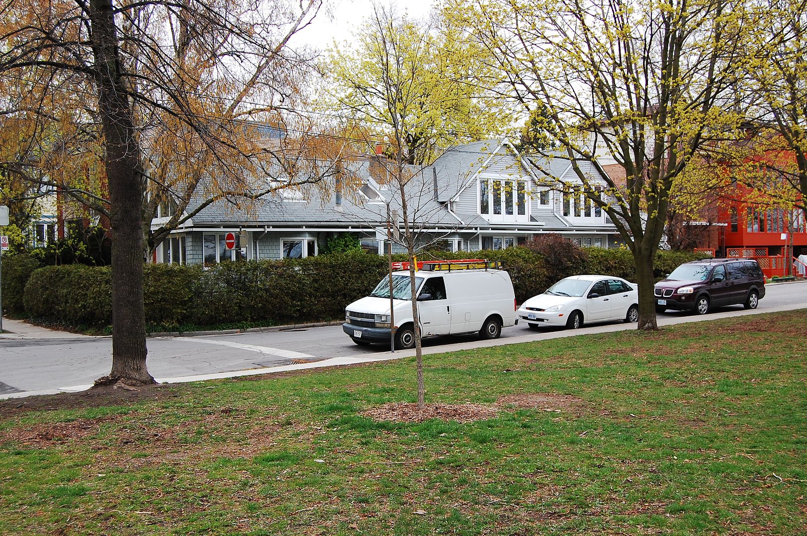
Then. Beach, E of McLean Ave. Dec 5, 1917.

809.jpg


Now. May 2012.

810.jpg

If I'm not mistaken, the new homes (and street) were built further back from the lakeshore than the originals.
I don't think there was any landfill created here.
 
I've since been able to expand the list and partially answered my old question. Bolded names mean the building is partially or wholly still standing.

Number 1 - 149 College Street. Former Toronto Police Headquarters 1931-1957, though built as the Toronto Athletic Club, now part of Rotman.
Number 2 - Bay Street near Dundas, demolished
Number 3 - Claremont St, north of Queen, demolished, now a modern fire hall
Number 4 - Dundas St E, East of Parliament, demolished for Regent Park in 1950s
Number 5 - 135 Davenport Road (Now an EMS station)
Number 6 - 1313 Queen St West, Parkdale (now a gallery)
Number 7 - 756 Ossington Avenue (just north of Bloor, now a daycare)
Number 9 - Keele south of Dundas, demolished
Number 10 - 97 Main Street (now a community centre)
Number 12 - 2398 Yonge Street, north of Eglinton (now the Anne Johnston Health Station)
Number 13 - 674 Markham Street (Now an EMS station)

Still missing 8 and 11. 11 was the "Hillcrest" station, but unable to locate the building or site.
 
Last edited:
I've since been able to expand the list and partially answered my old question. Bolded names mean the building is partially or wholly still standing.

Still missing 8 and 11. 11 was the "Hillcrest" station, but unable to locate the building or site.

There's also 126 Pape Avenue, which has been repurposed multiple times since its days as a police station. I am not sure what number it was.
 
That might be Station 8. Interesting that it, like 5 and 13, it is now an EMS station. Thanks. 126 Pape continued in the Metro era for a bit as 56 Division, before combining with 55 Division (at the old Main St Station #10) to a new 55 at Coxwell and Dundas in the 1970s.
 
Last edited:
Today's submission from my collection is from 1931, Stanley barracks. The only surviving building is the Officers' Quarters, used to house the Marine Museum from 1959 to 1998. I have no idea what it's used for now. My photo is 26" x 6 3/4" and must have at one time been part of a set of two. I only have the one image, but this is an excellent example of all I like about these old panoramic photos: the detail is fantastic; each person's face could be a portrait. From my limited experience with uploading photos to this forum, I will have to reduce the image size (as scanned and spliced, my image is 5.04MB, 7648x2067 pixels.

View attachment 9443

Yeah, I had to reduce it to 50%. Enjoy, all !

Interesting photo! Normally this wouldn't have caught my attention, however it stood out as I was at the Heritage Toronto Awards last night where a book specifically dedicated to the history of Stanley Barracks won an award. If interested the book is called Stanley Barracks: Toronto's Military Legacy by A. Sendzikas.
 
I'd love to have all the answers, but you have a more complete list than I do. I was a rookie in 1973, sixteen years after amalgamation. It was all I could do to find my way to our neighbouring stations. I remember one afternoon in the mid 70's, my partner and I, working out of 12 Division at Keele and Eglinton, took a female prisoner to Headquarters at 590 Jarvis Street to be fingerprinted. After we got back into the car we realized that neither of us knew how to get to 55 Division (where all female prisoners were held overnight at that time). We asked a passing officer for directions; when we realized that he was a Staff Sergeant, we didn't need the red roof lights - the car was lit up red on the inside from our faces !
 
Last edited:
If I'm not mistaken, the new homes (and street) were built further back from the lakeshore than the originals.
I don't think there was any landfill created here.

Thanks Goldie, this means that the Then picture is now park space; and these houses were situated where the boardwalk is now.
 
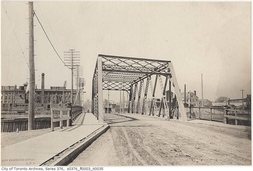
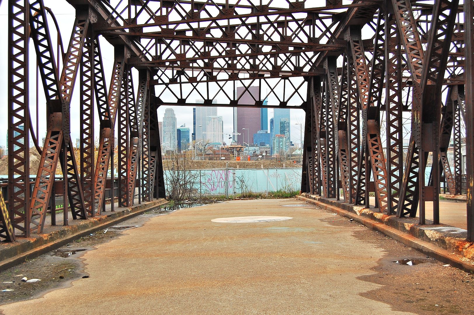
Then and Now for October 11, 2012.


Then. Eastern Avenue Bridge. 1900-ish I'm guessing. Looking W; I believe. The spot where the photographer is standing is now - best guess - the southbound lanes of the Don Valley Parkway.

811.jpg


Now. May 2012. Bridge To Nowhere. This bridge is rusty and looks similar to the Then picture, but this structure dates from 1933. The original bridge was destroyed by ice. The Don Valley Parkway put an end to the usefulness of this bridge by bypassing it in in 1964, so it's been marooned since.

812.jpg


Some of you may recognize the Now picture from previous use here at UT. I posted it awhile back in Goldie's photography thread. The bridge is worth a visit if you have nothing else to do. Enter the bike/walking path from the south side of the Queen Street bridge and walk a few hundred yards south, the gap in the fence may still be there.


http://en.wikipedia.org/wiki/Old_Eastern_Avenue_Bridge
 
I've since been able to expand the list and partially answered my old question. Bolded names mean the building is partially or wholly still standing.

Number 1 - 149 College Street. Former Toronto Police Headquarters 1931-1957, though built as the Toronto Athletic Club, now part of Rotman.
Number 2 - Bay Street near Dundas, demolished
Number 3 - Claremont St, north of Queen, demolished, now a modern fire hall
Number 4 - Dundas St E, East of Parliament, demolished for Regent Park in 1950s
Number 5 - 135 Davenport Road (Now an EMS station)
Number 6 - 1313 Queen St West, Parkdale (now a gallery)
Number 7 - 756 Ossington Avenue (just north of Bloor, now a daycare)
Number 9 - Keele south of Dundas, demolished
Number 10 - 97 Main Street (now a community centre)
Number 12 - 2398 Yonge Street, north of Eglinton (now the Anne Johnston Health Station)
Number 13 - 674 Markham Street (Now an EMS station)

Still missing 8 and 11. 11 was the "Hillcrest" station, but unable to locate the building or site.

What time period are you looking at? From City Directories

1912:
Headquarters were at City Hall
Number 1 - 8-10 Court Street (with the mounted police at 6 Court)
Number 2 - 59 Agnes (Dundas W)
Number 3 - 501 Richmond W
Number 4 - 246 Wilton (Dundas E)
Number 5 - 860 Yonge
Number 6 - 1313 Queen St West
Number 7 - 500 Ossington Avenue (same location, different number?)
Number 8 - 130 Pape Ave
Number 9 - 902 Keele
Number 10 - 178 Main Street

1922:
Headquarters were at City Hall
Number 1 - 8-10 Court Street
Number 2 - 75 Dundas W
Number 3 - 31 Claremont
Number 4 - 466 Dundas E
Number 5 - 135 Davenport - with mounted police (substation 2398 Yonge)
Number 6 - 1313 Queen St West
Number 7 - 756 Ossington Avenue
Number 8 - 126 Pape Ave
Number 9 - 902 Keele
Number 10 - 97 Main Street
Number 11 - corner London & Markham (674 Markham now an EMS station)
 
Last edited:

Back
Top