News   GLOBAL  |  Apr 02, 2020
 8.6K     0 
News   GLOBAL  |  Apr 01, 2020
 39K     0 
News   GLOBAL  |  Apr 01, 2020
 4.8K     0 

'Shoppers' replaces 'Loblaws' and the old house with front porch is gone - replaced by a CIBC "Banking Centre."

TN1012Pape1948-13_zpsa126e4c6.jpg
 
Another creative and very well done [so well done in fact one of the best of this genre I've come across] Then and Now of the New York City area:

http://www.nyc-grid.com/home/tag/before-after


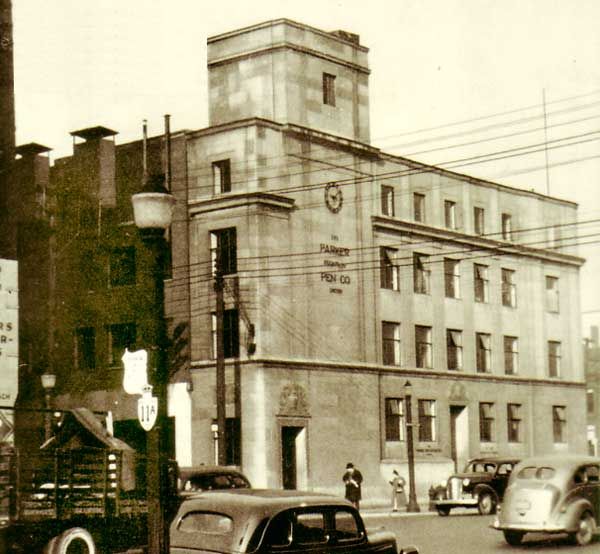
Then. 1935-ish, I'm guessing. Parker Pen Company. NW corner of University and Pearl. Parker moved here in 1932-ish.
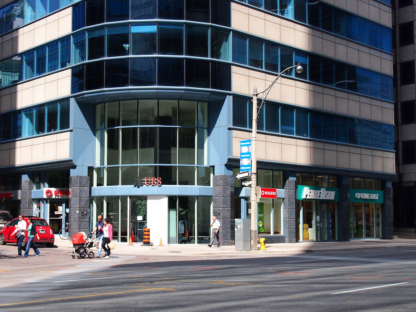
1207154university_zps49f18eb1.jpg


Now. July 2013.

1208_zps251fd735.jpg


"By 1932 Duofold pens were being manufactured in Toronto and anticipating a success of the upcoming Vacumatic Parker decided that the space on Sorauren Avenue was too small. Parker bought and moved the production to a plant on 154-158 University Avenue. In time the factory in Canada would be shipping to 70 countries all over the world.


http://www.parkerpens.net/televisor.html

I would just like to note the synchronicity (or just dumb coincidence) of there being a Pearle Vision outlet at the corner of Pearl Street.
 
EUREKA!
After considerable searching, here's a copy of my 1982 Kodachrome of a PCC relic that was in a field at the N/W corner of Warden and Steeles (Markham).

Also found this related Web page: http://transit.toronto.on.ca/streetcar/4006.shtml

PCCstreetcarinMarkham1982x_zpscebc967e.jpg

A wonderful Kodachrome, Goldie. That NW corner doesn't remotely look like that now. There is now a nice Asian supermarket - 'T&T' - about 300 yards N of where that streetcar was.

About a 1/2 mile north of here, just S of Denison on the E side of Warden is St. John's 5th Line Church Cemetery, a well maintained [by Markham municipality] pioneer cemetery.
 
my sincere apologies if this link has been posted before (i searched, but did not find) --

Series 12, 1983 Aerial photographs of the Metropolitan Toronto Area

these are interactive maps, zoomable, and there's over a hunnert of them!!

i hope these may be useful in your collective "then and now" explorations...

And here's another possibly useful and interesting link that was posted here ages ago.

A Flickr album. The Toronto Archives maintains it.

Old, and older, pictures of our City thrown into a Flickr album with no apparent organization - and all the more charming for the perusal.

Like flipping through an old Life Magazine. Ok; like an old Maclean's then. No, definitely make that a Life magazine, Macleans was never known as a photo journalistic heavyweight. My opinion of course..

http://www.flickr.com/photos/torontohistory/
 
Given the buildings in the background, it'd be more likely late 80s--esp. if it looks like the Spadina bridge is in mid-rebuilding (are those new railings on the left?)
 
Given the buildings in the background, it'd be more likely late 80s--esp. if it looks like the Spadina bridge is in mid-rebuilding (are those new railings on the left?)

I'd go with 1988 or early 1989 - note the brand new TTC bus stop sign that shows a more generic bus icon (instead of the iconic GM New Look).
 
One of the best decisions in the evolution of the Railway Lands was to bring all the land flanking Spadina up to the grade of what was then a bridge, as opposed to leaving "grade" down at the level of the railway tracks, thereby normalizing (to some extent) the pedestrian experience.

The original bridge under construction in 1927:

s0372_ss0079_it02001.jpg


And complete:

s0071_it4903.jpg


How Spadina met the lake, 1892:


1907:

980-30-2.jpg
 

Attachments

  • s0372_ss0079_it02001.jpg
    s0372_ss0079_it02001.jpg
    77.7 KB · Views: 786
  • s0071_it4903.jpg
    s0071_it4903.jpg
    101.8 KB · Views: 754
  • 980-30-2.jpg
    980-30-2.jpg
    92.5 KB · Views: 763
Last edited:
One of the best decisions in the evolution of the Railway Lands was to bring all the land flanking Spadina up to the grade of what was then a bridge, as opposed to leaving "grade" down at the level of the railway tracks, thereby normalizing (to some extent) the pedestrian experience.

The map is interesting in that it shows The Esplanade running as far west as Spadina (though it looks more like rail tracks to me!). Of course The Esplanade was originally the main part of the Walks and Gardens and everything west of Yonge was sold off. The section east of Yonge was primarily rail yards until the 1970
s
esplanadearberkeleyold.jpg
 

Attachments

  • esplanadearberkeleyold.jpg
    esplanadearberkeleyold.jpg
    94.2 KB · Views: 884
The map is interesting in that it shows The Esplanade running as far west as Spadina (though it looks more like rail tracks to me!). Of course The Esplanade was originally the main part of the Walks and Gardens and everything west of Yonge was sold off. The section east of Yonge was primarily rail yards until the 1970
s View attachment 19551

Interesting map from 1884:


A proposal from 1853 would have seen the railroads covered:


Last edited:
Given the buildings in the background, it'd be more likely late 80s--esp. if it looks like the Spadina bridge is in mid-rebuilding (are those new railings on the left?)

The photo can't be any earlier than February 1987 as that's when the "Blue Night Network" night bus routes were introduced. This was when the blue decals were added to the stops with 24-hour service.
 

Back
Top