News   GLOBAL  |  Apr 02, 2020
 8.4K     0 
News   GLOBAL  |  Apr 01, 2020
 39K     0 
News   GLOBAL  |  Apr 01, 2020
 4.7K     0 

The area around the church could really use a facelift like St James park just south of there. Beautiful building with much needed greenery in the core, but in such a terrible state. I'm guessing the parking lot is a good source of income for them though.
There is a thread you might want to look at - though nothing has happened for years! https://urbantoronto.ca/forum/threads/toronto-the-metropolitan-113-99m-37s-lancer-developments.714/

The park around the Church does NOT belong to the City so fixing it up (which would be great) would be a Church project. (The area of St James Park east of the Church belongs to the City, the area west of it to the Church - which is why only the east side was fixed up a couple of years ago.)
Not sure where the S.37 money was allocated from the 60 and 88 Queen projects but revitalizing the green space around the Metropolitan would have been nice.
 
True but s 37 funds cannot be spent on non-city things and the land belongs to the Church.
They actually can. $1.0M in cash was given to Massey Hall by MOD Developments (in addition to the land donation) as part of the Massey Tower development and secured in the S.37 agreement. All it takes is some creative thinking by those involved (including the planners and Councillor).
 
They actually can. $1.0M in cash was given to Massey Hall by MOD Developments (in addition to the land donation) as part of the Massey Tower development and secured in the S.37 agreement. All it takes is some creative thinking by those involved (including the planners and Councillor).
That is true (and also happened with the lighting of St James where part of the cost came from s37 funds) but it does take more effort than many Councillors are prepared to make and is not routine.
 
The FB group 'Old Toronto Series'


posted pics of 'Sam the Record Man' from back in a day. Interesting to me to see it back before the way I remember it.

1672326086605.png


Not sure what year that is, but I grew up remembering it like this:

1672326197215.png

From: https://scontent.fyzd1-2.fna.fbcdn....7z9r1WLje63qhPdRZbI19U7OG5RtVCrQw&oe=63D512B1

***

The now:

1672326309134.png


Apologies to Snohetta and Ryerson/TMU, but I'm not sold on this as an improvement.
 
The FB group 'Old Toronto Series'


posted pics of 'Sam the Record Man' from back in a day. Interesting to me to see it back before the way I remember it.

View attachment 447561

Not sure what year that is, but I grew up remembering it like this:

View attachment 447562
From: https://scontent.fyzd1-2.fna.fbcdn....7z9r1WLje63qhPdRZbI19U7OG5RtVCrQw&oe=63D512B1

***

The now:

View attachment 447563

Apologies to Snohetta and Ryerson/TMU, but I'm not sold on this as an improvement.

Now I feel old. I remember shopping there in my teens.
 
The Facebook Group Transit Timewarp did a comparison of Kennedy Station, platform level, from its opening in 1980 to 2022.

The progression of its condition has not been kind:

1672508515736.png


- Ceiling over track removed
- Trackside finish partially replaced with non-matching colour
- Re-tiled the double column support with non-matching tile
- Some ceiling slats missing over the platform.

Ugh.
 
This is a relatively short, unsexy, then and now.
July 4th, 2021
1672668233065.jpeg


October 31, 2021
1672668293689.jpeg


December 29th 2022
1672668345712.jpeg
 
1619128523-20210422-lost-pond-toronto-3.jpg

From link. Note that it was Indian Road, not Keele Street (later Parkside Drive), that crossed the two-track level railway crossing to connect with Lake Shore Road (not Blvd.). Also note that "Sacred Heart Orphanage" became "St. Joseph's Hospital".

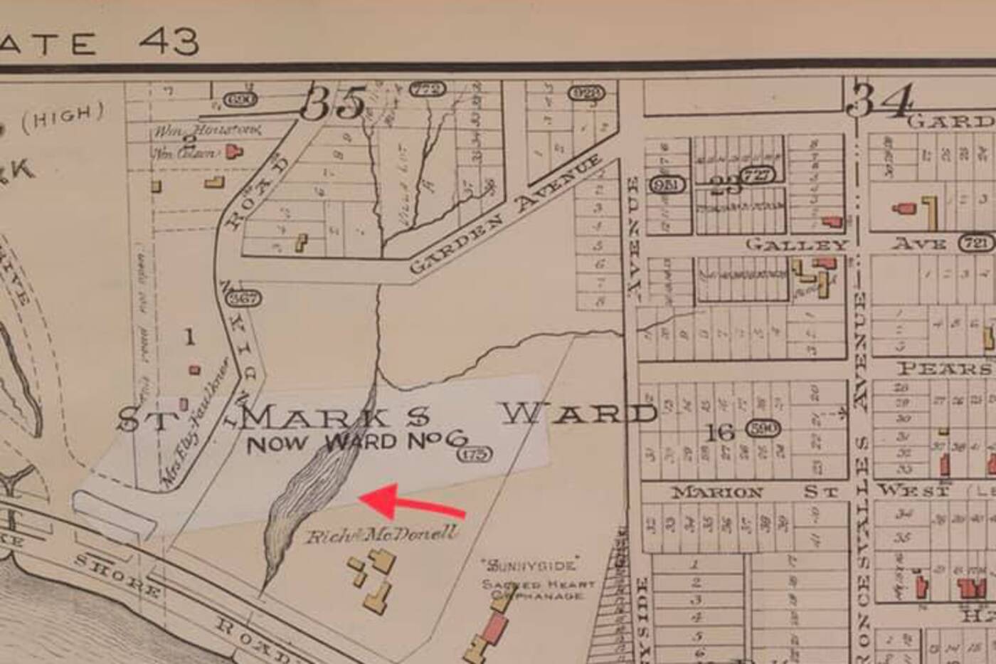
A small body of water on an old map in an area of Toronto that is now settled with homes caught the attention of a history buff.

There are plenty of lost rivers and creeks in Toronto, such as Garrison Creek or Mud Creek, which still run under the city but have been buried over time. Lost Rivers documents these water bodies on their website.

There is also the ancient Laurentian River that runs underground from Wasaga Beach and through High Park.

A round mark that looks like a pond between Parkside Drive and Indian Road near St. Joseph's Hospital, interested Walter Derzko who posted the find on the Bloor West High Park Junction community Facebook group.

Derzko told blogTO he started looking at old maps because he heard there were small creeks around Garden Avenue and Galley Avenue.

He found a map of Parkdale dated 1894 on the online University of Toronto Map and Data Library site.

"The Parkdale map clearly shows a pond," Derzko says.

There are several creeks that crossed through High Park and what is now a residential area, according to High Park Nature.


An 1884 reference shows the curve of a stream reaching just east of Parkside Drive and then curving back southeast towards the present-day intersection of Howard Park Avenue and Indian Road. By 1890, the creek is gone.

The names of these creeks are lost, and all were filled in or buried to make way for residential development.
1619129069-20210421-lost-pond-toronto-4.jpg

The homes at Sunnyside Avenue and Parkdale Road were beside an old pond. Google Maps photo.
It is interesting to note that sinkholes appeared on Parkside Drive in 2009 in the same place as one of these buried creeks, High Park Nature notes.

Since Derzko posted his find, he gathered more maps and residents have come forward with stories about flooded basements and tilted homes in the area.

"Before the city redid the water and sewer pipes under the road, Westminster would be like a river, with water flowing down, then down Indian Road... many flooded basements!!" one person wrote. "Two houses next to ours especially always had water in the basement."

"I wonder if that has anything to do with causing some of the houses in that area to be tilted, as if they were sinking into the ground," another person said.

It is difficult to know how large the pond was and how much is impacting the current infrastructure. Hopefully, there will be no more sinkholes and the residents can rest easy.
 
Last edited:
This is a relatively short, unsexy, then and now.
July 4th, 2021
View attachment 448126

October 31, 2021
View attachment 448127

December 29th 2022
View attachment 448128
Great photos of expanded use of an existing and formerly underutilized (by todays standards) brownfield site. Metro spent over $400 mil to add 700,000 plus sq ft of highly automated storage for fresh and frozen goods. This after adding a 200,000 sq ft plus warehouse to their existing site on the West Mall (formerly the Dominion Stores distribution center), which is located on the western side of the 427, You are seeing more redevelopment in Etobicoke of existing sites, as packages of land can be put together, due to demand for location and the high values of real estate - it only makes sense to optimize the possibly returns out of the property. Plus you are within minutes of several major highway networks, not to mention an underutilized railway.

We need your drone to gain admission to the interior and give us a birds eye view. That would be more then very interesting as well.
 

Back
Top