News   GLOBAL  |  Apr 02, 2020
 9.7K     0 
News   GLOBAL  |  Apr 01, 2020
 41K     0 
News   GLOBAL  |  Apr 01, 2020
 5.5K     0 

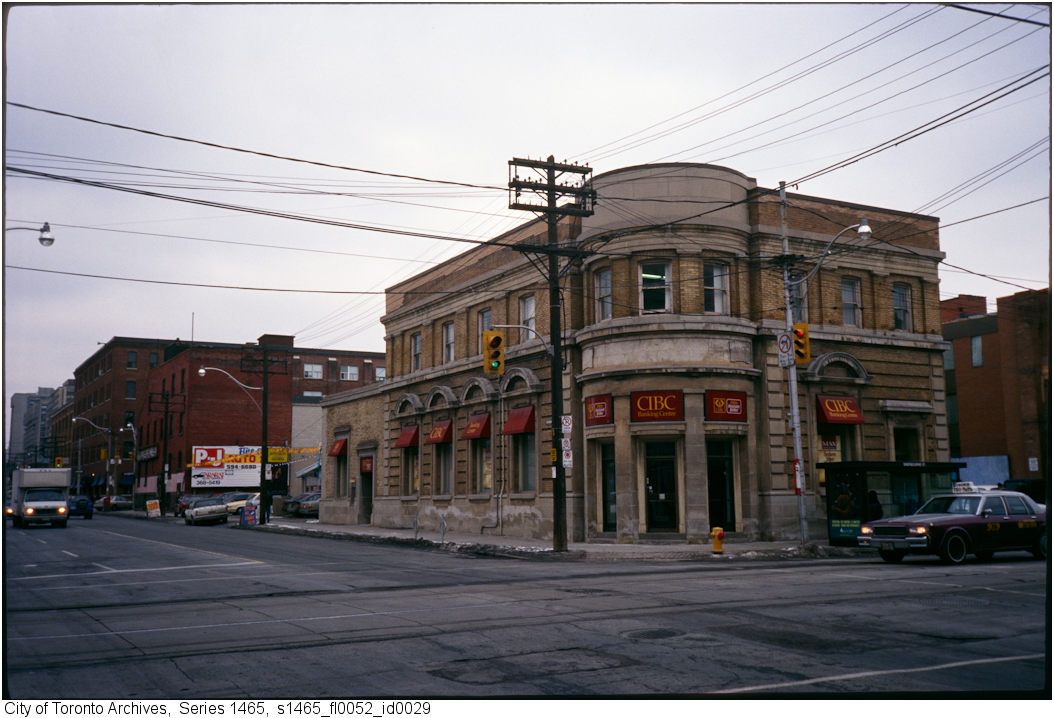
Filling for Long Island Mike .... the photo can't be any earlier than 1987 based on the Chevy Caprice taxicab at the right of the photo. 1987 was the first year that GM cars had the composite single glass headlights, which replaced the two individual halogen lamps. There also appears to be a late 1980s Oldsmobile parked just up the street.

And according to Wikipedia it can't be any later than 1994, which is when CIBC stopped using their 'chevron' logo.

http://en.wikipedia.org/wiki/Canadian_Imperial_Bank_of_Commerce
 
The former photo may be more 1990ish than 1980ish--or, whenever CIBC actually started to use "CIBC" as a logo...

Filling for Long Island Mike .... the photo can't be any earlier than 1987 based on the Chevy Caprice taxicab at the right of the photo. 1987 was the first year that GM cars had the composite single glass headlights, which replaced the two individual halogen lamps. There also appears to be a late 1980s Oldsmobile parked just up the street.

The rear part of this bank suffered a "bus-t in" as the Sun described it when a TTC bus lost control and crashed into the building in 1980.
And according to Wikipedia it can't be any later than 1994, which is when CIBC stopped using their 'chevron' logo.

http://en.wikipedia.org/wiki/Canadian_Imperial_Bank_of_Commerce

Thanks folks, for your investment in time in looking this stuff up. Or perhaps you just know this stuff by heart.

I can't get away with winging it here. :)
 
Then and Now for April 5.


Then. Six Ridout Street. c1918.

4836RidoutStc1918.jpg


Now. August 2011.

484.jpg
 
Mudslide

That sounds about right. I remember thinking at the time that adding the second bridge took all the fun out of it.

Does anyone remember the Don Valley Parkway 'landslide'? I can't remember which hill it was - it may have been near Chester Hill Dr - but I recall reporters talking to commuters who had no idea how to get home to the suburbs without the DVP.

It's funny but I was just looking for information on that mudslide and Google brought me to your post. :)
It was April 1969 on the northbound side.
I remember because my father was an engineer with Metro Transportation (Metro Roads and Traffic back then) and my sister and I piled in the car with him to go see it when he got the call.
It was pretty amazing.
 
It's funny but I was just looking for information on that mudslide and Google brought me to your post. :)
It was April 1969 on the northbound side.

Yes, the slide was near the end of Chester Hill Road where there had been considerable landfill - a garbage dump, I think.
Shortly after the landfill was completed, exhaust pipes were installed in order to allowed methane gas to escape.
The attached image shows the measures taken to prevent another slide.
 

Attachments

  • landslide.jpg
    landslide.jpg
    70.4 KB · Views: 351
Yes, the slide was near the end of Chester Hill Road where there had been considerable landfill - a garbage dump, I think.
Shortly after the landfill was completed, exhaust pipes were installed in order to allowed methane gas to escape.
The attached image shows the measures taken to prevent another slide.

I think it was farther up just before the Don Mills exit - also a landfill area, I think you've said. They planted trees there to prevent it from happening again.
 

Attachments

  • landslide.jpg
    landslide.jpg
    93.8 KB · Views: 349
I think it was farther up just before the Don Mills exit - also a landfill area, I think you've said. They planted trees there to prevent it from happening again.

I believe two things are being confused here. The newspaper article is the same spot as Goldies picture, the article shows the original retaining wall. It was not long ago, 199?, that the new retaining wall shown in Goldie's shot was installed. I remember them beefing it up and it was around the late eighties early nineties IIRC.
That area is right over the road, the landfill area has a much lower slope and more run off area at the bottom.
The land fill with the methane vacuum is further north, between the Leaside and DonMills bridges. I have documentaion of the landfill as I owned a house at the top of it. We had a test well in our backyard and two vacuum wells just outside of our rear fence. Every other yard has the test wells and they were read monthly.
The trees that are now there were very young when we moved into the house in 1994, most of the hill at that time was covered in daffadils. One of these days I should scan the maps and other documents I have regarding the landfill, it's quite interesting!
 
No, I think the photo in the article is of your backyard.:D

The Star said it was just west of the Don Mills overpass, and the Globe said it was behind Davies Crescent.

From the Globe: "Residents of Davies Crescent immediately above the slide area were not aware of the slide until police went to their homes to check on possible damage.

There was no loss of privately owned land but the bank was eaten away to within a few feet of the back fence at 54 Davis Cres."
 

Attachments

  • Globe.jpg
    Globe.jpg
    97.4 KB · Views: 305
  • Davies Cres.jpg
    Davies Cres.jpg
    105.2 KB · Views: 322
Last edited:
No, I think the photo in the article is of your backyard.:D

The Star said it was just west of the Don Mills overpass, and the Globe said it was behind Davies Crescent.

From the Globe: "Residents of Davies Crescent immediately above the slide area were not aware of the slide until police went to their homes to check on possible damage.

There was no loss of privately owned land but the bank was eaten away to within a few feet of the back fence at 54 Davis Cres."

I was having trouble reading the original article but, yes, that's correct!
So it was right beside DonMills and not at Chester hill!
54 is down near the east end of the street where the bank is much steeper. There is a concrete sewer structure there now. I was at 14 Davies atop the lower grade portion where the land fill is, which stops pretty much at 24 or 26 Davies.
My wife occasionally visits one of the original propery owners who remembers when they opened the landfill in 1960. All of the houses down O'Connor Dr. and Davies Cres. were already built and they watched as almost everything imaginable was dumped down the hill. It was only open for about three years. The vacuum system was installed much later, 1979 or so when methane was detected in some basements. We are still friends with some of the nieghbours there and visit from time to time. I must ask if anyone remembers the slide.
I do remember when Millwood Rd between Overlea and the rail line whent down the valley though. A friend has picture of the happenings around that one. They had Bell trucks parked in Leaside with telephone booths mounted on the sides of them as all the phone lines were cut.
But thats another topic, isn't it?
 
Then and Now for April 4.


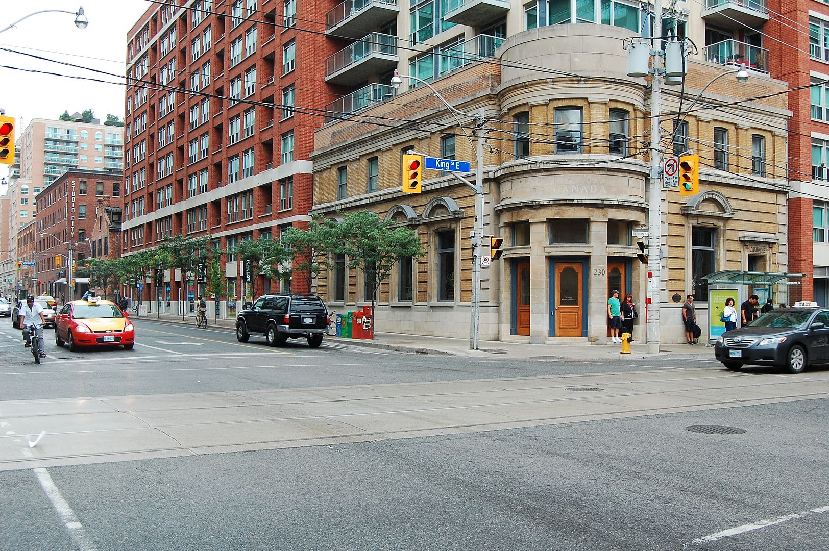
Then. Heya everyone. Here's something a little more recent. Sherbourne and King NE corner. 1980-ish.

480.jpg


Now. October 2011.

482.jpg

AHW: Thanks for the mention...I looked at those headlights myself and I am thinking late 80s or around 1990 for this top picture...
It is too bad that I can not read the license plates and the information on that taxi better...LI MIKE
 
I think it was farther up just before the Don Mills exit - also a landfill area, I think you've said. They planted trees there to prevent it from happening again.

When I was in Cub Scouts around 1975, we planted trees on one of the slopes, but I can't remember which one, now. I seem to recall it was right above one of the bunkers built into the slope.
 
Poster from Market Gallery

I'm not sure if this Toronto poster offer has been mentioned here before.
Looks like something that may interest some UTers.
 

Attachments

  • 1854 poster 1.jpg
    1854 poster 1.jpg
    39.1 KB · Views: 333
  • 1854 poster 2.jpg
    1854 poster 2.jpg
    96.2 KB · Views: 347

Back
Top