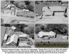
For the last 45 years I have been actively searching for any photo of "Bert's Turkey Palace", which was located at the north-east corner of the old Hwy 27 & Richview Side Road intersection. As part of my ongoing historical research work into the evolution of Hwy 27 from the 1940's onwards, I finally located a clear photo of the Turkey Palace (by sheer accident!) in the lower right hand corner of a 1961 MTO 8x10" B&W aerial negative of the Hwy 401/27/Richview interchanges. What luck!
It was torn down in 1967 to make way for the Hwy 427/401 mega-interchange. Today it would be located inside the exit ramp from Hwy 27 south to Eglinton, as shown in the extended posting in my Flickr account (see link below). Those who worked there have said "We didn't think it would ever go away and so we never took any photographs of it".
View attachment 22066
http://www.flickr.com/photos/40744368@N04/sets/72157640141974064
The restaurant was owned by Bert Hedges who was a popular amateur hockey official as well as owning 3 race horses named Bronze Turkey, Silver Turkey and Gold Turkey. The establishment was located on the south end of his farm which was also used to raise the live stock and tend for the horses. Hedges Blvd in Etobicoke was named after him.
If you look closely you can see a large artificial turkey on the top-front roof of the restaurant as well as two smaller ones on a sign (to the left of the car) which reads "Bert's Turkey Palace".
Look to my following Facebook album for more historical photos around this area from the 1950's and 1960's:
https://www.facebook.com/media/set/?set=a.1012819900130.1888.1814022886&type=1&l=6b0456455b
If anyone has any additional photos of Bert's Turkey Palace, or stories, then I would be most interested in receiving them and adding them to this collection for others to see in the future.
--------------------------------
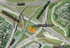
Location of "Bert's Turkey Palace", 2014 vs 1967 aerial comparison
View attachment 22067
This graphic shows where "Bert's Turkey Palace" would be located today, inside the Hwy 401/427 mega interchange. This mirrors the previous collage which showed the restaurant as it was in 1961. The red line is the old alignment of Richview Side Road (now Eglinton Ave) and the green line is the old alignment of the 4-lane Hwy 27, prior to both being re-routed in 1969. There was so much grading done in this area that it has **little relation** to what it once looked like. There are no visible remnants of the restaurant inside that off-ramp circle at ground level. The only untouched portion of that pre-1969 Richview community is the Richview United Church cemetery which you can see within the "U" shape on the left, squashed between the north and south bound lanes of Hwy 427.
As a bit of trivia, the evergreen trees that you can (almost) see in this image to the left and right of the green line are the same trees which once were on each side of the old Hwy 27 alignment.


") the abandoned York Mills/DVP ramp.
the abandoned York Mills/DVP ramp.