News   GLOBAL  |  Apr 02, 2020
 9.8K     0 
News   GLOBAL  |  Apr 01, 2020
 41K     0 
News   GLOBAL  |  Apr 01, 2020
 5.6K     0 

Yet you and others keep saying that they will run on the same tracks as CN freight trains. That simply will not happen.
You have quite the active imagination. The term I have consistently used is "mainline". Is every train in your world a freight? And have you ever considered the basis of many waivers, namely temporal separation? Freights occasionally use the Bala south of the by-pass too. And if that track is electrified (likely only to the Don Spur and up to Midtown) then the freight will have to comply with Metrolinx terms, not the other way around.

Meantime there's lots of options for paralleling the CN Bala up to RH, and then running the service into the Relief Line tunnel, ostensibly at Don Mills.
 
You have quite the active imagination. The term I have consistently used is "mainline". Is every train in your world a freight? And have you ever considered the basis of many waivers, namely temporal separation? Freights occasionally use the Bala south of the by-pass too. And if that track is electrified (likely only to the Don Spur and up to Midtown) then the freight will have to comply with Metrolinx terms.

South is not the debate here. Metrolinx could switch it to TTC Gauge if they so desire. Temporal separation is fine on a seldom used line. But what about a line that has freight almost hourly? I could get the stats for the line, but I know it is nowhere near the level of the O-Train line.
 
South is not the debate here. Metrolinx could switch it to TTC Gauge if they so desire. Temporal separation is fine on a seldom used line. But what about a line that has freight almost hourly? I could get the stats for the line, but I know it is nowhere near the level of the O-Train line.
Here is what I wrote. And then you got snarky, and continue to do so:
RER in the form of Metro vehicles that can run on mainline becomes the DRL at Don Mills and south to the core initially, and then across the southern part of the City to the Georgetown Corridor where it runs northwest on present Metrolinx track, either to the airport or and/or to Bramalea/Mt Pleasant. Electrified, 25kVAC, of course, with option for bi-voltage 750VDC to run on LRT tracks as well.
I studiously avoided trackage that isn't Metrolinx owned or operated. It's one of the determining factors for mentioning Bramalea. I added Mt Pleasant since the pathings already exist for diesel. That service would ostensibly remain hourly, perhaps only as a shuttle from Mt Pleasant (or further west) to Bramalea where the much more frequent RER/Metro would handle the task.

How do you spell "Relief"? How about from both ends and across the core? And through-running at Osgoode.
 
Last edited:
Here is what I wrote. And then you got snarky, and continue to do so:

I studiously avoided trackage that isn't Metrolinx owned or operated. It's one of the determining factors for mentioning Bramalea. I added Mt Pleasant since the pathings already exist for diesel. That service would ostensibly remain hourly.

How do you spell "Relief"? How about from both ends and across the core?

Someone on here was suggesting using a subway car on the Bala Sub. Sorry for pointing a finger at you, but my pointing is at anyone who thinks CN will allow it.
 
Someone on here was suggesting using a subway car on the Bala Sub. Sorry for pointing a finger at you, but my pointing is at anyone who thinks CN will allow it.
Quite a few posters have mentioned subway cars. As much as I think that a lesser choice for many reasons prior articulated, no-one has suggested running them on standard gauge track. The proposal has been to run them *beside* the CN Bala alignment, such that the present RH Line stations can still be served. And under the Canada Transportation Act (and references in others) that RoW can be attained from CN, with compensation for doing so set by the CTA. I've just finished using Google Satellite yet again to check for the needed space next to the Bala Sub. It's there!

This isn't rocket science. It's using what will be a very expensive undertaking to serve more than just what I call "The Pape Entitlement" with a subway. The whole purpose of a 'Relief Line' isn't to dump more people onto the existing subway. It's to *circumvent* the flow. And subway is not the best way of doing that. Metro style of trains is by far the leading world favourite, for many reasons. It does 'subway' and a hell of a lot more, cheaper, faster, and *onto mainline* where needed utilizing catenary at UIC height.
 
If the Richmond Hill line were straight and fast, you'd have a point. It isn't though, it's long and very windy down the Don River - at one point coming within 4,000 feet of the Victoria Park border of Scarborough!

Travel time on GO from Langstaff to Union is currently 42 minutes in rush hour (13 minutes to Oriole near Leslie TTC; 29 minutes from Oriole to Union) - and there's only one station in between!. If they build RER it will likely come with additional stations, so MU operation won't save much.

Finch to Union on subway (at least before they started messing with the signals) is only 28 minutes. How much time will those additional 6.4 km ( 5 stations) add? Well, Finch to Lawrence is 4 stations and 6.3 km and 9 minutes. So add a minute of dwell time ...

Who is going to take an RER train that only comes every 15 minutes and takes 42 minutes to Union, when the subway comes every 2-3 minutes and takes 38 minutes?

Other than a handful who actually work very near Union Station or perhaps on Queens Quay - very few.

Exactly. Out of all of the current GO lines, Richmond Hill is the least likely to be upgraded to RER. It's basically useless (connectivity-wise) south of Lawrence, except for the little bit near Gerrard.

Might as well stop the GO trains at Oriole/Leslie or even extend the DRL further up the tracks to Steeles or into Markham at Yonge and Highway 7. Then run GO RER from there.

This is pretty much what I was suggesting, only stopping it at RHC. It doesn't need to be full RER north of there either, a DMU type of service would likely be able to handle the demand.
 
The O-train is run along a line that is seldom used.


See that blue? See how it comes down from the north? That is the Bala Sub.

See the Blue that goes across the city? That is also CN. North of that, is Langstaff GO, Richmond Hill GO, and Gormley GO. Ignoring GO trains,, that line North of the Doncaster Junction is a very busy freight line.

There will be no waiver for non TC Compliant trains on that section. It would need to be seperated from the freight line.

Why would some kind of DRL service on the sub need to go North of Steeles? Thats further than the relief line north is intending to go in typical subway fashion, and outside of the Toronto border.

It could easily stay north of Steeles aka the York sub and still serve its purpose.
 
I'm sorry if I'm late to this and potentially get a bunch of facts wrong but does Via still run the Canadian on the Richmond Hill line when entering Union Station. If so, how will @steveintoronto's proposal work out if there are still heavy rail vehicles using the line, even if it's only 2-3 times a week?
 
If so, how will @steveintoronto's proposal work out if there are still heavy rail vehicles using the line, even if it's only 2-3 times a week?
In what way? The existing southern stretch of track would remain as is. Any passenger under catenary would follow the surmised DRL RER in tunnel using switches if the routes are interconnected. Catenary isn't proposed in my scenario for the Bala Sub save for the Don Spur when needed south to Union for HFR and/or a connection to a Midtown line if ever it should materialize. North of the CN freight bypass, catenary could only occur on separate tracks paralleling the present RoW, or a new RoW is established with the possibility of being elevated in parts, due to the much greater ability of Metro/RER type EMUs to climb and descend steeper grades than what diesel can achieve.

I suspect you've misread what I proposed.

The bottom line is...*even if conventional subway and it's own extended north of Steele's RoW*...to not maximize this "relief line" to the fullest would be folly on the level of...well...Toronto.

$Billions for four car trains up to Pape? It would be utterly ridiculous to not utilize the Relief Line to do far more than be a shuttle for Line 2 down to the core. This should be an almost complete *Bypass* of the present subway, not an interconnected relief.

One poster, @gweed123 I believe, mentioned DMUs as an extension of the north of Steele's reach of the Relief Line, an entirely pragmatic if not ideal solution to achieve much the same as what I propose. It means any parallel tracking could be contingent with the existing CN RoW, and a single track to suffice on a busy freight main to allow regular pathing on the three tracks. To add two tracks would render interconnection moot, as they could be solely for the use of Metrolinx, and thus under catenary. Problem solved.
how will @steveintoronto's proposal work out if there are still heavy rail vehicles using the line, even if it's only 2-3 times a week?
The problem isn't the occasional freight, it's the clearance, both height and platform.

As per catenary, in fact in this Metrolinx doc, double-stack is cleared:
3.6.2.2 OCS Vertical Clearance The contact wire height needs to be designed to accommodate the multiple types of trains that operate along the GO corridors (i.e., Double Stacked Freight, GO Electric Multiple Units (EMUs), GO Bi-level trains, VIA Rail, etc.). Therefore, the height of the contact wire was designed to accommodate the highest vertical clearance, which is Double Stacked Freight and GO Bi-Levels (see Figure 3-12). The height of the portals/cantilevers used to support the OCS wires over the electrified tracks will range between approximately 7.6m to 12m above the top of the highest rail. Contact wire height will range from 6m to 7.6m.
Pg 65 http://www.metrolinx.com/en/electrification/docs/GO Rail Network Electrification Environmental Project Report_Volume 1.pdf
 
Last edited:
Why would some kind of DRL service on the sub need to go North of Steeles? Thats further than the relief line north is intending to go in typical subway fashion, and outside of the Toronto border.

It could easily stay north of Steeles aka the York sub and still serve its purpose.

Well, way back when, the old city of Toronto decided to build a subway. Way back then, it went north of Bloor to Eglinton, which was outside it's boundary. It saw ridership, and was lengthened.

Now, the city of Toronto is much larger, and there is a case for the ridership. So, extending the line beyond the borders of the city is happening.
 
I can see the TBM's tunneling under Pape Avenue, even after the curve, up to Kiwanis Parkette. There could be a bridge to the west of Millwood Road.
Pape Donlands.jpg


With only a parking lot, they can dig a curve from the bridge to under a new TBM site in the parking lot. Continuing under Overlea Blvd.
Millwood Overlea.jpg


It's the curve from Overlea Blvd. to Don Mills Road that could present some problems. Maybe they replace some schools in the construction.
Overlea Don Mills.jpg
 
My guess is that it will actually end up following Gateway and approach Eglinton from the Southeast. It avoids the tight 90 degree turn surrounded by structures and lets a Flemingdon station be far more central than otherwise.
 
tentially get a bunch of facts wrong but does Via still run the Canadian on the Richmond Hill line when entering Union Station. If so, how will @steveintoronto's proposal work out if there are still heavy rail vehicles using the line, even if it's only 2-3 times a week?
That they do! Goes by my condo a few times a week.
 
I can see the TBM's tunneling under Pape Avenue, even after the curve, up to Kiwanis Parkette. There could be a bridge to the west of Millwood Road.
What TBMs? The design is already mostly finalized from Danforth to north of Mortimer as cut-and-cover for some storage tracks for Relief Line South. I don't think they are going to bother launching TBMS to drill 800 metres from Westwood to just north of O'Connor.
 
What TBMs? The design is already mostly finalized from Danforth to north of Mortimer as cut-and-cover for some storage tracks for Relief Line South. I don't think they are going to bother launching TBMS to drill 800 metres from Westwood to just north of O'Connor.

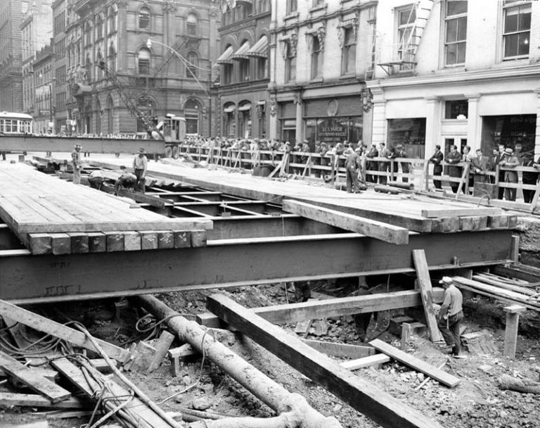
That'll mean cut-and-cover along the north section of Pape Avenue to the side of the Don River Valley, just like what was done with the original Yonge Subway.

8f36-6101-2-768x608.jpg

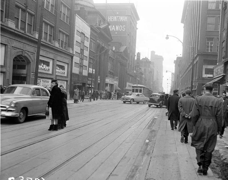
Diverting the the traffic as they dig down.

9603-6288-3.jpg

Using temporary beams to carry traffic. No heavy trucks please.

From link. Missing would be all the 3+ story buildings along Pape Avenue.
 

Back
Top