News   GLOBAL  |  Apr 02, 2020
 8.4K     0 
News   GLOBAL  |  Apr 01, 2020
 39K     0 
News   GLOBAL  |  Apr 01, 2020
 4.7K     0 

I wonder if they're going to run the park under or flush with the Spadina and Bathurst bridges?
It's a good question, but before it even gets to pertain to the ostensible park deck, the clearance under those bridges might allow for two levels of track, and that could radically increase the capacity for Union to handle if a pair of tracks is elevated around the south side of the Union shed to handle RER traffic.
 
Do you mean Mouth of the Creek park? It will be beside the library, with access beneath the Bathurst bridge.
 
Bit of a problem with the train on the Georgetown corridor in the pic: They've got the loco on the wrong end...tsk, tsk, tsk...

lol. Us UT'ers would be the ones to notice that...

The bridges are good for now

Yeah. I certainly don't see why we couldn't at least extend it to the edge of the Ordinance Triangle.
 
What about allowing for a row of point towers between the western edge of the rail deck park and the Ordinance Triangle, such that any future rerouting or removal of the Gardiner can be accommodated with an off ramp to Front Street that would be hidden from view by the towers? Just thinking long term...
 
What about allowing for a row of point towers between the western edge of the rail deck park and the Ordinance Triangle, such that any future rerouting or removal of the Gardiner can be accommodated with an off ramp to Front Street that would be hidden from view by the towers? Just thinking long term...

You mean like the Front Street Extension proposed? That project that city council voted to abandon and remove from their official plan?
 
You mean like the Front Street Extension proposed? That project that city council voted to abandon and remove from their official plan?

Yes exactly that. It's time council revisit it. The city has dramatically changed since then and we need the extra capacity.
 
Yes exactly that. It's time council revisit it. The city has dramatically changed since then and we need the extra capacity.
There is a development plan in place for that vacant land and its moving ahead. The boat has sail.

Never supported the Front St extension and glad its dead. I wish the eastern section was removed as plan, but its not.

With all the development plan for Front St, making it 6 lanes between Bathurst and Spadina will a bitch on the area and this park if built.

Bring back the Front St Streetcar that used to run there at one time.

Look what the Gov of NY is thinking on doing for Syracuse elevated section. I use 690 to get to part of 81 going south

Is Cuomo Ready to Rid Downtown Syracuse of I-81?
 
...
Never supported the Front St extension and glad its dead. I wish the eastern section was removed as plan, but its not.
...
Bring back the Front St Streetcar that used to run there at one time.
...

And have that Front Street streetcar run along its own private right-of-way to Liberty Village.
 
Yes exactly that. It's time council revisit it. The city has dramatically changed since then and we need the extra capacity.

Puh-lease. The last thing we need to do is funnel more cars into an area that is already congested. I really don't want to get into another debate about induced demand, because it's not a debate. I do prefer more efficient proposals for transit and active modes to be able to connect to Bathurst, and so this circles back to our discussion about extending the rail deck west of Bathurst.
 
Front St. stops at Bathurst so how would you get that streetcar to Liberty?

A streetcar only viaduct, like they have in The Netherlands and Europe.

stock-photo-newly-built-elevated-tram-track-in-the-hague-holland-13184533.jpg


They were going to build a wide viaduct for automobiles, but narrow it for streetcars, bicyclists, and pedestrians only.

original.jpg


Unless the view of the railway tracks might get spoiled.
 
It's a very simple build to veer the Gardiner north-east, just east of Strachan. Have it cross the tracks above ground and either terminate as an off-load onto a Front St. Extension, or in addition to this, run it underground a very short distance until it rises above the surface just east of Bathurst, eastbound lanes on Adelaide, westbound lanes on Richmond. That's a viable offloading of the Gardiner that would allow the elevated expressway, eventually, to be removed. Of course there would be another exit in the Gardiner's existing right of way at Strachan. I'd suggest at least leaving room for this between the western edge of the rail deck park and the Ordinance Triangle. I'd also develop the western edge of the rail deck park to hide this right of way. Also develop each corner of Tecumseh and a Front St. Extension. Front street would run into Liberty Village or Douro St.. Front Street doesn't have to be widened to six lanes. Two lanes eastbound and two lanes westbound is fine, basically the way it is today with slight modifications. None of this Gardiner business has to happen any time soon, but it would be nice to have that option down the road. What's actually a big deal about this is that it also says scrap the Gardiner Hybrid idea. Simply remove the existing elevated Gardiner east of Strachan to the DVP. The DVP exits at Richmond and Adelaide are where the southern end of the DVP would terminate. I realize we can't even get Council to remove the Gardiner east of Jarvis right now, but give Council 10 or 15 years. Also, the Hybrid absolutely cannot get funding right now or in the near future because the DRL and ST take priority. We'll be lucky if we can fund those.
 
Last edited:
From the Union Station Revitalization thread, ten years ago.
Re: Union Train Shed Replacement & $600 million in GO up

^ adding to the above.

www.toronto.ca/union_stat.../intro.pdf

Components and ownership of the Station complex
The Station complex is composed of the following major elements:
• the station building (or Head House) at both ground and concourse levels;
• the moats along Front Street, turning south along both Bay and York Streets to the start of the teamways at the viaducts;
• the teamways running south from the moats along both Bay and York Streets;
• the trainshed, its platforms and tracks;
• the VIA concourse;
• the east GO concourse and planned west GO concourse; and
• the service areas directly beneath the arrival/departure hall currently used for storage, mechanical uses, parking and loading docks.

The City of Toronto owns all the lands and the building south of Front Street between York and Bay Streets north of the Canadian National Railway’s High Line, plus the York West Teamway. GO Transit owns the rail corridor roughly stretching between the Don River and Strachan Avenue, and the former CP Express site across Bay Street, including the Bay East Teamway. Between York and Bay Streets, GO Transit owns
a 27 foot high three-dimensional stratum or envelope through the City of Toronto’s property which houses the trainshed, tracks and platforms. The City of Toronto owns the building below and the air space above the GO envelope.

Several other entities have leasehold or other contractual rights to space in the Station and neighbouring properties enjoy rights of access through the block for pedestrian routes.

----

So, it appears GO owns the train shed, tracks and platform, but not the space above that, or the building (via waiting area) below.

I've posted extensive reference to the "Esplanade Agreement" also known as the "Tripartite Agreement" prior in this forum. From the above quote, it appears *some* at City Hall are already aware of this. So why did Council have no clue on it?

Edit to Add: Page 197 (link above), para 12, defines "Union Station" as including:

"[at the least]...all the tracks therein and leading thereto, between Yonge Street and Peter Street".

https://books.google.ca/books?id=BupHAQAAMAAJ&pg=PA572&lpg=PA572&dq=Esplanade+or+Tripartite+Agreement&source=bl&ots=1q9Pyh4ENJ&sig=B_54nS2NfC0ZCshhgm5qZje8RhQ&hl=en&sa=X&ved=0ahUKEwjzrZ2slM7PAhWo34MKHRFMD7cQ6AEIKDAC#v=onepage&q=Esplanade or Tripartite Agreement&f=false

The operating context of that may dilute the pertinence to Rail Deck Park, but it might also make the City's ownership of Union Station completely inclusive of proceeding with that stretch of decking without hindrance from affected parties, or if contested, relatively simple court rulings to proceed.

Edit Monday 10 Oct:
See page 192, paragraph 4 'Esplanade Agreement' linked above. This is very interesting, as it allows (gist) 'any private landowner, or tenant with property on the north side of the Esplanade but south side of the new CPR alignment in whole or in part opposite to bridge at their own expense subject to the conditions of the Railway Act'.

A term showing throughout this Agreement is "conveyance", as The Esplanade is a "highway" and the use by the railway companies is contingent on same ceding land they occupy or own in replacement to the City (and public use) for a new parallel road. At no time does the City cede ownership of The Esplanade, and that's made clear in paragraph 2, page 191, where access to that land (gist) "reserving all existing rights....(for) construction, reconstruction, inspection or repair of sewers and water mains along or under said portion of street". The term "leasehold" also appears, esp relating to the York St diversion to the Esplanade.

The Esplanade later fell under the jurisdiction of the City/Federal Harbour Trust: (But note, not the Tripartite Agreement which affected only railway use)

[...]
The Harbour Trust was also given authority over the Esplanade plan. The original 1817 plan intended to build a public walk and garden along the waterfront, just south of Front Street. The province's plan was largely ignored and the City allowed the use of the shore line to be used for wharves and docking. In 1837, a new plan was developed for the Esplanade. In this plan, the Esplanade would be built just south of Front, and the waterfront extended south to the "Windmill Line", some 100 yards south. The new lands would be used for port uses.[2] The Esplanade itself would become mostly railway lands.

The intrusion of the railways into the waterfront in the 1850s to 1890s period started to crowd out recreational uses. In 1892, a legal agreement solidified the railways usage of the waterfront. In 1893, a new plan was developed to extend landfill another 600 feet (180 m) south, and a new Lake Street (today's Lake Shore Boulevard) established along the then current waterfront edge.[3] The problem of silting, and the increasing amount of sewage being dumped in the harbour, required ongoing dredging efforts. Other works by the Harbour Trust including a breakwater at the Don River and a breakwater at the Queen's Wharf to protect the entrance to the harbour.[4]
[...]


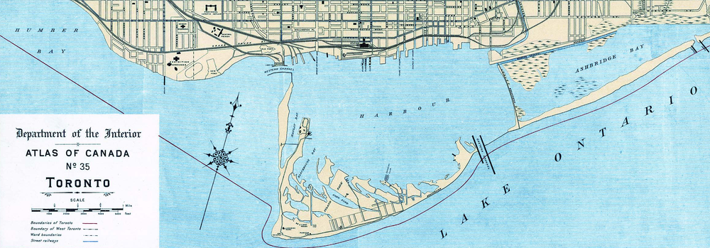
Map of Toronto Harbour in 1906 before the infilling of Ashbridge's Bay
https://en.wikipedia.org/wiki/Toronto_Harbour_Commission#cite_note-wickson27-2
 
Last edited:

Back
Top