News   GLOBAL  |  Apr 02, 2020
 9.5K     0 
News   GLOBAL  |  Apr 01, 2020
 40K     0 
News   GLOBAL  |  Apr 01, 2020
 5.4K     0 

The existing subway's tail tracks are too far east of the Sheppard/Don Mills intersection to simply curve southwards. It would at least have to enter the Hwy 404 corridor in order to swing back, but more likely so the swing back would have to occur at Victoria Park Ave. Now while 22 Victoria Park has similar ridership levels to the 25 Don Mills, it misses too many nodes en route. So although it'd be intriguing if a DRL ran all the way down it to the Beaches then across Queen, one must argue that we keep Sheppard subway and the DRL as separate lines.

So here is what the report has to say about the Crosstown East:


Looks like confirmation that they are planning on operating it as an easterly extension of the Crosstown, so long as there is no complications upon further studying.

Confirmation that no SELRT, no Sheppard station on Crosstown East. Confirmation that the SM-LRT EA needs to be reviewed, and that Kennedy Station will need to be reconfigured. Not exactly surprises.

And finally, to settle the earlier debate, yes the Scarborough-Malvern LRT is being officially renamed as the Crosstown East in the planning documents. This is consistent with the extension to Renforth in the west being renamed to Crosstown West. I like the new name, it is simple, consistent with the concurrent plan in Etobicoke, and with it no longer being a standalone line, accurate.

Perhaps this thread title should be renamed.
 
Crosstown East is shovel ready. Infrastructure Ontario Procurement process takes more then two years for Crosstown East to start construction. What happens if the Provincial Conservatives who are pro
subway anti LRT win the next Provincial election, all this work and planning goes down the drain. I think it would be more wise for the TTC to build the Crosstown East because it could start construction by the end of next year.
 
So here is what the report has to say about the Crosstown East:

This line is a huge win for Scarborough. You can tell just by looking at the bus map that the ridership already exists, since the entire route of Crosstown East is currently handled by multiple bus routes with frequent service, plus two express buses on top of all that. That's a lot of buses that will be off the road in the near future. Crosstown East will also have connections to the Lakeshore GO train.

Screen shot 2016-01-21 at 12.58.50 AM.png


And at the end of the line is a large university that has ambitious expansion plans but is not accessible by rapid transit at the moment. Hopefully not for long!

Screen shot 2016-01-22 at 12.30.19 AM.png
 

Attachments

  • Screen shot 2016-01-21 at 12.58.50 AM.png
    Screen shot 2016-01-21 at 12.58.50 AM.png
    262.8 KB · Views: 860
  • Screen shot 2016-01-22 at 12.30.19 AM.png
    Screen shot 2016-01-22 at 12.30.19 AM.png
    801.1 KB · Views: 938
Last edited:
Extending to Sheppard is just one more stop. I really don't get why they cut it short. Is it that expensive to go over the 401?
 
Extending to Sheppard is just one more stop. I really don't get why they cut it short. Is it that expensive to go over the 401?

- Uncertainly about the future of Sheppard LRT
- Doesn't fit within the existing funding commitment. We're talking almost 2km more to get to Sheppard, that will require more money.
 
- Uncertainly about the future of Sheppard LRT
- Doesn't fit within the existing funding commitment. We're talking almost 2km more to get to Sheppard, that will require more money.

I can see the money bit. But I don't get what the Sheppard LRT has to do with anything. The subway wasn't planned for that far anyway. So it's either LRT or a bus at that intersection. Now, all those who live in that northeast corner have no connection with this LRT. Getting to Sheppard would have let them intercept a lot of buses.
 
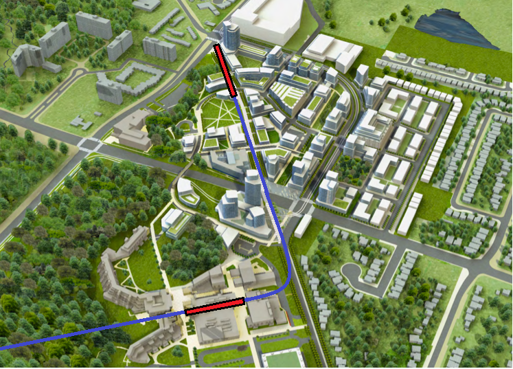
Looking at that UTSC figure, it looks like the LRT should cut into UTSC from the south/west and then continue on Military Trail to rejoin Morningside - instead of going up to Ellesmere and coming back down south into the University.
 
Could they not build an LRT bridge that diverts off Morningside prior to Ellesmere (where it bridges over Highland Creek) and route directly through the campus with an underground station in the commons, York U style?
 
Could they not build an LRT bridge that diverts off Morningside prior to Ellesmere (where it bridges over Highland Creek) and route directly through the campus with an underground station in the commons, York U style?

That would cost quite a bit more and not accomplish much, the planned station location is still close enough to the existing part of the campus, and they are planning to expand on the north side of Ellesmere.
 
They have to widen the bridge anyway, so they may as well just build a new LRT only bridge - same cost.
I don't know the area well enough, but I could see an at-grade station, partly underground (cut-and-cover) or elevated all working. Could be some extra cost depending on option chosen
 
There's a Centennial College building at the northeast corner of Morningside and Ellesmere that would be overlooked by that plan. While it might be close to the military trail stop the topography of the area makes it a bit difficult. I don't think its justifiable to not have a stop at Ellesmere, buses like the 38 and 95 are would benefit from a direct connection.

To be honest what is being proposed I think is the best solution. As great as it would be to have a stop in the middle of the existing Utsc campus, it seems like having it come from over the creek and stop underground would be excessively expensive. As it stands the campus is not that large in area, you can walk from the southernmost Social Sciences building to the IC at the corner of ellesmere and military in ten-ish minutes. It doesn't have the gross distances the York or even St. George has.
 
This one long Pearson to UTS route is very logical. People don't like transfers and this offers true crosstown travel.
 
This is kind of what I was thinking:


For the record, Military Trail will be realigned and the existing street will become a landscaped pedestrian route.

Screen shot 2016-01-23 at 1.05.29 AM.png


Therefore the LRT route may actually look more like this:

Screen shot 2016-01-23 at 1.05.04 AM.png


You can read more about this in the 2011 U of T master plan.
 

Attachments

  • Screen shot 2016-01-23 at 1.05.04 AM.png
    Screen shot 2016-01-23 at 1.05.04 AM.png
    386.1 KB · Views: 532
  • Screen shot 2016-01-23 at 1.05.29 AM.png
    Screen shot 2016-01-23 at 1.05.29 AM.png
    361.7 KB · Views: 532

Back
Top