News   GLOBAL  |  Apr 02, 2020
 9.9K     0 
News   GLOBAL  |  Apr 01, 2020
 41K     0 
News   GLOBAL  |  Apr 01, 2020
 5.6K     0 

It’s only a real loop if it extends east and connects with Kipling as well. But think of the advantages. You get on the train and are supposed to be heading one direction. Woops I’m going the wrong way. Don’t worry it’s a loop. You don’t need to transfer. You’ll safely, warmly, comfortably get to your destination. It will just take you an extra hour. Now that my friend is world class, it is treating people with dignity and giving people what they deserve.

well exactly a loop is a loop (i.e. one continuous line, just like Line 1). the advantage is that we'd never waste $ building north or east in low density suburbia. they can have trains short-turn at STC or Kipling, so that only half the trains go to Sheppard making the full loop. not sure if you even understood what I was saying, but here's a crudely drawn map to illustrate.

Screen Shot 2023-02-28 at 11.15.35 AM.png


this wouldn't add any extra time vs having to transfer at McCowan. in fact it would save time. I have no idea what going on about.
 
and if my aunt were my uncle. Line 4 uses Toronto gauge. I don't see a light metro being anything other than standard.

Gauge are not that important, except for shifting vehicles from one route to another.

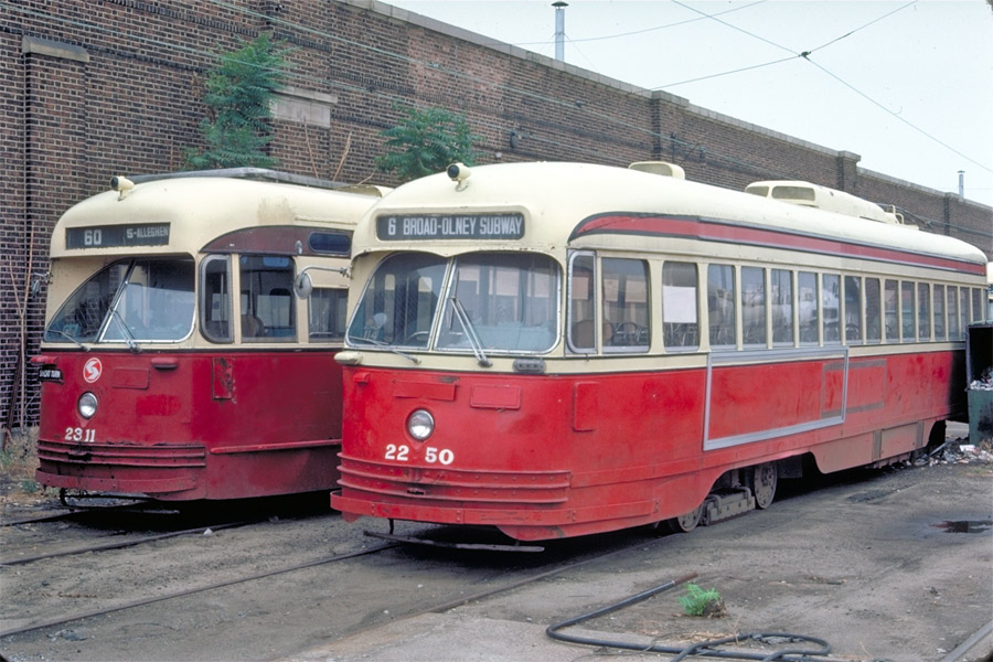
In October of 1975, 60 trolleys were destroyed in the disastrous Woodland Depot fire in Philadelphia, Pennsylvania. The track gauge in Philadelphia was 5 ft 2 ¼ in (1,581 mm), while TTC used 1,495 mm (4 ft 10 ⅞ in). Standard track gauge is 1,435 mm (4 ft 8 ½ in). 30 used PCC streetcars were purchased from Toronto for $12,500 each, as is. The total cost of the purchase was $375,000. The cars had been built in 1946: eleven ex-Kansas City cars built by St. Louis Car Co., and nineteen ex-Birmingham cars built by Pullman-Standard. The trucks (wheel assemblies) under the cars were re-gauged by TTC crews at Hillcrest Shops at $4,000 each. The first shipment was on March 15, 1976. The last shipment was on November 22, 1976.

In 1976, trolley cars on the SEPTA system were equipped with wheels at the tops of the trolley poles to collect power. The Toronto cars arrived with slider-shoes on the poles instead of wheels, and it was decided to retain sliders on the cars as an experiment. Later in 1976 it was decided to convert all SEPTA surface rail vehicles to the slider-shoe type of power collection. After the overhead wire fittings were changed over for slider operation, Luzerne PCCs received sliders during the summer of 1976. Route 23 was the first line to be totally changed over to trolley slider-shoe operation. It it was not until 1980 that Woodland and Callowhill cars had their trolley pole wheels replaces with shoes

See link.

2311-2250_july-13-1977_luzerne_szilagyi-kodachrome_900px.jpg

ex-Toronto SEPTA PCCs 2311 and 2250 at Luzerne Depot.
Both built in 1946, differences between the Pullman (2311) and St. Louis Car (2250) sheetmetal are apparent.
Mike Szilagyi photo, July 13, 1977
15x15green.gif
 
well exactly a loop is a loop (i.e. one continuous line, just like Line 1). the advantage is that we'd never waste $ building north or east in low density suburbia. they can have trains short-turn at STC or Kipling, so that only half the trains go to Sheppard making the full loop. not sure if you even understood what I was saying, but here's a crudely drawn map to illustrate.

View attachment 458999

this wouldn't add any extra time vs having to transfer at McCowan. in fact it would save time. I have no idea what going on about.
I agree. Low density suburbia is not how I would describe sheppard east of Victoria park or sheppard west of Yonge. I can’t even think of one single detached house in those neighborhoods. Definitely no McMansions. No siree Bob. These are much more dense neighborhoods than what’s to the immediate east or west. #BuildTheLoop
 
I agree. Low density suburbia is not how I would describe sheppard east of Victoria park or sheppard west of Yonge. I can’t even think of one single detached house in those neighborhoods. Definitely no McMansions. No siree Bob. These are much more dense neighborhoods than what’s to the immediate east or west. #BuildTheLoop

sure, but that's not what we are talking about. we're talking about going further east and north to Markham and Pickering.
 
sure, but that's not what we are talking about. we're talking about going further east and north to Markham and Pickering.
This is right. VMC has a plan. Richmond hill has a plan. the STC has a plan. Pickering town centre and Markville mall not so much. Just a sea of parking lots out there. Agreed.
 
I agree. Low density suburbia is not how I would describe sheppard east of Victoria park or sheppard west of Yonge. I can’t even think of one single detached house in those neighborhoods. Definitely no McMansions. No siree Bob. These are much more dense neighborhoods than what’s to the immediate east or west. #BuildTheLoop
Can you stop with the concern trolling? It's getting really old.

We get it, subways should not run everywhere in suburbia. I don't disagree. But this endless string of posts is getting positively exhausting to read.
 
This is right. VMC has a plan. Richmond hill has a plan. the STC has a plan. Pickering town centre and Markville mall not so much. Just a sea of parking lots out there. Agreed.
Yes, enough of the sarcasm. Anymore, and it's vacation time.

42
 
This is right. VMC has a plan. Richmond hill has a plan. the STC has a plan. Pickering town centre and Markville mall not so much. Just a sea of parking lots out there. Agreed.
honestly the subway should have never been extended to those places. it's called buying votes. the core of the city will forever subsidize these extensions.

icy0ezglcxy91.png


you see the part of the map where it's red in every direction? that's the only place where subways/metros could theoretically justify being built. why? because it actually has the population density required to not be subsidized in perpetuity. an area needs at minimum a 10,000 per square km population density to justify it economically. otherwise it just bleeds money in operational cost yearly. Line 4 will always be subsidized no matter how far you extend it. the yellow belt will never have the population density to justify subways. you just want it or feel like you deserve it because you live in one of these suburban areas. GO can fill the suburban need if it's scaled properly like an S-Bahn. if the GO train is too expensive then talk to your MP about fare integration, which should happen anyways in my opinion.
 
I will say that I’ve become rather partial to the loop recently, not because I actually want to see Bloor trains ever turning up at Sheppard / Yonge, but because overlapping the services nicely solves all the arguments about which lines need what connectivity.
 
honestly the subway should have never been extended to those places. it's called buying votes. the core of the city will forever subsidize these extensions.

View attachment 459021

you see the part of the map where it's red in every direction? that's the only place where subways/metros could theoretically justify being built. why? because it actually has the population density required to not be subsidized in perpetuity. an area needs at minimum a 10,000 per square km population density to justify it economically. otherwise it just bleeds money in operational cost yearly. Line 4 will always be subsidized no matter how far you extend it. the yellow belt will never have the population density to justify subways. you just want it or feel like you deserve it because you live in one of these suburban areas. GO can fill the suburban need if it's scaled properly like an S-Bahn. if the GO train is too expensive then talk to your MP about fare integration, which should happen anyways in my opinion.
This is ignoring all the plans to intensify STC and Vaughan MCC
 
honestly the subway should have never been extended to those places. it's called buying votes. the core of the city will forever subsidize these extensions.

View attachment 459021

you see the part of the map where it's red in every direction? that's the only place where subways/metros could theoretically justify being built. why? because it actually has the population density required to not be subsidized in perpetuity. an area needs at minimum a 10,000 per square km population density to justify it economically. otherwise it just bleeds money in operational cost yearly. Line 4 will always be subsidized no matter how far you extend it. the yellow belt will never have the population density to justify subways. you just want it or feel like you deserve it because you live in one of these suburban areas. GO can fill the suburban need if it's scaled properly like an S-Bahn. if the GO train is too expensive then talk to your MP about fare integration, which should happen anyways in my opinion.
This doesn’t really hold water and most UTers know it. Firstly, there are large pockets of density outside the core- I see lots of red as you identified across Scarborough, North York, northern Etobicoke, Peel and northern Markham/Vaughan. The GTA is not as low density as you might like to believe.

Secondly, Toronto’s subway ridership comes from high quality, frequent buses. It has higher ridership than every American system besides NYC, despite being far less dense than places like Chicago or Boston. You see Line 1 on your density map? That’s the wealthiest, and lowest density, part of the city once you get a block outside NYCC. Riders are obviously coming on buses, and the data supports this.

I could go on, but the point is rapid transit is viable in more places than you think; subways here serve as trunks for other modes, not just to serve a corridor itself. Was line 4 overbuilt? Maybe. But Sheppard has been a failure in part because it has not gone far enough to capture/replace many bus routes. The denser grid in Scarborough would feed a very large number of riders onto it if Line 4 were extended, many which simply go to a different line today.
 
This is ignoring all the plans to intensify STC and Vaughan MCC

well hopefully that helps with attracting more ridership. as of now some of the lowest ridership numbers come from stations located on Line 3, Line 4 and the Vaughn extension. typically these extensions can only be justified if they are a well connected regional hub. it's more the stations in between that attract the very lower ridership numbers. the Bessarion's, Leslie's etc... and examples of that exist on Line 1 and 2 as well. Yonge/Sheppard and Don Mills actual do quite well, so I see your point.

the highest ridership numbers still mostly come from stations located south of Bloor and it's pretty obvious why that's the case and why there should be more of them built in the future.
 
This doesn’t really hold water and most UTers know it. Firstly, there are large pockets of density outside the core- I see lots of red as you identified across Scarborough, North York, northern Etobicoke, Peel and northern Markham/Vaughan. The GTA is not as low density as you might like to believe.

Secondly, Toronto’s subway ridership comes from high quality, frequent buses. It has higher ridership than every American system besides NYC, despite being far less dense than places like Chicago or Boston. You see Line 1 on your density map? That’s the wealthiest, and lowest density, part of the city once you get a block outside NYCC. Riders are obviously coming on buses, and the data supports this.

I could go on, but the point is rapid transit is viable in more places than you think; subways here serve as trunks for other modes, not just to serve a corridor itself. Was line 4 overbuilt? Maybe. But Sheppard has been a failure in part because it has not gone far enough to capture/replace many bus routes. The denser grid in Scarborough would feed a very large number of riders onto it if Line 4 were extended, many which simply go to a different line today.

i already addressed this before i saw your post, but those pockets you describe are the only place they can justify building stations. Line 4 would be more successful as an express line, eliminating the three stations in between Yonge and Don Mills and routing all buses to those major hubs. bus routes already connect to Bayview and Leslie yet they still attract very lower ridership. the station that attracts the highest ridership on Line 4 (Don Mills) is also the station where most buses are frequently routed to, which is not surprising.
 
i already addressed this before i saw your post, but those pockets you describe are the only place they can justify building stations. Line 4 would be more successful as an express line, eliminating the three stations in between Yonge and Don Mills and routing all buses to those major hubs. bus routes already connect to Bayview and Leslie yet they still attract very lower ridership. the station that attracts the highest ridership on Line 4 (Don Mills) is also the station where most buses are frequently routed to, which is not surprising.
I don't see how it's going to be more successful by eliminating the three intermediate stations. It may have saved on some operating cost, likely not by much. TTC would have to run more frequent local bus to cover the Don Mills to Yonge distance. Less desification occur along Sheppard East, so the city would collect less development fees. Interesting how people on UT have/had actuallly advocated have a station added at Willowdale Av. - to make the line more useful.

The Bayview and Leslie buses would not be routed to Yonge or Don Mills station because that is silly route planning and riders will complain (they do not like their routes bifurcated). Don Mills has the highest ridership not just because it has multiple bus routes routed there, it is at a dense node, and also being a terminus station - 25 Don Mills and 85/985 Sheppard East feeds it. Two routes with much higher ridership than 11 and 51.
 
This doesn’t really hold water and most UTers know it. Firstly, there are large pockets of density outside the core- I see lots of red as you identified across Scarborough, North York, northern Etobicoke, Peel and northern Markham/Vaughan. The GTA is not as low density as you might like to believe.

Secondly, Toronto’s subway ridership comes from high quality, frequent buses. It has higher ridership than every American system besides NYC, despite being far less dense than places like Chicago or Boston. You see Line 1 on your density map? That’s the wealthiest, and lowest density, part of the city once you get a block outside NYCC. Riders are obviously coming on buses, and the data supports this.

I could go on, but the point is rapid transit is viable in more places than you think; subways here serve as trunks for other modes, not just to serve a corridor itself. Was line 4 overbuilt? Maybe. But Sheppard has been a failure in part because it has not gone far enough to capture/replace many bus routes. The denser grid in Scarborough would feed a very large number of riders onto it if Line 4 were extended, many which simply go to a different line today.

There are large pockets of density, yes, but, where are all of these people going?

If it's somewhere close by, subways are useless, since, stations are far apart in the suburbs.

If it's downtown, sure, they have a way that's quicker than the bus. BUT, it's going to be slower than a car, and much slower than a train. Building the subway infrastructure is also way more expensive than building out the train network (more stations, electrifications, etc). Furthermore, sure, subway stations could capture bus routes, but, that's not a great argument, since, so can GO stations. Each GO station should have big bus terminals with people getting on and off, and that's where the nodes and density should be focused around. Integrate the fares!

If they are travelling to somewhere across the city, say, Scarborough to YYZ, then, well, all of the options are bad except for the car. No way to make trains work (unless the midtown railway corridor is resurrected for passengers). You'll be able to eventually (probably) commute most of the distance via the Eglinton Crosstown, but, even that will likely be dreadfully slow from end-to end, not to mention the last mile part of the trip. The only good solution there is to ensure increased housing mobility and being able to get a place to live closer to where you work.
 

Back
Top