Another decade, another Gardiner Distressway Discussion
Some recent posts on the forum about the Gardiner (and decking the rail corridor) reminded me I had gigs of stuff on the old laptop that I forgot to share. Pretty sure this isn't buried in the Gardiner threads.
Genesis: A decade a half ago, a young engineer named
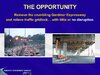
Jose Gutierrez approached me about doing some design work for his pet project. I thought his idea needed massaging, but basically it was brilliant... removing the crumbling
"psychological" barrier to the waterfront (Gardiner), while mitigating the
real waterfront barrier - the below grade rail corridor west of Union Station (as well as the elevated rail berm east of Union).
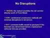
The genius of his idea was it would have avoided most of the nightmare of Boston's "Big Dig" (12 years of havoc and mayhem, huge budget over-runs, and nearly a half $Billion litigation awards).
How? Because the Gardiner wouldn't even be torn down until the idea, the
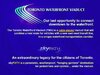
Toronto Waterfront Viaduct, was completed.
Using cantilever cable-stayed construction methods, a new transportation corridor would be built, elevated just above the rail corridor, without almost no interruption to rail traffic.
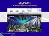
I added a “spectacular” (somebody else’s quote ;-) public amenity called
skyPATH - a sort of hanging gardens of Babylon below the deck of the viaduct, that would be an all season pedestrian and cycling destination (and a major tourist attraction)… with lots of north/south connections, effectively eliminating the rail corridor barrier for pedestrians/cyclists (via smog-free, temperature-controlled access points). Easy access to the existing PATH network of course. Imagine living in Liberty Village or CityPlace and walking to work in the financial district via skyPATH in a January blizzard.... with your coat slung over your shoulder. The private partner in a public/private partnership would be able to
develop all the reclaimed lands once the Gardiner was dismantled. Lakeshore Blvd. would be transformed into a grand boulevard.
Speed limits on the viaduct through the city core would be a modest 60/70 km/hour but the increased capacity of car/transit/cycle/pedestrian TWV offered would actually
reduce commute times. Future electrification of rail traffic through downtown would be easier as the TWV deck would host it.
So in a nutshell, perhaps the largest city-building exercise in civic history. Bye bye rail corridor and berm barriers, bye bye Gardiner. Much of it paid for by the private sector.
Of course nutin’ happened but I did learn a bit about using Photoshop (did the website, all imaging, media and dreamed up skyPATH etc.). My homemade scribbles don't compare to the render magic of WZMH's proposed new sock over the Gardiner (which leaves the Gardiner standing, albeit dressed up, and adds some 1000m Blade Runner scrapers). But some solid ideas were hopefully communicated.
Two loco (local) guys seeking attention: our (not so) crazy scheme garnered a bunch of media coverage and a presentation at Queens Park. The TV interviews were fun but my 2 favourite moments were these:
1. Jack Layton offered a few thoughts via email… he basically said that the quagmire of issues surrounding “air rights” over the rail corridor will kill this in an hour or so. Good luck guys.
2. Our concept was featured in a “
Future of The Gardiner” public meeting at the Metro Convention Centre… and the
organizers didn’t even contact us (they stole the images I guess lol)! At least admission was free.
Below is a PDF snapshot of our full case if you're in the mood to scroll or your Netflix subscription has lapsed. I've posted lots of the (smaller) slides below for a slightly briefer look at the idea.
Toronto Waterfront Viaduct - full presentation (PDF) - (includes BUDGET Estimates/Financing Strategy etc.)
PDF
Note: Open the PDF above with Adobe Reader - it takes a minute to load and sometimes lands mid-presentation - just scroll to the top to start the full tour.
SAMPLE SLIDES - PART 1
END OF PART 1


 A bad but towering joke I concocted 15 years ago. The empty arena seats did sorta foreshadow the Raptors’ (pandemic) 2020 title defence.

 A very small version of my (oh so cleverly titled) “Model City” assembly… I mostly ripped off forgiving UT photogs’ shots of sales centre models (am sure I got permission). NOTE: the old 1 Bloor East model.
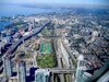
 Another tiny pic of a very large future render circa 2012-ish. Finally made a few buck$ for my doodles - a corporate commission. Koops helped out a lot (I paid him $1.79 per hour). Best of all I got to boss around an aerial photographer (airplane not drone back then) for the base photo.
 Thanks for wasting time with me (use the blue thumbs up... I may have mentioned my crappy reaction score).


") I almost forgot about that one... the good old days!
I almost forgot about that one... the good old days!

 :
: