News   GLOBAL  |  Apr 02, 2020
 8.9K     0 
News   GLOBAL  |  Apr 01, 2020
 40K     0 
News   GLOBAL  |  Apr 01, 2020
 5.1K     0 

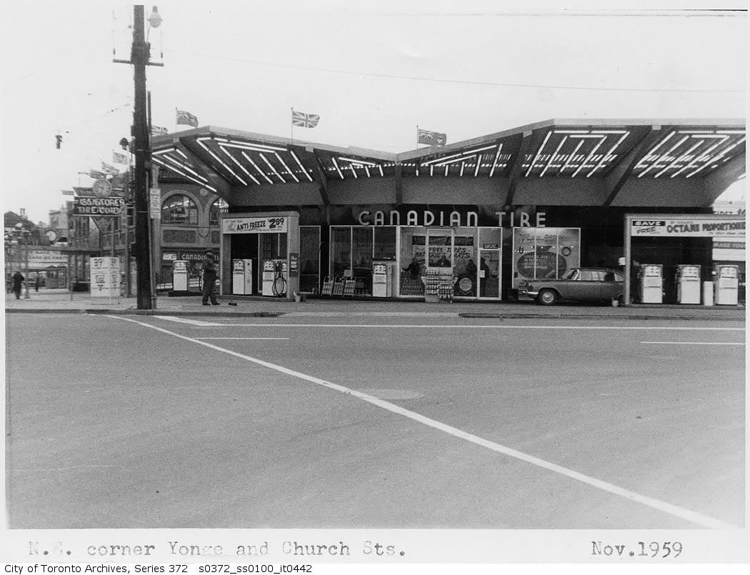
"Nice shot of Lawrence and Roanoke there. Where'd you get that picture from?".


it is from a large hardbound book published in 1967 provocatively called "Toronto"; with photographs by Boris Spremo, who was a staff photographer at the Toronto Star for decades. i believe it was the first mainstream "coffee table" book dedicated to documenting the growing city. its actually quite a beautiful book....

amazon has a few copies kicking around:

http://www.amazon.com/gp/offer-listing/B002NCWZDI/ref=dp_olp_0?ie=UTF8&condition=all
 
Last edited:
City Adult Learning Centre, 1 Danforth Avenue, 1962
Architect: unable to locate


DSC00446_zps4e65216f.gif

DSC00448_zpsc0f1c2c9.gif

DSC00485_zpsd48561d1.gif

DSC00452_zpsd38a39df.gif

DSC00439_zps92067e06.gif

DSC00431_zps69268df8.gif

DSC00455_zps6f2667b9.gif

DSC00477_zps1eb442a7.gif

DSC00472_zpseee4d3ec.gif

DSC00405_zps2bf940cc.gif

DSC00415_zps3cb19a3e.gif

DSC00445_zps546cf55b.gif

DSC00493_zps0cde4558.gif
 
These 1960s school buildings exemplify creativity in a refined and confident form. The use of colours, curves, crisp lines, patterns, angles, and materials makes for lively and engaging facades. It looks to have been a golden era for school architecture in Toronto with buildings like Lord Lansdowne PS, the Central Tech arts school, Carleton Village PS, and Davisville Public School (which is now threatened with demolition). These buildings must be preserved, but leave it to a perpetually cash-strapped school board to threaten each one in time.
 
Last edited:
Sorry, deepend, 1950's (or 40's?), but until demolished in the mid-80's the coolest gas station in town:

s0372_ss0100_it0442.jpg


s0372_ss0100_it0443.jpg


s0372_ss0100_it0441.jpg
 
it is from a large hardbound book published in 1967 provocatively called "Toronto"; with photographs by Boris Spremo... amazon has a few copies kicking around

One less now. Thanks kindly for hipping us to that, Deep. :)
 
Nice shot of Lawrence and Roanoke there. Where'd you get that picture from?

The most fascinating thing for me is the realization that three or four years before the photo was taken, Roanoke was Lawrence Avenue. I've always wondered how the folks in Don Mills, less than a mile away, managed having a one-lane bridge over the Don, and a rickety wooden bridge over the railway line, for pretty much a decade before the new spans we all know today went in. They seem to have taken it entirely in stride because I've never seen a peep written about it.
 
The most fascinating thing for me is the realization that three or four years before the photo was taken, Roanoke was Lawrence Avenue. I've always wondered how the folks in Don Mills, less than a mile away, managed having a one-lane bridge over the Don, and a rickety wooden bridge over the railway line, for pretty much a decade before the new spans we all know today went in. They seem to have taken it entirely in stride because I've never seen a peep written about it.


Probably less than a decade; Lawrence was "straightened" c1960, and Don Mills started to develop c1953/54. And if they "managed", it's probably because little yet compelled them to travel in that direction--as opposed to downtown Toronto...
 
Probably less than a decade; Lawrence was "straightened" c1960, and Don Mills started to develop c1953/54. And if they "managed", it's probably because little yet compelled them to travel in that direction--as opposed to downtown Toronto...

I suppose. If you were working on the Golden Mile, say, by that time you could simply drive down Don Mills Road and turn onto Eglinton, which was open between Victoria Park Ave and Brentcliffe Road by then. But it was still quite a while. If I remember correctly from the aerial shots I copied from the city archives, the construction of the current course of Lawrence, with its major set of bridges, was contemporaneous with the construction of the DVP north from Eglinton. I seem to recall it being under construction in the 1963 shot. Just seems like a long time to have such a bottleneck walking distance from a community of thousands of people. Generally the infrastructure precedes development but I acknowledge Don Mills was at the forefront of this kind of thing.
 
Actually, I think the "straightened" Lawrence might plausibly have been finished before (and in preparation for) the DVP opening this far--or else if you did see construction in a 1963 shot, it may have involved the DVP *north* of Lawrence. (I believe the first "opened" stretch of the DVP was from the Bloor Viaduct to Lawrence, rather than Eglinton--or if it was to Eglinton initially, it went to Lawrence not all that long after. But it definitely did terminate at Lawrence at some point.)
 

Back
Top