Screenshot-2023-11-18-at-10.34.33%E2%80%AFPM.png


Screenshot-2023-11-18-at-10.35.53%E2%80%AFPM.png
 
Not sure how realistic this is, but I'm sold on the vision:
“We really want this development to be a catalyst for the re-imagining of the Beltline Trail to be something sort of more for the neighbourhood and the city. We’re looking at ways we can improve the Beltline Trail, we’re looking at ways that we can plan different uses along the Beltline Trail. We’re looking at ways to connect the Beltline Trail to the Humber River, multi-use path and the West Toronto Railpath to create more connectivity,” added Hull.
 
"Teenagers gather around the Chimney to watch the local puppet show"

Yup, sounds like standard teenage behaviour
Unless the teenagers in question genuinely prefer children's stuff:


After all, there are many adult fans of My Little Pony, Lego, Mario, Pokémon, and Kirby.
 
Unless the teenagers in question genuinely prefer children's stuff:


After all, there are many adult fans of My Little Pony, Lego, Mario, Pokémon, and Kirby.
Manchilds
 
Not sure how realistic this is, but I'm sold on the vision:

Yeah, I saw that.

So I had a look. The short answer is 'not very'.

This site has the Barrie GO Corridor at its western extent, which is a major barrier to going on to the Rail Path Corridor (along the Kitchener GO Corridor), which, in any event, doesn't go that far north yet), or to the Humber River, which is actually 2 Valleys over, The Black Creek Valley is the one immediately to the west, with Black Creek Drive in the way.

IF what he meant was connecting to the Rail Path via the Barrie Corridor, I don't believe that will be feasible with full twin tracks in place.

* Edit * Just checked, the corridor width drops to ~14M a bit south of Eglinton, a 2-track cross section needs about 11M, 3 leftover, including a sound wall, and/or fence is exceedingly tight. So I would say no.
Although..........most of the corridor has a cross-section of ~20M or greater, the choke points are relatively brief. But they would still require property acquisition. There is also the matter of bridging the major roads, of course.

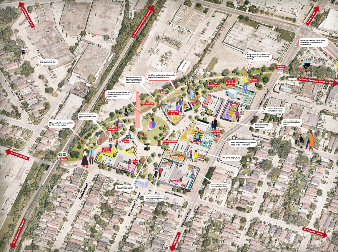
Below is the straight-line distance from the site (Beltline Trail) to Black Creek Trail:

1700587040075.png


That's about 1.25km

Currently the only track crossings are at Eglinton and then Castlefield to the north.

This is the distance to the Humber Trail: (straight line)

1700587210844.png


That's ~3.7km.

That's across 2 rail corridors and the Black Creek Valley.

****

I do appreciate ambition; but unless they've come up with something truly creative, I would file this under hyperbole.
 
I would be thinking more southward, actually. There's cycling infrastructure on Eglinton West, but it ends suddenly. If Eglinton between Caledonia and Black Creek gets safe, segregated cycling infrastructure then you can basically cycle safely between Yonge and Dixie using the Beltline and separated cycling paths on Eglinton.

There needs to be a decent connection between Eglinton and the Humber because what is there is sub-par, to put it mildly, but that would really expand North York's access to the network of recreational paths.
 
FYI all, there is *NO* plan to continue the trail up this far. As @Northern Light notes, the Newmarket Sub / Barrie Corridor isn't wide enough for two tracks and a path, and Metrolinx isn't going to put a path underneath (or anywhere near, likely) live catenary (whenever they get around to that). Forget what Jeff says in the article, it's not happening. @crs1026 / @ShonTron
 
I stumbled across this thread by accident but I gotta say I love the look of this project. Not only is there colour (the importance of which cannot be understated)

There seems to be an emphasis on making an actual livable community here rather than simply plopping a couple towers down in a suburban strip mall. We need more like this!
 
Last edited:
FYI all, there is *NO* plan to continue the trail up this far. As @Northern Light notes, the Newmarket Sub / Barrie Corridor isn't wide enough for two tracks and a path, and Metrolinx isn't going to put a path underneath (or anywhere near, likely) live catenary (whenever they get around to that). Forget what Jeff says in the article, it's not happening. @crs1026 / @ShonTron

I know of no plan to do what is suggested, and I don't see one appearing anytime soon. It's great when one can leverage a rail right of way for a trail, but sometimes that just isn't in the cards... railway rights of way just aren't that accommodating. One has to keep in mind that the Railpath leverages a whole separate abandoned rail right of way that ran beside the current Metrolinx line..... that project never really squeezed a trail out of a rail line that remained active, it simply repurposed an unneeded rail line..

I can't help but note just how many side streets there are that connect the desired points.... if we can't restructure local roads to make safe cycling and pedestrian pathways,...Osler to Cloverdale to Chambers for instance gets you a long way north if the roads and intersections were modified a bit.

I have mused about a "keystone house" strategy to link back streets to create new non-auto pathways in the city - by which I mean, in many places one only has to expropriate and knock down a single dwelling to connect streets and alleyways in the city that were never laid out in a grid. There may be interesting ways to do that and replace the housing capacity and recoup the expense... cantilever houses over paths ? Just a personal fantasy, but that part of the city might find that possible and affordable, and keeps cycling and walkways away from busy main streets.

- Paul
 
Going back to the original quote:

“We really want this development to be a catalyst for the re-imagining of the Beltline Trail to be something sort of more for the neighbourhood and the city. We’re looking at ways we can improve the Beltline Trail, we’re looking at ways that we can plan different uses along the Beltline Trail. We’re looking at ways to connect the Beltline Trail to the Humber River, multi-use path and the West Toronto Railpath to create more connectivity,” added Hull.

There's a few distinct elements.

Connecting the Beltline trail to the Humber River multiuse path

This segment is just over four km. The clearest route that uses existing cycling infrastructure is on Eglinton West. About half of it current does not have cycling infrastructure (in blue), but it's in the cycling plan implementation program. It sounds like the direct connection to the Humber is the stickiest point. Adding the section between Keele and Caledonia in particular would really improve access to stores and restaurants. Unfortunately, there is a bit of a hill.

1700676163573.png


Connecting to the West Toronto Railpath

It's just over 3 km to the railpath. There is currently no cycling infrastructure, but the whole route I've marked below--all of it!--is currently in the near-term implementation program.

1700677057951.png


So frankly I'm unsure what's unrealistic about the idea. It seems very achievable and the City already has plans to do it. If this is the kick in the butt they need so much the better.
 

Back
Top