


junctionist
Senior Member
Without proper signal priority, they'll probably eventually remove it from the map altogether. The map used to show the "Harbourfront LRT", but it was subsequently removed.
|
|
|
Good on you for taking the issue to Metrolinx, nice work.I decided to take the signal priority issue directly to the crosstown team and here's what they had to say.
"Thank you for your interest in the Eglinton Crosstown project. With regards to signal priority, please note that limited priority (request for extended green, or early green if a train is behind schedule) along the Eglinton Crosstown was the finalised agreement with the City of Toronto in the development of the project specific output specifications (PSOS). Unfortunately, at this stage, no further changes will be made."
No chance of real signal priority ever. So except for the track gauge, and the coupled trains, what's stopping us from calling the surface section a streetcar line?
I doubt it as it's being branded differently, just because a few people, a message form don't consider it rapid doesn't mean that it shouldn't be on a map. I tried to make the argument that the airport rocket shouldn't be on the subway map but it's been on to longer than the 604 harborfront was, part of it leaving was probably due to the line being extended to Spadina and becoming 512 Spadina and then later the 509 harbourfront extension to ExhibitionWithout proper signal priority, they'll probably eventually remove it from the map altogether. The map used to show the "Harbourfront LRT", but it was subsequently removed.
It's essentially the new design language being pushed by Metrolinx for Eglinton, Finch, and Hurontario. The boring white and black finishes, the font, the symbols, the diagrams and bilinguality. Personally, it's nice and minimalist, albeit a bit boring.
This should be the actual rapid transit map. Emphasis on rapid, because you know...
View attachment 244303
I think the map should still show the full Crosstown, but show it differently for the above ground portions.
Like change it to an outlined line to indicate its different, and remove the station stops but show it still continuing to Kennedy.
I mean the map shows a bus to the airport FFS.
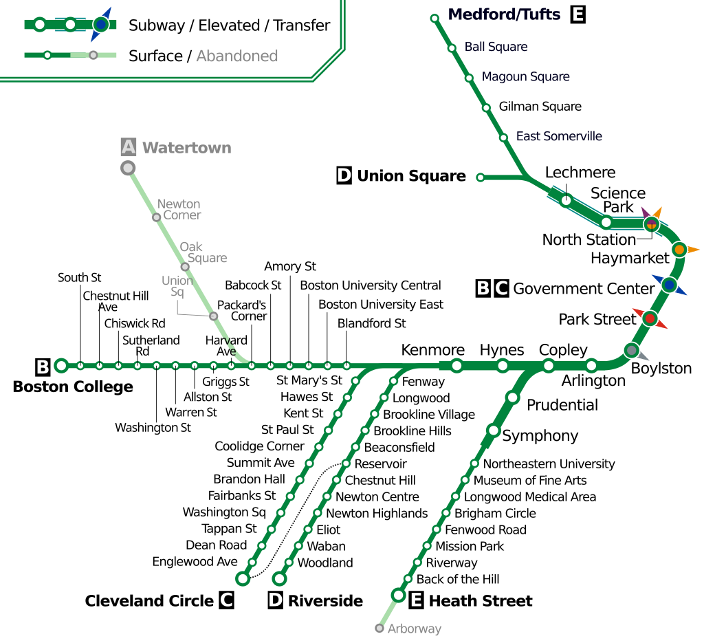
This would just add unnecessary confusion to the public. The system map is designed for navigability not technical correctness. Although the LRT lines would be slower, they are designed to integrate with Subway/RT system with underground connections at Kennedy (Line 5) and Finch West station (Line 6). They are designed to move more riders than the local streetcar/bus with more frequent services.Boston's Green Line shows different thicknesses for surface or subway, but is still classified as "rapid transit".
From link.
The media might do that after it opens. A similar line opened in Minneapolis a decade or so ago and there were complaints and media stories about the red lights and general slowness. That being said, Minneapolis has another line that has proper full priority like Edmonton so they actually know what proper LRT can be.Unless the media picks this up and starts calling this an expensive white elephant project, I doubt city hall would ever take this seriously.
And the actual train that goes directly to the airport is nowhere to be found.I think the map should still show the full Crosstown, but show it differently for the above ground portions.
Like change it to an outlined line to indicate its different, and remove the station stops but show it still continuing to Kennedy.
I mean the map shows a bus to the airport FFS.
You mean like this?I think the map should still show the full Crosstown, but show it differently for the above ground portions.
Like change it to an outlined line to indicate its different, and remove the station stops but show it still continuing to Kennedy.
I mean the map shows a bus to the airport FFS.
Till we find out a BRT would cost over $1 billion. Through it is disappointing, there is hope one day the city will prioritize transit while the LRT brings in more development on the Eglinton than a BRT would.Instead of spending $5.5 billion on the Eglinton Crosstown, we could have spent $55 million on a BRT in Scarborough if we weren't gonna bother with signal priority.
Signal priority is something that could be (relatively) easily added down the road, perhaps we can stop bickering?
^ Though it's worth mentioning that studies have found that BRT has induced as much development along corridors as LRT have.Till we find out a BRT would cost over $1 billion. Through it is disappointing, there is hope one day the city will prioritize transit while the LRT brings in more development on the Eglinton than a BRT would.