News   GLOBAL  |  Apr 02, 2020
 9.6K     0 
News   GLOBAL  |  Apr 01, 2020
 41K     0 
News   GLOBAL  |  Apr 01, 2020
 5.4K     0 

In 20 years we’re going to shut down the eastern half of the line for 5 years to properly grade separate the line and spend another 10 billion dollars to do so.

Let’s spend all this money to build a subway under the central East west avenue across the city, except we’re going to gimp it by using medium not high capacity vehicles and not grade separating it.
call me ignorant, but how does the map indicate its a streetcar?
 
In 20 years we’re going to shut down the eastern half of the line for 5 years to properly grade separate the line and spend another 10 billion dollars to do so.

Let’s spend all this money to build a subway under the central East west avenue across the city, except we’re going to gimp it by using medium not high capacity vehicles and not grade separating it.
In 20 years, Toronto will convert its downtown streets into "transit malls". Not just streetcar transit malls, but bus transit malls. Expect deliveries during certain times.

Angers-Light-Rail-Shared-Space.jpg
From link.
 
call me ignorant, but how does the map indicate its a streetcar?
FMNa79TX0AM4puj

1645558913334.png


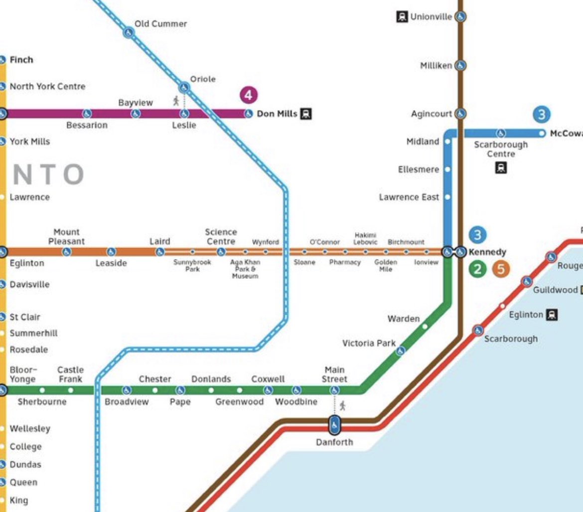
Notice the white line traveling in the middle of the Orange line from Laird to Kennedy: This indicates that this is a streetcar style service - specifically done so that people don't look at this map, and expect subway quality service from the line.

Also notice how the station dots are much smaller, and so is the font used for their names, showcasing how these are "minor stations".
 
How about neighbourhood or community area maps? One that shows the streets & blocks, stores, schools, medical, parks, community centres, and other destinations up to the next station or stop?

If a business wants their store name to be shown on the map, they can pay the TTC for the privilege. A small store (IE. like a "Kims Convince") may pay $100 a year, while a Walmart big store may pay $1,000,000 per year. (Examples only. Don't know what the real price would be.) Schools, parks, and community centres, would be free.
 
Last edited:
FMNa79TX0AM4puj

View attachment 381490

Notice the white line traveling in the middle of the Orange line from Laird to Kennedy: This indicates that this is a streetcar style service - specifically done so that people don't look at this map, and expect subway quality service from the line.

Also notice how the station dots are much smaller, and so is the font used for their names, showcasing how these are "minor stations".
What is "streetcar style"? Less than 10 minute service (even though some US subway or metro have theirs at 10 minutes)? No it is not. Maybe not full transit priority at traffic signals, because the decision makers said so, even though it is possible?
 
What is "streetcar style"? Less than 10 minute service (even though some US subway or metro have theirs at 10 minutes)? No it is not. Maybe not full transit priority at traffic signals, because the decision makers said so, even though it is possible?
Streetcar style as in the operate on street and interact with traffic (its not mixed traffic operations, but it still crosses streets and obeys traffic lights). If the intersections were completely gated where the trains had absolute priority (beyond TSP), maybe you can argue that its something more than streetcar style, but as it stands its basically no different from a european tram.
That doesn't mean it's a streetcar style service like the 501, 504, etc. I don't see those lines on the map.
Its a similar service to the 510/509, and honestly, if Line 5 and Line 6 appear on the map, those 2 lines should as well. Differentiating the 2 makes no sense whatsoever.
 
What is "streetcar style"? Less than 10 minute service (even though some US subway or metro have theirs at 10 minutes)? No it is not. Maybe not full transit priority at traffic signals, because the decision makers said so, even though it is possible?
Is this a case of UT putting words in MLs mouth? Is that a universal style for streetcar routes or is it symbolic of surface grade transit?
 
Is this a case of UT putting words in MLs mouth? Is that a universal style for streetcar routes or is it symbolic of surface grade transit?
Looks like a symbolic surface grade transit stops representation. Not "streetcar" style. The "stations" are shown as bigger circles, while the surface "stops" are shown a smaller circles.
 

Back
Top