News   GLOBAL  |  Apr 02, 2020
 8.9K     0 
News   GLOBAL  |  Apr 01, 2020
 40K     0 
News   GLOBAL  |  Apr 01, 2020
 5.1K     0 

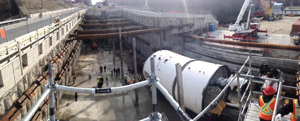
Just took a Streetview trip.

The only ones I see are:
-Credit Union Drive
-Pudham Gate
-Simott Road
-Rosemont Drive

This list only includes streets that cross the track, with stoplights and that don't have any stations at them.

It was far fewer than expected, which is great news. I'm hoping Metrolinx eliminates the intersections from Eglinton. Judging by the amount of cars, they are fairly low traffic.

It also means that signal priority should be significantly easier to manage since they'll only be at stations (if Metrolinx removes the 4 previously mentioned stops), synchronizing arrival at stations shoudn't be too much of a challenge.

Is it yet known if the LRT will be using Stop Request, or will they be stopping at every station? Some on UT seem to think that the surface portion will use Stop Request while Metrolinx has given me the impression that the LRT will be stopping at all underground stations. However I doubt that they'll have implement two different systems on the underground and surface sections. Any thoughts?

The benefit of stopping at every station is that synchronizing signal priority so that two LRVs can pass (EB and WB) will be far easier.

There are 15 in total. It is nice that there is no chance of an LRT being delayed by traffic lights if there is a stop there.

.(see link).

To stop bunching, I think it has to stop at every stop.
 
Last edited:
Those low level stops could be quite simple to prioritize, the outflow from te side streets would be Low enough to signal properly. (They probably only need a 30 second signal every 3 minutes, which can easily be for in between trains)
 
I agree that the way the MBTA does it would work, with the thinner lines for the at-grade portions. I'd still label all the stops though assuming they fit on the map. If they don't though, then yeah. Has anyone tried doing a TTC style map with the Eglinton on it? I know the stops aren't finalized yet but we have a pretty good idea at this point.

BTW when will the line colour be finalized?
 
Those low level stops could be quite simple to prioritize, the outflow from te side streets would be Low enough to signal properly. (They probably only need a 30 second signal every 3 minutes, which can easily be for in between trains)

Knowing this has alleviated any fears of the ECLRT frequently being stopped by traffic. The LRTs travel should rarely be interruped by traffic if singal priority is properly implemented. Metrolinx better make sure the signalling is done correctly.

Is it yet known if there will be some kind of physical barrier between the tracks and vehicles? A guardrail would be nice to prevent pedestrians from crossing the track and interrupting the trains. It would also be nice if the tracks remained unpaved, like they are on the Queensway. That would stop any vehicles from riding on the ROW.
 
I agree that the way the MBTA does it would work, with the thinner lines for the at-grade portions. I'd still label all the stops though assuming they fit on the map. If they don't though, then yeah. Has anyone tried doing a TTC style map with the Eglinton on it? I know the stops aren't finalized yet but we have a pretty good idea at this point.

BTW when will the line colour be finalized?

Probably weeks before the line opens. I doubt anybody at the TTC is stressing over the map design. A 12 year old with Adobe Illustrator can design them in 6 hours for free.
 
Knowing this has alleviated any fears of the ECLRT frequently being stopped by traffic. The LRTs travel should rarely be interruped by traffic if singal priority is properly implemented. Metrolinx better make sure the signalling is done correctly.

Is it yet known if there will be some kind of physical barrier between the tracks and vehicles? A guardrail would be nice to prevent pedestrians from crossing the track and interrupting the trains. It would also be nice if the tracks remained unpaved, like they are on the Queensway. That would stop any vehicles from riding on the ROW.

I would guess they would be paved and with a low curb so they could be accessed by emergency vehicles.
 
LA's Expo Line is fairly similar to our ECLRT in its operation. One of the things I'm concerned about is whether or not the trains will be stopped in situations like this:

http://youtu.be/H73eyHOBH40?t=13m20s

Of course, proper signal priority could completely prevent situations like this while increasing LRV speed. I figure this setup will make situations in the video above rare, if not impossible, while maintaing traffic flow.

-Begin to turning east/west signals to green at least 10 seconds before LRV arrives at the intersection
-No left turns if an LRV is approaching. Allow left turns after LRV has passed.
-Keep north/south signals at red if an LRV is less than 25 seconds away. That gives at least 15 seconds for north/southbound cars to cross and clear the intersection
-Immediately turn north/south traffic lights to green if they were held by the LRT.

I just hope Metrolinx is willing to do this. I would hate to see a repeat of the Spadina priority signalling fiasco.
 
I'm taking the risk that posts about construction of this line, rather than endless navel gazing, are off-topic.

But here's a picture from this morning of the TBM at the launch site.

 
Last edited:
Does anyone know if the line will be run with a central underground route and the longer full crosstown route. It was mentioned way back but I don't recall if a decision was made.
 
This quote has been bugging me for a while:

From the Toronto Star:

How they work: The machines work in pairs so the light rail vehicles can move up and down the line in both directions. There’s really only enough room at the launch site for one machine at a time, so the first TBM is launched a couple of months ahead of its twin.

Is that true?

From Nfitz's photo, there seems to be space for two TBM's side -by -side.
 
This quote has been bugging me for a while:

From Nfitz's photo, there seems to be space for two TBM's side -by -side.

My guess is it has to do with having room to work as well as site access. There doesn't appear to be access on the left side of the picture meaning both machines must be lowered in from the same side of the site. Assembling them one after the other also means the crews will know how to solve any assembly issues, as well as reducing the staffing requirements.

The Star might have been given bad info (there does appear to be enough room to assemble both if it's planned well enough) but space is likely the first in a list of reasons they are staggered.
 
What are you trying to say? You're sentences don't make any sense.
How does it not make sense? I'll rephrase it, and perhaps then you can clarify the grammatical error in my original post. The only error that jumps out at me, is I probably should have hyphenated "navel gazing".

"Here is a photo of the launch site today. Is this the correct place for discussion of the construction, because everyone here seems to be discussing irrelevant BS".

It made sense to me the first time, but I like the wording of the second attempt better.
 

Back
Top