This thread will be used for discussion of Kipling-Eglinton Station: a proposed below-grade TTC station on the Eglinton Crosstown (Line 5) West Extension, serving the intersection of Kipling Avenue and Eglinton Avenue West in Toronto's Richview Park neighbourhood.

You are using an out of date browser. It may not display this or other websites correctly.
You should upgrade or use an alternative browser.
You should upgrade or use an alternative browser.
- Thread starter Paclo
- Start date
W. K. Lis
Superstar
SaugeenJunction
Senior Member
I’m a fan of “Princess Gardens” which captures a few communities to the south. The Kingsway is a long road.Just a suggestion. How about "Kingsway Station" for Kipling & Eglinton? The Kingsway ends at Kipling Avenue, south of Eglinton Avenue West.
From link.
W. K. Lis
Superstar
St. George Station is already taken.I’m a fan of “Princess Gardens” which captures a few communities to the south. The Kingsway is a long road.
View attachment 470920
However, there are two Mt. Pleasant Stations.
From link.
Last edited:
toaster29
Active Member
Most people know The Kingsway to be the neighbourhood along and North of Bloor and East of Royal York. Not here.
fanoftoronto
Active Member
Adding the station entrance locations as shown in the presentation from Metrolinx:

I've mentioned this in the past, but they really should have had the ECWE stations straddle the intersecting roads, and have a second entrance on the opposite side of intersecting roads. This negates the requirement for the north-south bus offloading passengers to cross the busy streets to get to the station entrance.
And I also prefer "Princess Gardens station".
T3G
Senior Member
I find both Kingsway and Princess Gardens to be inappropriate names for the station.
Princess Gardens sounds really nice, I'll not dispute that, but it is not a location that is known to most people - I am a lifelong road geek, map enthusiast, and I know the city well, and have never heard the locale referred to as such before. It appears neither in any street atlas of Toronto I have ever seen, nor is it shown on the city of Toronto's neighbourhood map - the area is filed under "Princess-Rosethorn", itself a fairly arcane designation.
The Kingsway is almost half a kilometre from the proposed station site and is about as helpful to wayfinding as calling St. Clair West station Vaughan.
Nay, the only logical name for the station is Kipling North.
W. K. Lis
Superstar
It's a 15-minute walk from the Pioneer Village Station on Line 1 to the Black Creek Pioneer Village. So, why not Kingsway Station, if distance is not a problem for Pioneer Village Station.I find both Kingsway and Princess Gardens to be inappropriate names for the station.
Princess Gardens sounds really nice, I'll not dispute that, but it is not a location that is known to most people - I am a lifelong road geek, map enthusiast, and I know the city well, and have never heard the locale referred to as such before. It appears neither in any street atlas of Toronto I have ever seen, nor is it shown on the city of Toronto's neighbourhood map - the area is filed under "Princess-Rosethorn", itself a fairly arcane designation.
The Kingsway is almost half a kilometre from the proposed station site and is about as helpful to wayfinding as calling St. Clair West station Vaughan.
Nay, the only logical name for the station is Kipling North.
T3G
Senior Member
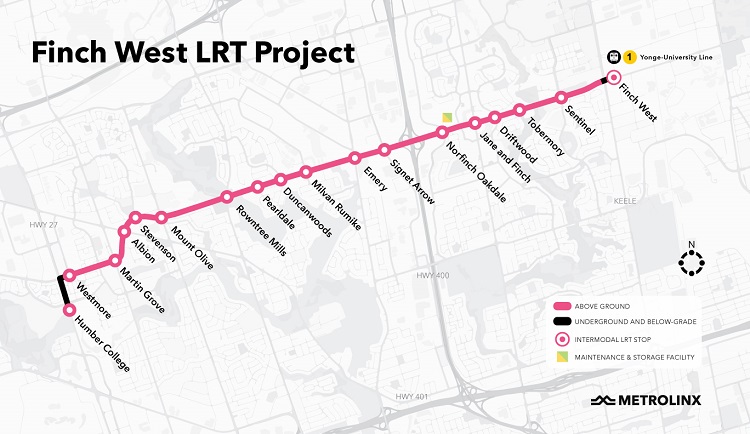
I don't think Pioneer Village was the correct name to choose for the station, Steeles West would've made more sense.
But just because a mistake was made before, doesn't mean we should make it again. Calling this station Kingsway would have zero wayfinding value, which is the sole purpose of a station or stop name.
But just because a mistake was made before, doesn't mean we should make it again. Calling this station Kingsway would have zero wayfinding value, which is the sole purpose of a station or stop name.
Parkdalian
Senior Member
Well, the main purpose is to have a unique identifier - which is why, for emergency purposes, Metrolinx is so fussed about not duplicating names. The secondary purpose is to hopefully provide an indication of where the station is located. This sometimes results in stations with names that are *not* helpful from a wayfinding perspective. I have been living in Toronto for decades, and it always takes me some time and a map to figure out where St Patrick and St Andrew are. But it's also totally fine, and not a significant barrier.I don't think Pioneer Village was the correct name to choose for the station, Steeles West would've made more sense.
But just because a mistake was made before, doesn't mean we should make it again. Calling this station Kingsway would have zero wayfinding value, which is the sole purpose of a station or stop name.
TossYourJacket
Senior Member
And what happens if there's another station North of this one on Kipling? Cardinal directions + street names only works with very few transit lines (a maximum of 3 crossing any given street). While we have used this system in the past, in makes no sense anymore as we aggressively expand the transit system.I find both Kingsway and Princess Gardens to be inappropriate names for the station.
Princess Gardens sounds really nice, I'll not dispute that, but it is not a location that is known to most people - I am a lifelong road geek, map enthusiast, and I know the city well, and have never heard the locale referred to as such before. It appears neither in any street atlas of Toronto I have ever seen, nor is it shown on the city of Toronto's neighbourhood map - the area is filed under "Princess-Rosethorn", itself a fairly arcane designation.
The Kingsway is almost half a kilometre from the proposed station site and is about as helpful to wayfinding as calling St. Clair West station Vaughan.
Nay, the only logical name for the station is Kipling North.
Translude15
Frank the Tank
Nobody refers to this area as Princess Gardens. The entire stretch from Martin Grove to Royal York is collectively called Richview but for transit station purposes, that moniker will likely go to the Eglinton-Islington stop, as the high school is right at that intersection. Martin Grove Station will likely go to the stop at Martin Grove so that's also a non-starter.
Some variation of Widdicombe or Widdicombe Hill would be pretty suitable IMO as the street is just north of Eglinton and Widdicombe Hill Park is just NE of where the station will be situated.
Some variation of Widdicombe or Widdicombe Hill would be pretty suitable IMO as the street is just north of Eglinton and Widdicombe Hill Park is just NE of where the station will be situated.
W. K. Lis
Superstar
Except that "Martin Grove" is being used (at the moment) for Line 6 Finch West LRT.Nobody refers to this area as Princess Gardens. The entire stretch from Martin Grove to Royal York is collectively called Richview but for transit station purposes, that moniker will likely go to the Eglinton-Islington stop, as the high school is right at that intersection. Martin Grove Station will likely go to the stop at Martin Grove so that's also a non-starter.
Some variation of Widdicombe or Widdicombe Hill would be pretty suitable IMO as the street is just north of Eglinton and Widdicombe Hill Park is just NE of where the station will be situated.
Translude15
Frank the Tank
Scratch that then, Martin Grove-Eglinton should probably be Willowridge then.
Sorry, but Kingsway Station would be a bad name for this one. As has already been stated above, when you name drop "The Kingsway" into conversation, locals understand you're either talking about the shopping strip along Bloor on either side of Royal York Road, or the area north of it… or you don't know what you're talking about.It's a 15-minute walk from the Pioneer Village Station on Line 1 to the Black Creek Pioneer Village. So, why not Kingsway Station, if distance is not a problem for Pioneer Village Station.
42