You are using an out of date browser. It may not display this or other websites correctly.
You should upgrade or use an alternative browser.
You should upgrade or use an alternative browser.
steveintoronto
Superstar
What jumps out from this angle, quite unexpectedly, are the Pinewood buildings, especially in the lower pic, a good part being the compressed depth of field bringing the background closer to the foreground in relative distance. It's the first time I've actually admired that building, unless I'm being impressed by a recent remake of it.Thanks @Jasonzed. This is the type of project that drone footage really excels at capturing.
Aplus23
Active Member
So the part where the sand/dirt is in the lake, will eventually be filled in, and then what?? Are they building on top of that eventually. I think i read it will be a park?? Why exactly are they infilling on this, sorry I am new here
DSC
Superstar
Short answer: a park. Long answer: I suggest you look at the WT site where the project is explained and, if you have the time, look back on this thread. https://www.waterfrontoronto.ca/nbe/portal/waterfront/Home/waterfronthome/projects/lower+don+landsSo the part where the sand/dirt is in the lake, will eventually be filled in, and then what?? Are they building on top of that eventually. I think i read it will be a park?? Why exactly are they infilling on this, sorry I am new here
W. K. Lis
Superstar
tstormers
Senior Member
Read this interesting Article today form 2014 regarding the bedrock along Toronto's waterfront about rock squeeze.
http://spacing.ca/toronto/2014/10/03/torontos-swelling-bedrock/
Not sure how deep they really have to go to be stable as the above says because at "The Well" the bedrock is only 10m below the soil which isn't very deep to be stable. They go further due to what they require for the building. It's possible that the bedrock in the "Ashbridge's Bay Marsh" area that the bedrock isn't that far down to still have stable foundations.
drum118
Superstar
September 27, 2018
CONSTRUCTION NOTICE #6: Port Lands Flood Protection
Partial Lane Closures: Thursday September 27 – Friday October 19
From September 27 to October 19 between the hours of 7:00am-7:00pm on weekdays and 9:00am – 7:00pm on Saturdays crews will be working on the following locations:
These closures will allow crews to drill geotechnical boreholes on Commissioners Street to inform the design of the new Commissioners Street bridge. Find details about what we’re building as part of Port Lands Flood Protection here.
PORT LANDS FLOOD PROTECTION – PROGRESS UPDATE
What to expect this fall
Construction crews are preparing to start demolition at the intersection of Commissioners and Cherry Streets. The demolition work includes removal of the asphalt and concrete parking lot, and buildings on-site. There will also be topsoil scrapped and stockpiled, site grading, installation of drainage and sediment and erosion control measures, environmental and geotechnical drilling on roads and boulevards, and surveying.
This map shows the areas where work has started and will continue through December 2019.

Area 1:
Area 2:
Area 3:


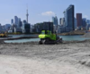
In addition to these activities, crews will be digging pits (left) to collect soil and groundwater samples.
Monitoring for air, noise, dust and vibration continues at test points throughout the Port Lands area (right).
Crews will also be conducting survey work and environmental sampling to establish construction approach.
CHERRY STREET LAKEFILLING – PROGRESS UPDATE

The latest aerial image of the Cherry Street Lakefilling project, showing the new shoreline taking shape, lakefilling progress on the south side of Essroc Quay and dockwall progress to the north.


Lakefilling continues (left). A total of 16,094 truckloads of locally sourced clean fill will be placed around Essroc Quay to form the northwest corner of the future Villers Island. Marine landscapers are in the final stages of shaping the first layer of the core stone, the aggregate that will make up the new shoreline (right). The crew is preparing for the second layer of stone by installing the geotextile cloth. The final step will be to secure the shoreline with armor stone, arriving by truck this month.
QUESTIONS:
To learn more about this project, please visit portlandsto.ca. Use this online form to send us questions or concerns about construction or email us at plfp@ellisdon.com. For urgent construction related issues, please contact Cameron Coleman, EllisDon, at 416-464-3583.
CONSTRUCTION NOTICE #6: Port Lands Flood Protection
Partial Lane Closures: Thursday September 27 – Friday October 19
From September 27 to October 19 between the hours of 7:00am-7:00pm on weekdays and 9:00am – 7:00pm on Saturdays crews will be working on the following locations:
- Commissioners Street (between Don Roadway and Saulter Street)
- Commissioners Street (between Don Roadway and Munitions Street)
These closures will allow crews to drill geotechnical boreholes on Commissioners Street to inform the design of the new Commissioners Street bridge. Find details about what we’re building as part of Port Lands Flood Protection here.
PORT LANDS FLOOD PROTECTION – PROGRESS UPDATE
What to expect this fall
Construction crews are preparing to start demolition at the intersection of Commissioners and Cherry Streets. The demolition work includes removal of the asphalt and concrete parking lot, and buildings on-site. There will also be topsoil scrapped and stockpiled, site grading, installation of drainage and sediment and erosion control measures, environmental and geotechnical drilling on roads and boulevards, and surveying.
This map shows the areas where work has started and will continue through December 2019.
Area 1:
- Demolition
- Stockpiling topsoil removed from elsewhere on-site
Area 2:
- Demolition
Area 3:
- Demolition
- Preparing for river excavation (removal of the topsoil)
In addition to these activities, crews will be digging pits (left) to collect soil and groundwater samples.
Monitoring for air, noise, dust and vibration continues at test points throughout the Port Lands area (right).
Crews will also be conducting survey work and environmental sampling to establish construction approach.
CHERRY STREET LAKEFILLING – PROGRESS UPDATE
The latest aerial image of the Cherry Street Lakefilling project, showing the new shoreline taking shape, lakefilling progress on the south side of Essroc Quay and dockwall progress to the north.
Lakefilling continues (left). A total of 16,094 truckloads of locally sourced clean fill will be placed around Essroc Quay to form the northwest corner of the future Villers Island. Marine landscapers are in the final stages of shaping the first layer of the core stone, the aggregate that will make up the new shoreline (right). The crew is preparing for the second layer of stone by installing the geotextile cloth. The final step will be to secure the shoreline with armor stone, arriving by truck this month.
QUESTIONS:
To learn more about this project, please visit portlandsto.ca. Use this online form to send us questions or concerns about construction or email us at plfp@ellisdon.com. For urgent construction related issues, please contact Cameron Coleman, EllisDon, at 416-464-3583.
Attachments
-
 upload_2018-9-27_17-58-27.png212.3 KB · Views: 621
 -
 upload_2018-9-27_17-58-27.png220 KB · Views: 635
 -
 upload_2018-9-27_17-58-27.png85.4 KB · Views: 615
 -
 upload_2018-9-27_17-58-27.png170.5 KB · Views: 607
 -
 upload_2018-9-27_17-58-27.png123.9 KB · Views: 618
 -
 upload_2018-9-27_17-58-27.png327 KB · Views: 693


AlvinofDiaspar
Moderator
From the Sept WTDRP:
Detailed Design: https://waterfrontoronto.ca/nbe/wcm...For+WT+Website+(1)-compressed.pdf?MOD=AJPERES
Park/Rivers/Roads: https://waterfrontoronto.ca/nbe/wcm....WDRP_3A_WATERMARK-compressed.pdf?MOD=AJPERES
AoD
Detailed Design: https://waterfrontoronto.ca/nbe/wcm...For+WT+Website+(1)-compressed.pdf?MOD=AJPERES
Park/Rivers/Roads: https://waterfrontoronto.ca/nbe/wcm....WDRP_3A_WATERMARK-compressed.pdf?MOD=AJPERES
AoD
jaco_says
New Member
Dedicated turn lanes, on-street parking right next to a cycle lane, and crazy wide lanes and ROWs. This design belongs in suburbia, not a city. It is completely un-urban. These roads are designed to be sped on. The city just doesn't get vision zero.
innsertnamehere
Superstar
looks pretty similar to street designs in the Pan Am Village - and those feel quite safe. Not sure what the issue is?
jaco_says
New Member
The PanAm village is not a throughway. The PanAm village is also incredibly cold and sterile with an incredible distance between buildings. It was poorly conceived and not something to emulate.
smably
Senior Member
3.6m car lanes? Ugh!
With the width of the ROW, pedestrian crossing times are going to be looooong, so every light cycle will have to be long too. Transit signal priority will be tough.
The city really needs to better consider the costs of these enormously wide ROWs.
With the width of the ROW, pedestrian crossing times are going to be looooong, so every light cycle will have to be long too. Transit signal priority will be tough.
The city really needs to better consider the costs of these enormously wide ROWs.
ADRM
Senior Member
Yeah, I quite dislike what they did with the roads in the Canary District -- they're too wide, there's no traffic calming, the cobbles are awful for cyclists, the bike lanes are in the dooring zone, and they're all un-protected.
torontologist
Active Member
The PanAm village is not a throughway. The PanAm village is also incredibly cold and sterile with an incredible distance between buildings. It was poorly conceived and not something to emulate.
3.6m car lanes? Ugh!
With the width of the ROW, pedestrian crossing times are going to be looooong, so every light cycle will have to be long too. Transit signal priority will be tough.
The city really needs to better consider the costs of these enormously wide ROWs.
Unfortunately provincial regulations require the ROWS to be this wide. City Planning wanted them to be narrower in the PanAm/West Donlands, but they couldn't override provincial legislation. As long as Queens Park is in the thrall of suburban and rural mediocrity, we're not going to see anything new with narrow ROWS. Updating these rules is just not on the agenda.
Also our firetrucks are so frickin' huge, which poses a problem.
44 North
Senior Member
From the Sept WTDRP:
Detailed Design: https://waterfrontoronto.ca/nbe/wcm/connect/waterfront/88e9a5b0-020f-4e03-9717-c1c296553830/2018-09-26-PLFPEI-+DRP+Presentation-FINAL-For+WT+Website+(1)-compressed.pdf?MOD=AJPERES
Park/Rivers/Roads: https://waterfrontoronto.ca/nbe/wcm....WDRP_3A_WATERMARK-compressed.pdf?MOD=AJPERES
AoD
Great cross-sections in that second document. Really shows the scale of engineering this is. Years ago thought they'd carve out some dirt then let river run its course. Instead this is like a monumental scale of engineered naturalization. So very much armour stone.
Yeah, I quite dislike what they did with the roads in the Canary District -- they're too wide, there's no traffic calming, the cobbles are awful for cyclists, the bike lanes are in the dooring zone, and they're all un-protected.
It's unfortunate that the days of narrow streets, lanes, and alleys are pretty much passed us, and that it's effectively built in that way. Would be great to see something akin to Tokyo, but instead it's more N.Am suburbanized faux urban. Insertname explained it pretty well to me in the past in that we need long sightlines and wide arcing curves for things like getting honking firetrucks every which way. But it's unfortunate. Is it really actually safer in the end. Lots of peds and vehicle accidents on neighbourhood roads with long sightlines and wide curves, though can't think of any within our older neighbourhoods with tight grids and narrow streets/alleys. If drivers can't see what's around the corner most do the logical thing and drive with caution.