You answered the your own query there, its the Queen to Dundas section that would be at issue.
Leave the plaform south of Queen then, and it's still no worse there than the previous proposal, and better than the current one to the north.

But hang on, the alignment is already extra-wide just north of Queen, because there's still the old island platform there from Riverdale station.

I suppose you'd lose a little tiny piece of greenspace right near Queen and Degrassi where the old station building use to be, when they build the new station building. But the community wasn't happy when that happened in the first place as far as I recall. And it certainly wouldn't impact up to Dundas.
 
Leave the plaform south of Queen then, and it's still no worse there than the previous proposal, and better than the current one to the north.

But hang on, the alignment is already extra-wide just north of Queen, because there's still the old island platform there from Riverdale station.

Without proper drawings, we can't say for sure what the impact would be; and Mx has been less than forthcoming in sharing their homework.
 
The community should give a little, take a little.

Agree to cut-and-cover from East Harbour/Broadview east and north to Don Valley.

In exchange, Metrolinx follows the RL route from downtown, under Don River to East Harbour/Broadview. Here is continues on Eastern (or just south of it) to Pape and up Pape to the Don Valley.

  • Metrolinx saves hundreds of Millions of construction dollars. Zero portal construction required. Less curves than currently planned. A slightly shorter route. They get a fully climate controlled transit line (in this portion) that is not subject to the weather.
  • Locals get a fully underground transit through their neighbourhood, a station a bit farther into Leslieville, and get slightly more disruptive but shorter duration construction using cut-and-cover.

View attachment 308564
You'll have the people that fought against the pape alignment screaming if you have to demolish their homes or have no access to the roadway for months.
 
Without proper drawings, we can't say for sure what the impact would be; and Mx has been less than forthcoming in sharing their homework.
Very true.

Another advantage of putting the Ontario tracks all on one side, is it does make it easier for Metrolinx and/or Via to add a 5th and 6th track in the future.
 
^ Yes that's my understanding.
A rough interpretation of what I think is happening? Red = portals

[I've been corrected will fix]

Just wanted to update my earlier post where I got the location wrong. Very rough, not to scale, quick visual of the shift to both OL tracks on the north/west side of the existing LSE/ST/VIA corridor. It's at a high level so it may appear to show the OL tracks outside of the Metrolinx ROW but that's not the intent. I think I read in a recent post someone mention that they don't see Metrolinx removing existing LSE/ST/VIA heavy rail tracks? It just looks like when you zoom in that there could be space on the south/east side for the shift. Maybe if I have time I'll do a rough sketch in certain parts. The location that has that old centre platform is kind of interesting. Again, but be to scale and I'm not a civil engineer.

1616971197518.png


Map left from here - previous alignment of OL on either side of GO; map centre from here and ditto; map right - OL tracks on north/west side given the recent news using Google Maps.

I wonder if using open streets map from here would also provide a good view of the potential track arrangement (2 OL; 4 GO/VIA), or this map.
 
If you work on the north side of the CBD - like at Eaton Centre - the transfer may be shorter / less harrowing than power walking from Union Station with the other lemmings.
However, an evening commute transfer would mean you probably won't get a seat on the GO train (I wouldn't expect one on the Ontario Line subway), plus taking the subway for a timed transfer at East Harbour can be more risky than walking to Union Station.

I could see Corktown Station becoming an elevated station closer to the Don River bridges instead of underground - that would save some costs.
Except with GO RER there won't be a "timed transfer". The current plans during peak hours for GO RER call for 11 TPH in the peak direction on the Stouffville Line (or a train every 5.5 minutes) and 4tph on LSE with an additional 5 tph that act as express trains and skip all stops to Pickering (I put that separately because the IBC made no mention of East Harbour, so whether or not those trains will stop at East Harbour is up to Metrolinx to decide, but if they do, that bumps LSE to 9TPH or a train every 6 minutes and 40 seconds). In short, under the current plans, unless your final destination is Eglinton, Guildwood, or Rouge Hill, trains will come frequently enough during peak hours that the transfer isn't a problem at all on a time scale.
 
Except with GO RER there won't be a "timed transfer". The current plans during peak hours for GO RER call for 11 TPH in the peak direction on the Stouffville Line (or a train every 5.5 minutes) and 4tph on LSE with an additional 5 tph that act as express trains and skip all stops to Pickering (I put that separately because the IBC made no mention of East Harbour, so whether or not those trains will stop at East Harbour is up to Metrolinx to decide, but if they do, that bumps LSE to 9TPH or a train every 6 minutes and 40 seconds). In short, under the current plans, unless your final destination is Eglinton, Guildwood, or Rouge Hill, trains will come frequently enough during peak hours that the transfer isn't a problem at all on a time scale.
But will all of them stop at East Harbour?
 
But will all of them stop at East Harbour?
From what we know, the 11 for Stouffville and 4 for LSE are an absolute yes. The only part that is uncertain is the 5 peak hour express trains on LSE, but that's up to Metrolinx to decide whether they think they should run those or not.
 
I think some of the people pushing for this proposal and the additional station would fight against increased density.

Sure...but the same is true of almost any area of the city with established neighbourhoods. The city itself admits that the lower density nature of Scarborough is unlikely to change all that much with the SSE.

Everyone wants subways, but not everyone wants to live in the kinds of environments they were designed for.

I really can't blame the residents for being passionate about their community. This is on the government for throwing away a perfectly good plan and completely contradicting themselves with other projects.
 
I have no dog in the fight, but the local NIMBY group is framing the issue very well. They are focusing on the impact on local parks, not the impact of noise or real estate values that come with an elevated line. Also, they seem to be a somewhat more diverse and media savvy group than the typical 70 year old man-yells-at-cloud crank.

Edited for clarity.
 
Last edited:
I have no dog in the fight, but the local NIMBY group is framing the issue very well. They are focusing on the impact on local parks, not the impact of noise or real estate values that come with an elevated line. Also, they seem to be a somewhat more diverse and media savvy group than the typical 70 year old man-yells-at-cloud crank.

Edited for clarity.
More than 70...
e5c.jpg

From link.
 
Subject to design drawings we don't yet have, the probability is that putting all the tracks on the west side, would eliminate all the parks along Degrassi from Queen to Dundas.

I'm not sure why putting the tracks on the north side would impact parks on the north any more than the current plan. Ultimately it should have less impact because you have a narrow cross-section, with only one extra-wide spacing between the transit and GO tracks, rather than two. Presumably it shifts the fourth GO track further south (east).

I think that it would have a wider impact if they built the lines (double track) on a 'bench' that extends the GO corridor embankment.
If they instead build the line elevated on columns, there is less square footage used 'on the ground' and the areas below the line remain accessible.
The areas would be in shadow, but the appearance can be mitigated with plantings, etc. as it is under the SkyTrain lines in Vancouver.
That's the dirty little secret of elevated lines - the space below the guideway remains largely useable.

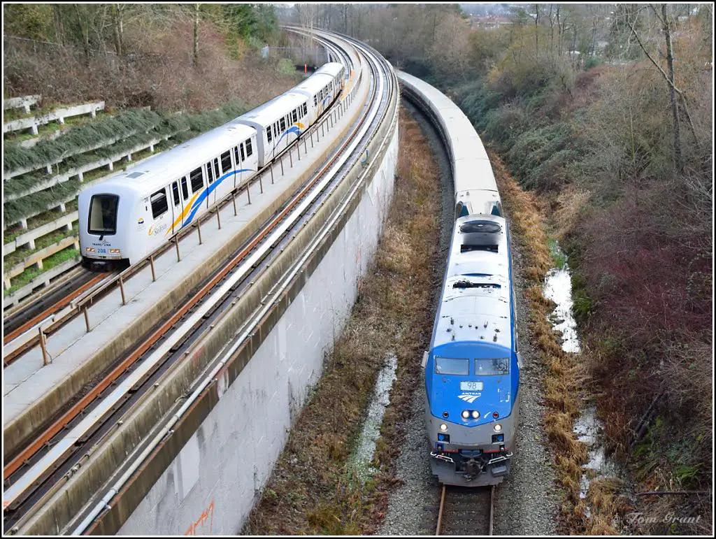
For a width reference, here's SkyTrain on a 'bench' in Grandview Cut:
130547426.jpg


Community gardens under SkyTrain guideway:
ccg.jpg


This building shown in Steve Munro's blog post seems to be probematicly close to the north side RoW:
broadvieweasterncarlaw4west.jpg


This area along Commercial Drive is about the closest that the guideway comes to buildings in Vancouver (other than integrated projects):

wMgi3tb.png


ciCGVGN.png

 
Last edited:
That building next to the north side RoW is a storage facility (I thought it was an apartment building).
That being the case, they can probably build right next to it without complaints (better for the property owner than demolition)
or demolish just a portion of the building.

Here's the proximity from Google Maps.
They can probably squeeze an elevated guideway through there.

H3DIgkz.png

SL8EnTZ.png


Back
Top